
(Heerbrugg, Switzerland, 1 April 2015) – Leica Geosystems announces a group of six major new products for terrestrial laser scanning: three new laser scanners and three new point cloud software products. Together, these leading edge products raise the industry’s bar for laser scanning data quality and productivity, both in the field and the office.
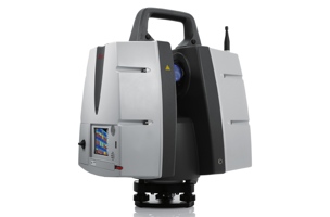
New Leica ScanStation P40, P30, and P16 laser scanners on the leading edge
Leica ScanStations P40, P30, and P16 feature state-of-the-art advances in LIDAR and digital imaging as the 8th generation of Leica Geosystems versatile, high performance laser scanners. These new, ultra-high-speed scanners increase field and office productivity, while simultaneously grabbing users’ attention with strikingly sharper, crisper scans and HDR true color images – even under many conditions traditionally difficult for scanning. Users will be able to capture more useful data from a single set-up, which translates into fewer instrument setups and greater productivity. Three models meet different user needs: the Leica ScanStation P40 and P30 add survey functionality, longer range capabilities (to 270m for P40), and advanced scanner controls for additional versatility and productivity while the Leica ScanStation P16 is a short range, introductory model.
New software expands Leica Geosystems point cloud solutions
In addition to the major new software releases Leica JetStream and TruView Global products, Leica Geosystems announces Leica CloudWorx for Navisworks – a popular design review application from Autodesk – as its newest family member of CloudWorx plug-ins for CAD and VR applications. JetStream is a combined project data vault and high-performance data streaming server that takes Cyclone data and serves it up in a high-performance format that enables a CloudWorx user to be up to 40% more productive when working with point clouds. Much of that gain comes from instantaneous loading and navigation of point clouds – eliminating traditional “waiting times” long associated with point cloud office work. Lastly, TruView Global greatly increases anyone’s access to TruViews – Leica Geosystems’ popular, intuitive application for viewing and measuring scans. Shaking free from prior constraints, TruViews will be accessible within any Internet browser on any mobile device or computer, with no App or plug-in to install.
Combined benefits for users
Taken together, advances in the new scanners and software elevate laser scanning to a new performance and data quality level. The new scanners are all ultra-high speed (up to 1 million points/sec) and can capture more useful data from a scene. In addition, increased user access to TruViews plus good HDR digital images will encourage users to publish TruViews even more frequently. All of these factors drive users to create more dense scans and larger data sets. With the complementary Leica JetStream software, users have the ability to handle these larger data sets with astonishing ease. This combination of the new line of Leica Geosystems scanners plus the new Leica Geosystems point cloud software products raises the practice of laser scanning – or High-Definition Surveying™ (HDS™) – to the next level, setting a new industry standard.

An overall scanning solution
Leica Geosystems offers customers a complete scanning solution. With the latest Leica Cyclone software, the industry’s leading point cloud solution for processing laser scan data, users benefit from fast and easy scan registration and a variety of valuable features, resulting in a quicker creation of highly accurate and detailed results. Along with its hardware and software, Leica Geosystems offers customers worldwide support as well as training and technical service from the laser scanning industry’s largest, most experienced, and knowledgeable team. It is tailor-fit to suit customers’ needs and will keep cost of ownership down and workflows smooth.
Availability
The Leica ScanStation P40, P30 and P16 are immediately available. Leica JetStream, Leica TruVeiw Global and Leica CloudWorx for Navisworks are planned for release Q2 2015. Ordering information and details are available from all authorized Leica Geosystems representatives.
Further information about the Leica ScanStation P16, P30, and P40 and an exciting new video on the Leica ScanStation P40 can be found at: http://www.leica-geosystems.com/scanstation


