NORCROSS, GA, DECEMBER 1, 2014 – Leica Geosystems Inc. today announced that Langan Engineering & Environmental Services based in Elmwood Park, N.J., has expanded its surveying and mapping capabilities by purchasing the Leica Pegasus mobile mapping solution. The multidisciplinary firm is already providing mobile mapping services on several major transportation projects and has had inquiries from other agencies, organizations and existing clients that are interested in exploring the benefits of the Leica Pegasus solution.
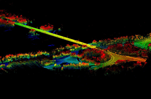
The compact Leica Pegasus is a plug-and-play hardware solution that include cameras and LIDAR sensors as well as a complete software solution with data acquisition, calibration, post-processing, viewing, editing and storage modules. Designed to meet the needs of both inventory-grade and survey-grade mapping projects, the system combines a precise GNSS receiver with a robust IMU to provide a position accuracy of 2 cm RMS. It provides an easy process for object capture and referencing through Map Factory software, an extension of ArcGIS that allows Esri users to use stereoscopic images and LIDAR data for the acquisition, editing and updating of 3D features directly within the Esri environment. The software enables data to be processed and shared quickly, often with a one-to-one ratio of data collection and processing time.
“The value we’re able to provide to our clients with the Leica Pegasus solution is key,” said Joseph Romano, PLS, principal of Surveying & Mapping at Langan. “While mobile mapping has been on the market for a number of years, it has always been limited by the extensive amount of processing required to extract and use the data. Having the ability to extract data into a user-friendly GIS environment without having to model that data or become an expert in how to manipulate that data is a game changer.”
The mobile mapping services are being offered through Langan’s Surveying & Mapping group, which has a long history of applying both traditional survey methods and cutting-edge technologies such as 3D laser scanning to meet clients’ needs and maintain project schedules and budgets. Leading the new discipline is Stephen Ellis, GISP, CMS, who brings 29 years of experience in engineering, mapping, survey, geographic information systems (GIS), and information technology (IT). Ellis has managed a number of high-profile projects involving the development of solutions for the enterprise-wide delivery of spatial information, needs/gap analysis, strategic and implementation planning, and return on investment (ROI) and best practice methodologies.
“With the Leica Pegasus, we can go out and do a single data collect for a client while traveling at roadway speeds and give them the ability to multipurpose that data across their organization for a number of uses,” Ellis said. “We’re able to provide cost savings as well as safety benefits by substantially reducing the amount of field work needed on a project, while creating a rich, highly accurate dataset that gives them confidence in making crucial decisions. This is a major shift in the way transportation agencies, municipalities and private organizations capture and manage geospatial data.”
Bradley Adams, PE, Manager – Mobile Mapping for Leica Geosystems, said Langan is perfectly positioned to achieve success with the Leica Pegasus solution. “We are pleased that an early adopter and recognized leader of terrestrial LIDAR has joined the Pegasus family. The combination of Langan’s static LIDAR and GIS experience, combined with a diverse and loyal client base, will create tremendous projects for their mobile mapping group.”
For more information about the Pegasus mobile mapping solution, visit http://www.leica-geosystems.us/en/Mobile-Mapping_103549.htm.
About Langan
Founded in 1970 and headquartered in Elmwood Park, N.J., Langan (www.langan.com) provides integrated site engineering and environmental consulting in support of land development projects, corporate real estate portfolios, and the oil and gas industry. Langan employs more than 800 professionals and has regional offices in New Jersey, New York, Pennsylvania, Connecticut, Virginia, Florida, Ohio, North Dakota, California and Texas. With more than 125 LEED APs, the firm ranks among the top Green Design Firms by Engineering News-Record and has consistently ranked among the Best Engineering Firms to Work For by CE News. Langan International, the firm’s wholly-owned subsidiary based in New York, provides all technical disciplines from offices in Abu Dhabi, Dubai, Athens, Doha, Istanbul and Panama.
Leica Geosystems – when it has to be right
With close to 200 years of pioneering solutions to measure the world, Leica Geosystems products and services are trusted by professionals worldwide to help them capture, analyze, and present spatial information. Leica Geosystems is best known for its broad array of products that capture accurately, model quickly, analyze easily, and visualize and present spatial information.
Those who use Leica Geosystems products every day trust them for their dependability, the value they deliver, and the superior customer support. Based in Heerbrugg, Switzerland, Leica Geosystems is a global company with tens of thousands of customers supported by more than 3,500 employees in 28 countries and hundreds of partners located in more than 120 countries around the world. Leica Geosystems is part of Hexagon, a leading global provider of design, measurement and visualization technologies that enable customers to design, measure and position objects, and process and present data.
For further information please contact:
Leica Geosystems Inc.
Andre Ribeiro
Vice President, Marketing and E-Commerce
Atlanta, GA 30092
Phone: +1 (770) 326-9557
Fax: +1 (770) 447-0710
[email protected]