
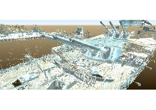
Image: A preliminary point cloud from HDS laser scans of the Battleship New Jersey. Image courtesy of Haag 3D Solutions, LLC.
A combination of HDS 3D laser scanning, high dynamic range photography and standard survey techniques are being used to create an accurate digital representation of the Battleship New Jersey.
NORCROSS, GA, August 20, 2014 – Leica Geosystems, together with Haag 3D Solutions, LLC, has embarked on a volunteer effort to digitally document the nation’s largest battleship, the Battleship New Jersey, anchored in Camden, N.J. The project is being undertaken in preparation for the upcoming educational seminar and 150th meeting of the West Jersey Chapter of the New Jersey Society of Professional Land Surveyors, which will be held September 10th on the battleship.
Four scanning teams are using Leica ScanStation HDS 3D laser scanners to complete the project. An additional crew has been assigned to concentrate documentation efforts on the interior of the five-story number-two gun turret, which was only just recently opened to visitors. The highly accurate, high-definition point clouds will be processed using industry-leading Leica Cyclone software, which will allow the teams to achieve efficient registration as well as to quickly extract relevant feature and coordinate information from the point cloud data. The teams will also be able to view and interact with point clouds using the free Leica TruView panoramic point cloud viewing software.
The results of the HDS documentation project will be used by the Battleship New Jersey Memorial Association as a historical record and for ongoing maintenance and educational purposes. There is also the potential to create a virtual tour for veterans and other individuals who might be unable to tour the physical battleship.
“We are very excited about this opportunity. Never before has the battleship been documented this accurately,” said Jack Willard, senior vice president of marketing and sales at the Battleship New Jersey. “Using this new technology will give us the opportunity to really showcase the number-two gun turret, with three-dimensional views and cross sections never before seen.”
Haag 3D Solutions, LLC, is a technology and services company specializing in the application of 3D imaging and BIM technologies delivering highly accurate and reliable as built documentation for both public and private sector clients. The firm, which has completed hundreds of 3D laser scanning and BIM assignments throughout North America, annually selects one non-profit historical structure to record and document visually for the public. Last year, the company digitally documented the Historic Barclay Farmstead located in Cherry Hill, NJ, using HDS laser scanning technology.
“Our firm is dedicated to reaching out and providing our technology and experience to the community we live in,” said Christopher Zmijewski, vice president of Haag 3D Solutions. “Having the Battleship New Jersey in our backyard provides a unique opportunity to completely scan the ship. We recognize how HDS documentation technology can be used to enhance future visitor and educational experiences, while documenting the ship as the engineering marvel she is.”
Leica Geosystems is providing additional HDS 3D laser scanners and technical assistance in support of the project. “For more than a decade, Leica Geosystems’ High Definition Survey scanners have been used to accurately capture the geometry of various large and compelling structures,” said Frank Lenik, technical sales representative for Leica Geosystems. “Leica Geosystems is pleased that our scanning solutions are being used to capture the historic Battleship New Jersey for the long-term benefit of the public and the ship’s custodians.”
Additional details about Leica Geosystems 3D laser scanning solutions can be found at http://www.leica-geosystems.us/. For more information about Haag 3D Solutions, visit http://haag3dsolutions.com/. For more information about the September 10th educational seminar being held on the Battleship New Jersey, visit http://novalearningnetwork.com/battleship-nj-seminar/.
A preliminary point cloud from HDS laser scans of the Battleship New Jersey. Image courtesy of Haag 3D Solutions, LLC.
Leica Geosystems – when it has to be right
With close to 200 years of pioneering solutions to measure the world, Leica Geosystems products and services are trusted by professionals worldwide to help them capture, analyze, and present spatial information. Leica Geosystems is best known for its broad array of products that capture accurately, model quickly, analyze easily, and visualize and present spatial information.
Those who use Leica Geosystems products every day trust them for their dependability, the value they deliver, and the superior customer support. Based in Heerbrugg, Switzerland, Leica Geosystems is a global company with tens of thousands of customers supported by more than 3,500 employees in 28 countries and hundreds of partners located in more than 120 countries around the world. Leica Geosystems is part of Hexagon, a leading global provider of design, measurement and visualization technologies that enable customers to design, measure and position objects, and process and present data.
For further information please contact:
Leica Geosystems Inc.
Andre Ribeiro
Vice President, Marketing and E-Commerce
Atlanta, GA 30092
Phone: +1 (770) 326-9557
Fax: +1 (770) 447-0710
[email protected]
www.leica-geosystems.us


