
Trimble SiteVision with a new 3D scan tool
Trimble SiteVision Software 5.0 is the latest version of the company’s high-accuracy outdoor augmented reality system, used to accurately place and display 2D/3D data in a real world context from any angle at true-to-life scale. Other key features include transforming complex 2D designs into visual 3D models, precisely locating and revealing hidden assets and combining Trimble Catalyst GNSS positioning with Google and iOS AR technology. More on the history of the system is available in this article.
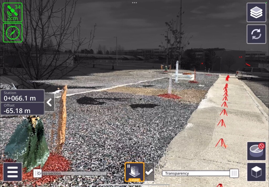
The latest version of Sitevision comes with a new 3D scan tool that allows customers to use lidar sensors available on some Apple Pro devices with the Trimble DA2 GNSS receiver to capture point clouds efficiently and accurately with a single handheld solution. Users can also visualize 3D scan data directly in the field with SiteVision’s augmented reality view. These scanning tools enhance SiteVision’s functionality for creating practical and accessible field-to-office workflows for surveyors, contractors, and engineers.
The new 3D scanning and lidar measurement features are only available with lidar-equipped devices, including the iPhone 12 Pro/Pro Max or later, and iPad Pro 2020 or later. Two spec sheets with more info are available here.
The Trimble TDC6 Handheld Data Collector is a lightweight handheld GNSS data collector for surveying and mapping. It allows contractors to work with more complex data sets more effectively in the field, connect to the office for on-the-spot approvals, and communicate changes to field crews quickly and easily.
The small, rugged device offers integrated Wi-Fi and Bluetooth, built-in cameras, and 5G compatibility in a lightweight, shock, dust and water-resistant package. The TDC6 integrates seamlessly with Trimble data collection applications, such as Trimble TerraFlex GIS software and Trimble Access survey field software, as well as third-party apps such as Esri ArcGIS Field Maps. More info, including a list of product specifications, available here. A spec sheet in multiple languages is available here.
Finally, the Trimble TDL450B Radio is a next-generation 450 megahertz external radio with Bluetooth for transmitting, receiving and repeating GNSS corrections. It provides flexible configuration options and rugged reliability for the efficient use of GNSS in a variety of applications. Designed to support Trimble and third-party RTK base stations, the radio modem puts Trimble’s newest data link technology in the hands of users on the job site. The TDL450B radio is an advanced, high-speed, wireless UGH data radio built to endure the stresses of daily use in harsh conditions. A user-friendly interface makes it easy to set up and configure, and access to diagnostic data in the field makes it easy to solve signal strength challenges and make adjustments when needed to avoid downtime. More info is available here, including a spec sheet in multiple languages.


