
Positioning and mapping leader’s Business Center v3.0 software lets surveyors produce 3D point clouds, DSMs
Trimble Navigation Ltd. on Wednesday debuted a new version of its Business Center office surveying software featuring photogrammetry enhancements, including the ability to process images from the Gatewing X100 unmanned aerial system (UAS).
The Sunnyvale, Calif.-based, publicly traded (Nasdaq: TRMB) company, with $2 billion in 2012 revenue, uses positioning technologies – GPS, lasers and optics – to focus on applications requiring position or location, including surveying, construction, agriculture, fleet and asset management, public safety and mapping.
Trimble said its Trimble Business Center version 3.0 helps surveyors, engineers and geospatial data managers increase their productivity, efficiency and quality of deliverables through the software’s increased visualization and aerial data processing capabilities.
Surveyors can produce aerial survey deliverables, including georeferenced orthophotos, 3D point clouds and digital surface models directly from the software.
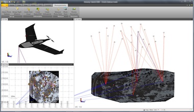
Version 3.0 introduces a new photogrammetry module for importing and working with flight data and images collected from the Gatewing X100 UAS and optical instruments, such as Trimble’s S8 and VISION technology, which integrates calibrated digital cameras to collect survey data, stream video from the perspective of the instrument and capture panoramic still images.
“Powerful and intuitive, Trimble Business Center and its integration with UAS data introduces new capabilities to surveyors and represents a significant leap in efficiency,” said Erik Arvesen, vice president of Trimble’s survey division. “Traditional sites, such as large mines, that in the past have taken days to map using conventional methods can now be accurately modeled in just hours.”
Based on its 30-year-old Inpho brand of digital aerial photogrammetry software, the new photogrammetry module also provides office surveyors with the capability to process complete mapping projects containing aerial data, GNSS and total station observations.
With the ability to integrate photogrammetry with data collected from GNSS receivers, total stations, and digital levels, surveyors can combine aerial images with GNSS measurements on ground control points and 3D laser scans of buildings to map large and complex sites.
The new version also introduces 64-bit processing to give surveyors in the office the ability to utilize their computer’s RAM, maximizing the productivity of the surveyor’s workstation, to display large images and point clouds for increased visualization functionality.
Users can also display large images seamlessly; images “tile” automatically on import and the displayed resolution adjusts seamlessly as users zoom in and out for superior image viewing.
“Inpho is a proven leader in digital aerial photogrammetry,” said Arvesen. “Trimble has taken that expertise and applied it to the survey market, as we pioneer the development of UAS data integration for surveyors.”
Trimble Business Center Software version 3.0 and the photogrammetry module are now available through the company’s Survey Distribution Channel. Business Center version 2.9 is also available for users who are limited to 32-bit systems.


