
Oregon State’s Olsen to lead project, deliver results in 18 months
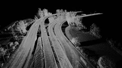
WASHINGTON – The Transportation Research Board, one of the six divisions of the nonprofit National Research Council based here, awarded last week a $250,000 grant for the establishment of “Guidelines for the Use of Mobile Lidar in Transportation Applications.” Michael Olsen, assistant professor of geomatics engineering at Oregon State is the principal investigator, leading a team of 12 transportation and laser scanning veterans and grad students.
The objectives of the project, said Olsen in an interview with SPAR 3D, essentially boil down to educating departments of transportation about the availability and capabilities of mobile laser scanning; a development of guidelines for the contracting and evaluation of laser scanning jobs; and then making those guidelines available to the transportation community at large.
“Lots [of DoTs]are using terrestrial scanning,” Olsen said, “but there are limited amounts of people with access to mobile scanning, so we’re first trying to educate them about how that technology can help them.” It’s impractical to think departments would be comfortable contracting for such services, Olsen continued, before they have some idea of quality control and how to insure the data collected is to universally agreed upon standards.
One of the first steps Olsen and his team will undertake is to create and distribute a survey that will set a baseline for current applications of mobile scanning. It should be available in about two months.
Olsen said it was largely the strength of his team that won him the grant. It consists of:
• Craig Glennie, Olsen’s co-primary investigator, of the University of Houston, assistant professor of civil and environmental engineering, and of electrical computer engineering, and part of the National Center for Airborne Laser Mapping and former VP at Terrapoint.
• David Hurwitz, assistant professor of transportation engineering at Oregon State. Olsen said he brings “familiarity with how DoTs work and how they can integrate this into their workflow.”
• Mike and Beth Knodler, from Innovative Data, who are focused on transportation data collection, based in Massachusetts.
• Fred Persi, head of Persi Consulting and a member of the ASTM International Committee E57 on 3D Imaging Systems. “He’s an expert in data management and developing computer programs to handle the data,” Olsen said.
• Marcus Reedy, VP of surveying and geomatics at David Evans and Associates, and Anthony Squellati, who handles mobile laser scan collection and processing for David Evans.
• Gene Roe, editor of Lidar News and a member of the ASTM International Committee E57 on 3D Imaging Systems.
• Keith Williams and Halson Tuss, who are graduate students in the geomatics and transportation fields at OSU.
“Each person has a different background,” Olsen said, “and that’s what helps with the project. They’ve all got their own expertise.
At the end of the project, which has a targeted completion date of March 14, 2013, but will probably be done sooner than that, Olsen hopes to have a set of guidelines that allow for the latest technology to be creatively applied, and won’t hamper progress.
“We don’t want to turn this into ‘This is what the contractor has to do,’” Olsen said. “We want the guidelines to be flexible and not an impediment to the workflow. It’s more quality assurance that the DOTs can use, so they feel comfortable. The contractors can attain the accuracy any way they want. The idea is that you don’t want these guidelines to be technologically specific, because then they’re outdated a couple days after you release them. It all just goes back to the quality of the survey.”


