
David Evans and Associates contribute a Titan-ic effort
LOS ANGELES – There were a couple of live video feeds that dominated Internet attention this past weekend: One involved a guy falling 128,000 feet out of the sky; the other involved a space traveler that would never fall from the sky again.
Thanks to good planning, both safely arrived at their destination. Felix Baumgartner and the Red Bull Stratos team began their planning in 2005 and it resulted in a safely completed jump from the upper atmosphere (calling it “space” is slightly disingenuous). Similarly, Cordoba Corporation and David Evans and Associates began planning the move of the Space Shuttle Endeavour from LAX to the California Science Center in Exposition Park back in August of 2011 and it resulted in the Shuttle arriving at the Science Center without a single piece of damage – though it was about half a day later than originally planned.
Not bad for a move of a 175,000-pound object 15 miles (see a time-lapse video of the actual move here). Some sensationalist news outlets, like ABC News, called the move “a nightmare,” but as you’ll see in the following video, nothing actually seems to have gone wrong:
Thank laser scanning for that. David Evans and Associates had worked with Cordoba previously on a light rail project and California survey manager Bob Vasquez got a call from them one day last summer. They had agreed to help with the engineering of the Shuttle move and they knew they needed some help.
“They needed to know if it was feasible or not to go down the route they had selected,” Vasquez said. “They said, ‘We think this is the perfect job for that mobile scanning thing you’ve got.’ They said, ‘It’s going to help move the Space Shuttle. It’s going to be great.’”
Of course, there was no budget. David Evans would have to do the work out of the goodness of their hearts and for the resultant marketing benefit. In the end, it wasn’t a tough call. It was the Space Shuttle.
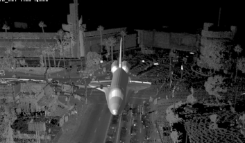
So, DEA deployed their Titan mobile scanning system, a unit they’ve had since buying the system in 2008 from Ambercore Software, after contracting with Terrapoint for a year.
“What they needed to know,” Vasquez said, “is whether the system could identify the potential conflicts along the route that they chose, and what are the impacts given the width and height. We said we could do that – we’ll take it to 90 feet wide and 60 feet high and see what we have there.”
But that was easier said than done. DEA had to invent a way to do clash detection with an introduced surface model into 12 to 15 miles of point cloud data. “We could do surface to surface,” he said, “but not surface to point cloud.”
DEA’s internal team went to work and developed a workflow that involved a cutting plane extruded throughout the entire path of the Shuttle, ending up with a polygon through the entire area. Then it was simply a matter of looking at what’s interfering, cross section by cross section.
There was plenty of obvious stuff: Overhead street lights and utility wires, buildings, and the like. Other objects, like small trees, were more difficult.
But “we were able to extract the point data that way,” Vasquez said, “and presented the list of points at the team meeting. That was a jaw-dropping experience. No one thought there would be that many utilities in conflict – some of them were major transmission lines. Sure, you can cut cable and TV for a little bit, but what about major power transmission lines?”
This weekend, they cut major transmission lines. Some areas of Los Angeles had significant periods of time with no power.
Also, jaw-dropping, however, was the simple act of the mobile survey itself. How would DEA have done the work without a mobile scanning system?
“Everything would have been survey-grade labor,” Vasquez said. “Everything would have been basic total stations, or pulling tape, it would have been very labor intensive … In the old way, with a good team, we could do maybe 1,200 feet a day, and that’s just grabbing utilities. That’s not topo-ing the buildings, which might be something like 500 feet a day. Their parameter was everything eight feet off the ground and higher, they wanted to know what’s in conflict. That would have taken forever. Maybe a whole year.”
Instead, they did the collection in one day.
Speed wasn’t the only benefit, though. There was an important need for secrecy. No one wanted the path of the Shuttle move broadcast ahead of time.
“No one in the public knew we had even done the scanning until about three weeks ago,” Vasquez said. “Had we been doing it the old way, the public would have been like, ‘Hey, what are you doing?,’ and all hell would have broken loose. That’s benefit of being with the flow of traffic; no one knows you’re there.
“And in LA, too, they probably thought it was a movie project or something. They don’t even pay attention.”
When the Shuttle came rolling through, though, that got their attention.


