

February 16-18, 2026 | Colorado Convention Center | Denver, CO, USA **Early Bird Pricing Ends 1/16**Join Us at Geo Week 2026!
But this innovation is not limited to private companies or a trade show floor - there are innovative projects happening at universities across the globe. From advanced techniques for mapping the previously unmappable to training the next generation of geospatial scientists, universities offer a unique opportunity for innovation.
At Geo Week 2023, the Academic Showcase featured posters from some of the leading geospatial programs at universities and colleges.
Students from Embry-Riddle Aeronautical University, for example, set out into the desert of the American Southwest to try and discover evidence of previous civilizations that falls between the resolutions of traditional ground-based archaeology and the resolution of images provided by satellites. By using a UAV-mounted lidar, the students were able to capture evidence of new features at previously worked archeological sites - leading to new insights about the previous inhabitants at sites dating back to 5,000 years. At the Academic showcase, students also shared a VR representation of one of their drone flights - putting the wearer in the perspective of the drone.
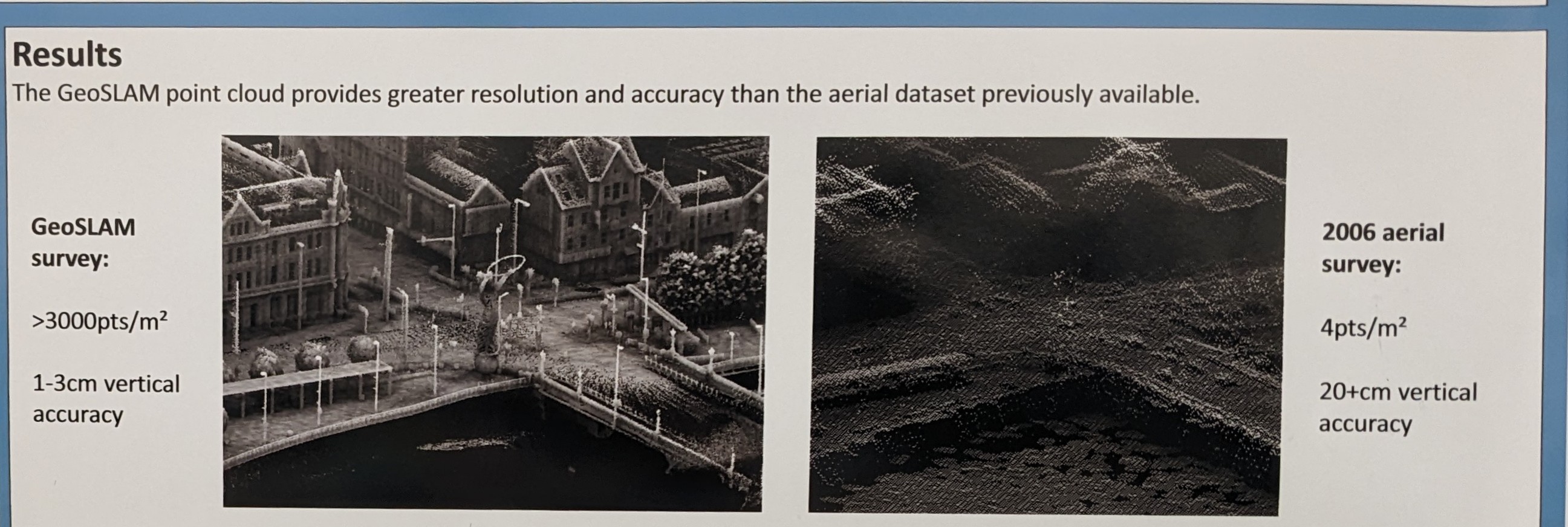
Turning to an environmental challenge, Queens University researchers are working on a project to identify new workflows for mapping urban areas that are vulnerable to flooding. The challenge - underground portions of buildings are rarely mapped. By using a GeoSLAM scanner on foot, they were able to pilot a process to capture information that could be used to directly or indirectly buildings with subterranean structures, which has the potential to help officials to create better flood maps.
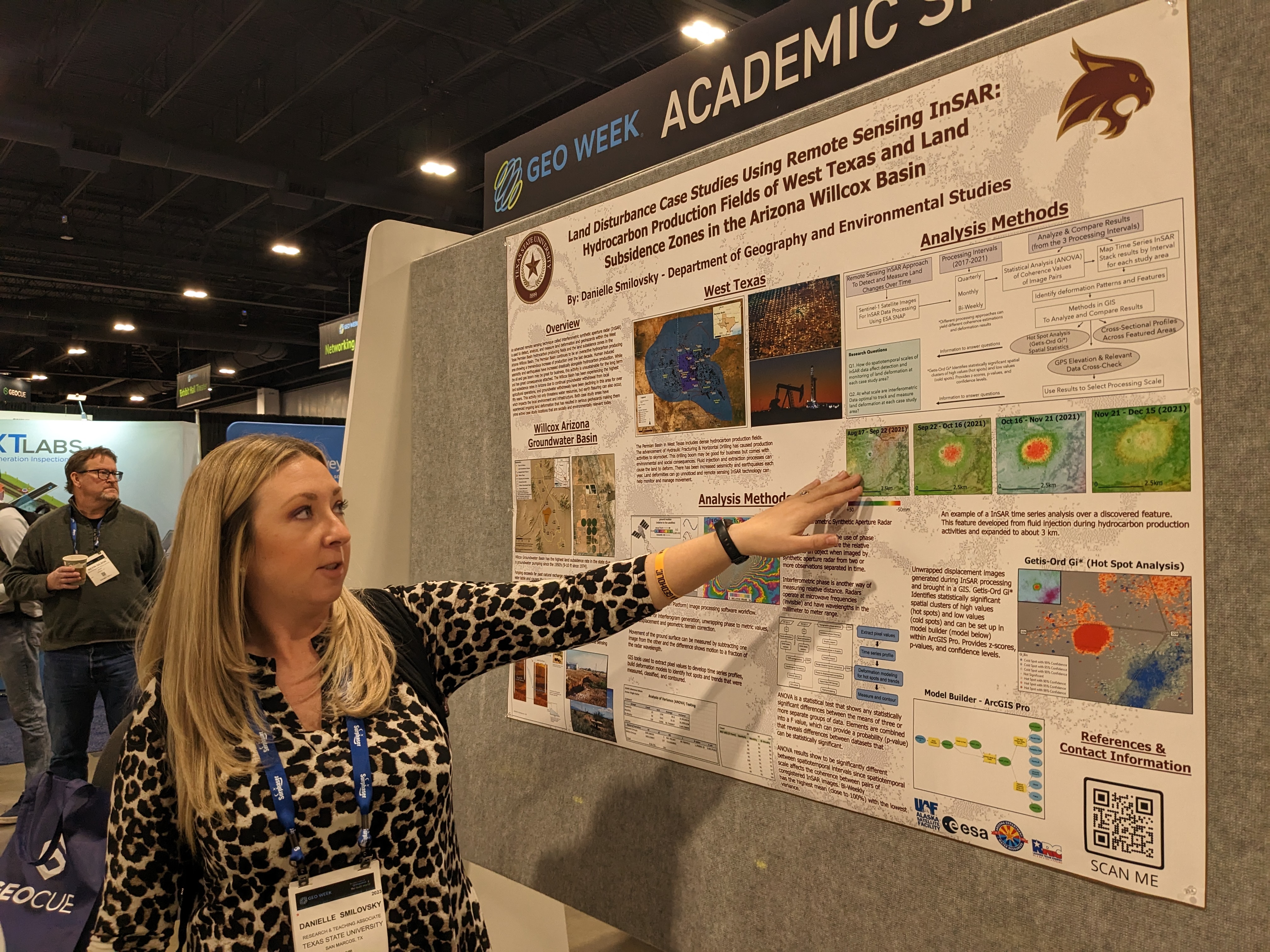
Presenting from Texas State University, Danielle Smilovsky presented on her utilization of remote sensing Interferometric Synthetic Aperture Radar (InSAR) to identify land disturbances. Her work highlighted cases in two locations: Oil fields in West Texas and the Arizona Willcox Basin. Smilovsky explained to Geo Week News that this crucial information detected from satellite imagery focused on groundwater extraction in Arizona and hydrocarbon production in West Texas, noting that these changes, which can result in things like Earth fissures, are difficult-to-impossible to detect on the ground but can be seen by comparing multiple satellite images. While collecting this data was once prohibitively expensive, accessibility has grown by leaps and bounds, meaning this promising technology could be used in more areas around the U.S., and the world.
Every surveyor has heard of photogrammetry and lidar, but not all understand the costs, benefits, pros and cons of each system. Many larger surveying firms have already invested in one or both of these systems, but smaller companies have been left behind. The purpose of a project from Ferris University was to develop a comprehensive report comparing results and costs between conventional topo, photogrammetry, and lidar, then present the results to give real world information to those who might be considering purchasing one of the systems. To accomplish this, a 10 acre area with varying terrain and features was surveyed with conventional instruments, an Inspire 2 drone, and a M300 drone with a P1 camera and a Zenmuse L1 lidar sensor. The results and costs are to be compared and contrasted.

At Oregon State University, students have access to a brand-new laboratory equipped with the lates survey, terrestrial, laser scanning, robotics, UAS/UAV lidar and even hydrographic survey and sonar equipment. A unique site in Wilammet Falls provides the training ground for students learning new techniques. Tumwata Village (formerly known as Blue Heron Paper Mill) located by the Willamette Falls in Oregon City, Oregon has a very intriguing history and was recently purchased by the Confederated Tribes of Grand Ronde with the intent to restore the falls to their natural state and preserve some of the oldest structures. In survey “boot camps” students covered the area with many techniques and tools including the latest in drone tech, which can provide data for future uses of the site, as well as being a hands-on teaching experience.
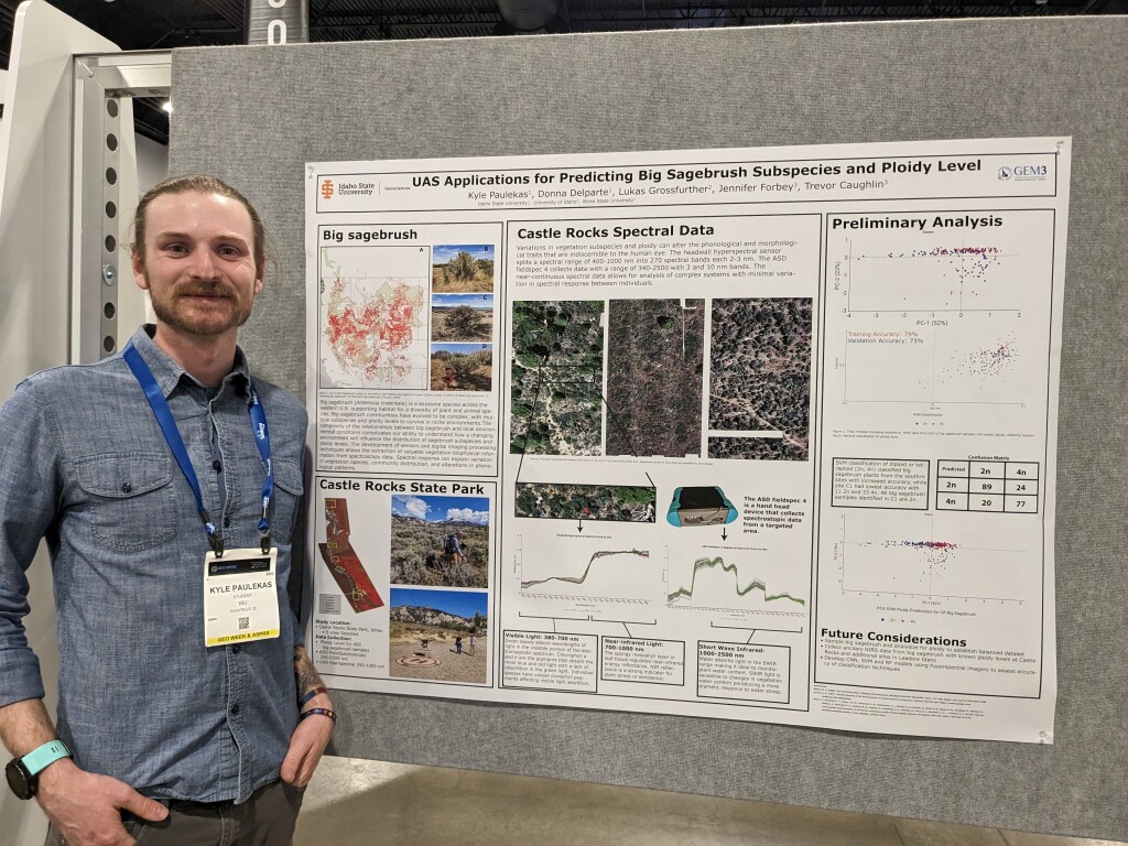
The applications of drone-captured data are not limited to lidar surveys, however. Researchers from Idaho State University are utilizing UAS to capture some surprising information about the plants and ecosystems there. While plant species can look very similar to human observers - in this case, very similar-looking scrub brush species - it can be difficult to tell their characteristics, and match what specific species are growing in different ecosystems. With the help of hyperspectral data captured by drone, the researchers are now able to not only determine differences in species and hybrids, but other genetic differences that signal reproductive characteristics.
The next generation of surveyors, geospatial professionals and innovators are already on the move. Read more about their projects in the academic showcase.


