
Post-hurricane, time is of the essence
PRAIRIEVILLE, La. – As Hurricane Isaac approached the Gulf of Mexico and its many offshore platforms, Tesla Offshore was preparing for the worst. As a geophysical contractor with clients all over the Gulf, the company was ready to help identify damaged platforms, examine compromised pipelines, do whatever it took to get the petroleum companies back to business.
Part of that preparation meant making sure everything associated with the company’s two EchoScopes – real-time underwater 3D sonar scanners – was in good working order.
Luckily, they weren’t needed. “I had one guy tell me it was only like a large thunderstorm,” said C.D. Schempf, Jr., senior VP of sales and marketing with the 100-person firm. “One guy lost a ladder. Another lost some tires off a boat landing. But nothing major. That doesn’t mean that the platforms weren’t damaged at all, just that there wasn’t a lot of underwater structural damage. A lot of platforms are still shut in due to damage onshore.”
For that, plenty of people are very thankful. But during a wide-ranging interview with SPAR, Schempf and operations manager George Loy had some interesting things to say about EchoScope’s utility and how they’ve used it in the past. And, since Tesla owns the second EchoScope ever made commercially available (serial number 8), plus another bought shortly after (serial number 17), few companies have more experience putting the equipment to work.
Those purchases were made not long after the twin tyrants of Katrina and Rita blew through the Gulf, leaving a trail of damage in their wake.
“With the EchoScope, the main thing is that you can get spatially correlated data in a very short time,” said Loy. “You can take two or three scans from two or three angles and have a good idea of what you’re looking at.”
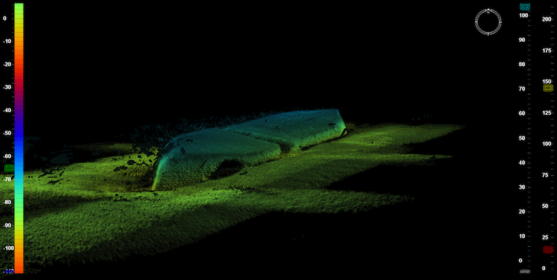
You can see in the following images the kind of data that can be collected:


Other systems require bringing the data into a back-office environment and processing the data before you can make use of it. With EchoScope, it’s both real-time and 3D. This can be important in a situation like after a hurricane where you have to go to a lot of places safely and in a quick amount of time.
“We can put it on a tripod and if we have USBL positioning, we can move around a structure offshore and be done in about an hour. It might not be real high-resolution scanning data like you’d get with a terrestrial laser scanner, but you’ll know if there’s a broken leg or things hanging off underwater, how far off the bottom it is, where it is, that kind of thing. You can do things really quickly in real time, where some other sonars might give you a prettier picture, but it takes more time and it’s got to be perfect.”
“The drawback,” Loy continued, “is that you have to have pinpoint positioning. It’s not like a terrestrial laser scanner where you sit completely still while you can survey that point. That’s not easily done in a marine environment, especially with a boat that’s moving.”
That’s why Tesla sets an in-house-developed subsea manipulation tripod on the sea floor whenever it can, and uses ROVs only for jobs where that’s impractical. Also, Tesla has made proprietary modifications to the cone of collection to help maximize the EchoScope’s effectiveness.
Keeping that tripod still isn’t as easy as it sounds – and it’s vitally important. “Things won’t line up if it’s not perfectly still or controlled as you’re doing the scan,” Loy said. “Imaging doing that in eight-foot seas. You have to know all of your offsets and be on top of a lot of things to get the best benefit out of the technology. We conquer all of those things and we can provide our clients with information that’s invaluable in a time of critical need.”


