
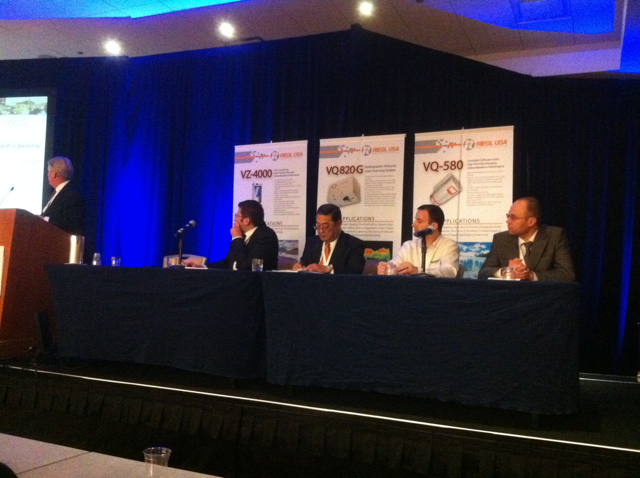
Panel at Riegl conference explores the future
ORLANDO – While much of the first day of the inaugural Riegl Airborne and Mobile Scanning User Conference concerned the concrete how-to of operating Riegl systems, one of the more well received portions of the day involved a panel discussion looking toward the future of surveying and the role that laser scanning and 3D imaging might take in that.
Moderated by Riegl USA president Jim van Rens, the four panelists each took about 10 minutes to at least glance into their crystal balls and hazard a guess as to where technology is taking the industry, and what the industry needs to do to keep up with where technology is headed.
Perhaps the most willing to walk out onto a limb was Ilya Rylskiy, chief of the remote sensing data department at ARKON, based in Russia. Gripping the sides of the podium as he soberly addressed attendees, he sketched out a number of possibilities that had people buzzing through the rest of the day. Flash lidar, he said, could soon be a player, inexpensively challenging current lidar systems by going well beyond the half a million pulses per second where most flash systems now max out.
And sensors will be integrated, he predicted. “At 1,650 nanometers, a laser beam can also be used for finding the gas coming out of a broken pipeline,” he said. “Right now, that solution exists, but it’s separated from lidar. A mixed gas analyzer and lidar could be more powerful and productive for consumers.”
Lasers will become faster and more powerful, too. “They will reach five megahertz,” he said. “You could do laser scanning from 20 kilometers with very high density.” Coupled with solar powered aircraft that may soon exist, essentially staying aloft indefinitely, what’s to stop lidar on demand, requested via the internet?
Finally, he said, the price reduction in GPS receivers, IMUs, and laser scanners, coupled with an inexpensive UAV like a quadricopter, could result in aerial scanning systems created for something like $20,000. “You’ll see that lidar will start to come into private life,” Rylskiy said. “There could be a revolution in collection methods.”
On this last point, Rylskiy was building on ideas put forth by Joe Hutton, director of airborne products at Applanix. Most significantly, in eight years we’ll have “full constellations of modern GPS,” he said, including L5, along with Galileo (the European Union’s GPS equivalent) and Compass (China’s BeiDou satellite program). “You’ll have up to 60 satellites in the sky at any time,” he said, which will result in and require 220+ channel receivers.
“You’ll be able to do real-time, multi-frequency IAPPP via satellite uplink,” he predicted, providing “centimeter-level robust positioning in real time.”
Further, he said, “MEMS [inertial sensors]will be everywhere.” They are much cheaper than fiberoptic options, he said, and “you’ll see automatic aiding of imagery and lidar right into the processing. You’ll have it together to essentially do point matching as feedback when you lose GPS … You’ll be able to use the geometry to help the inertial solution.”
This will be vital, said Christian Briese, of Vienna University of Technology, because “what we can already see is that we’re moving from static observations to kinematic observations, something that’s very important for the future.”
The need for conservation of resources in the future, he predicted, will increase the need, too, for multi-temporal acquisition, documenting environmental changes precisely “in order to predict the status of the environment in the future.” To make this more practical, though, he said the industry needs “direct georeferencing” and a much fine-tuning of the process of calibration and the scan-to-deliverable workflow.
Dennis Hirota, head of Hawaii’s Sam O. Hirota Inc., was of a mind with an attendee who questioned the panel about whether scanning would be involved at all. Hirota showed off a pavement documentation and examination workflow he’s developing with earthmine all done with photogrammetry that results in navigable 360-degree images from which you can take measurements accurate to within a couple of inches.
“The big advantage is that the images have very good quality,” he said. “You can pan and zoom and the positional accuracy is good enough for what the city wants to do, which is improve the GIS database, which has terrible positional accuracy.”
“My effort in the near future,” Hirota said, “will be in looking at lidar plus photographic imaging.” He noted Darpa’s recent MIST workshop, where the organization looked to explore “technologies like computational imaging, synthetic-aperture imaging, digital holography, multi-static laser radar, and angle-resolved imaging based on light transport analysis.”
Clearly, said Hirota, “the government is going to be putting big time money into that going forward.”
However, Hirota also predicted that “the bigger market is the interior space,” where both lidar and photogrammetry could provide valuable solutions. He’s also a believer in the growth of ground penetrating radar.
Of course, the future remains relatively opaque to just about everyone. But taking guesses at the industry’s direction could pay big dividends, as noted by van Rens.
He said the USGS has stated there is a potential for creating some $1.2 billion in annual efficiencies with the use of lidar technology. Markets like flood-risk management and precision farming have already been identified as potentially big new opportunities. But the what and the how aren’t necessarily always obviously linked.
Looking back on the 10 years leading up to the present day, van Rens said, “the markets we thought would emerge, did emerge. How they actually arrived, however, was totally different than we thought.”


