Though AEC(O) was once relatively slow to adapt to new technologies, you’d never know it by looking at the industry in 2018. As large firms have seen their customers demand ever faster, more accurate, and higher-quality work, these firms have started taking to cutting-edge technologies like augmented reality to increase their competitive advantage. The same can be said for facilities managers—to a point.
“Except potentially for large scale scale organizations such as universities,” explained Steve Voller, founder of Altuity Solutions, “the education sector hasn’t seen the innovation in buildings and asset management that has applied to other sectors.” That’s why Altuity teamed up with University of Bristol for some R&D that will bring AR and other new technologies to this underserved market.
 AltoSites: meta-AR for facilities management
AltoSites aims to solve this problem by developing an affordable, intuitive way for facilities managers in education and estate management to bring Google StreetView functionality into their buildings. The workflow is designed to be powerful enough to meet their extensive needs, but straightforward enough not to scare off potential users, which could include bursars, school business managers, and even teaching staff.
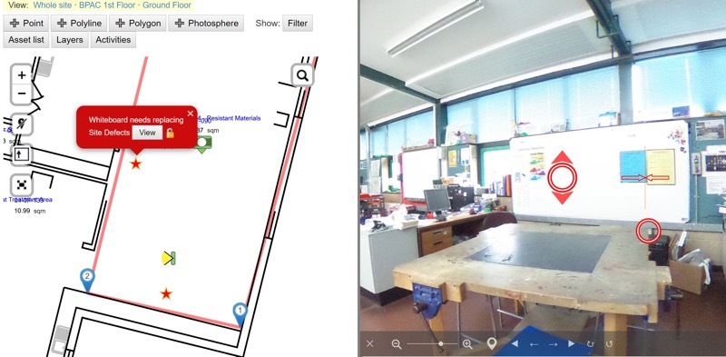
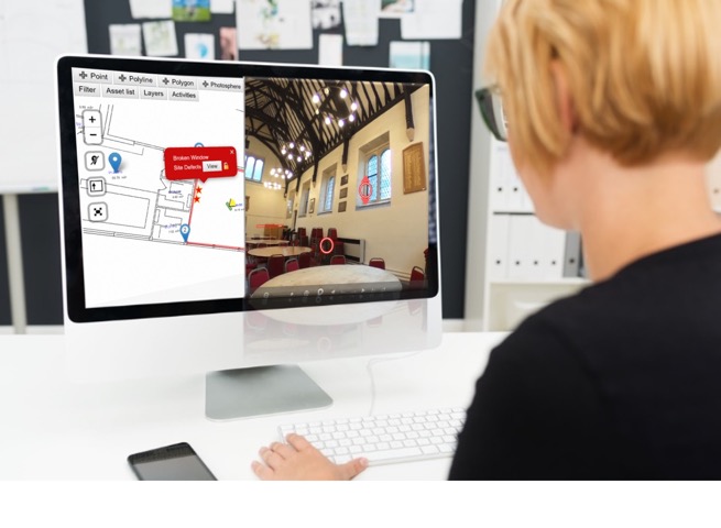
Here’s how it works. Users carry a 360° camera like a Ricoh Theta and capture photospheres of the site they want to document. After gathering enough spheres to ensure full coverage of every room, they upload these captures to AltoSites and associate them to the matching room on a floorplan. From there, AltoSites will identify the room’s edges, and match them against the photosphere.
The QA process is just as quick. The user views the floorplan using AltoSites, where she will see calibration markers that show where AltoSites thinks the walls and corners are. After she adjusts the markers manually to ensure a tighter fit, the photospheres and the floor plan are tied together.
After that work is done, users can enter a room and hold up a mobile device like an iPad, and AltoSites will bring up the pre-captured photosphere aligned with the real world, complete with important FM information for all available assets. For instance, a teacher using this “meta-AR” display, as Voller calls it, can hold his iPad up to a boiler, and see all associated asset info or maintenance requests, or even add his own maintenance requests without any knowledge of complex FM software.
A step back from the cutting edge
Why an iPad, I ask? Why not something with more buzz, like a HoloLens? “To improve reliability and ease of use,” Voller says, explaining that some of the flashier AR technology isn’t reliable enough for use in these markets. “A partly baked solution isn’t going to work in our market, no matter how sexy the tech,” he adds.
When Altuity has shown this affordable but reliable solution to “a select group of existing schools,” he says, the reaction has been quite good. “The ease of use and immediacy of accessing and understanding data is extremely important to them.” For the first time, many smaller school facility managers, or estate managers, can open up a plan and get a quick understanding of a remote building. Teachers can put in maintenance requests quickly, and check the status of those requests just as quickly. Schools can generate immersive tours for marketing purposes, or to help explain proposed changes to a board of directors that will determine funding.
“It fulfills a need the market doesn’t know it has,” says Voller.
Where did the money come from?
To help develop a solution for this market, which doesn’t have the money flowing into it that you would see in AEC, Altuity and the University of Bristol applied for a grant from Innovate UK, the “UK’s Innovation Agency.” The agency “drives productivity and growth by supporting businesses to realize the potential of new technologies, develop ideas, and make them a commercial success.”
With the grant money from Innovate UK—who takes no stock in the resulting product, by the way—Voller and his colleauges were able to develop a tool that is effective, but forward-facing.
“Coming from a road asset management background,” he says, “using spatial interfaces myself and then having exposure through Bentley to the design part of asset management, I thought—there’s a great opportunity to introduce this integrated tech, in an operational environment, to the education market. There, it’s been overlooked, or the users couldn’t afford the investment level of enterprise systems, which are probably over-scoped for their needs anyway.”
Next steps
Now that the foundation for this solution has been set by Altuity, Bristol, and Innovate UK, new innovations will be coming along, too.
Voller tells me that the team will add visual feature recognition technology to help with asset collection, as this will “enable asset data to be automatically collected” from the photospheres—saving significant on-site data entry costs. BIM and VR integrations are also in the works, and Voller says they are keeping an eye on indoor localization technologies, which could enable the solution to combine indoor navigation with operate and maintain processes. The company also plans to release the technology for commercial users, particularly in small to medium size facilities.
For more information, check Altuity’s two blog posts about the R&D process for AltoSites.