
SPAR 2009 welcomed 633 attendees from 27 countries to Denver, Colorado last month, some 37% for the first time. Attendance shifted towards civil, transportation and building infrastructure segments, no doubt a consequence of depressed energy prices which has slowed project work and curtailed travel and training budgets in the industrial plant and oil and gas sectors. Despite a brutally tough economy, attendees were upbeat about the prospects for the industry and many of the attending firms seized the opportunity to get a leg up on their competition with investments in new hardware, software and training. Exhibitors reported that attendees were highly motivated and actively engaged.
Many attendees arrived pre-conference for the inaugural, standing room only 3D Laser Scanning Boot Camp presented by a subcommittee of the SPAR 2009 Advisory Board. More than 160 surveyors, plant project managers, CAD technicians, engineers and other disciplines absorbed the fundamentals of laser scanning in various market applications. Current feedback—and our goal to offer basic training on the technology—leads us toward offering this session again next year.
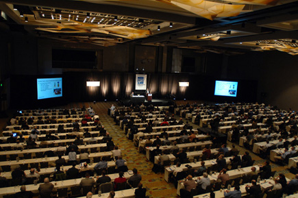
Keynotes Deliver Inspiration, Opportunities
On Monday, March 30, six riveting keynote presentations set the pulse for the conference. Our own CEO Tom Greaves highlighted the diversity of the market in terms of disciplines and application areas, all of which are linked by the ability to “capture, store, index, model and annotate 3D data [that]yields significant economic and security benefits to our society.” This rapidly changing market, Greaves said, includes new technologies, integrations and applications that provide a bigger footprint in the industry at-large. A case in point is the availability of $200 DIY scanners, such as the David Scanner demonstrated by his 15-year-old, Ian, in the exhibit space. Innovation, Greaves asserts, creates both wealth and security sorely needed in today’s difficult economy.
Next up, Hans Hess, of Hanesco AG, highlighted the nature of geospatial technologies becoming ubiquitous in our world, and how the innovative trends of faster, integrated and even multi-spectral scanning will open new application areas as well as help to aid investments in transportation and energy infrastructure, education and tourism.
Attendees were certainly stimulated by the GSA’s Charles Matta’s talk on the many immediate multi-year, multi-million dollar opportunities to provide scanning services for IDIQ BIM contracts to upgrade federal buildings. The GSA has found scanning to be faster, safer, less expensive, non-invasive in occupied areas and more efficient with ¼-inch spot verification. Opportunities abound for scanning professionals.
Dan Livecchi, of the U.S. Secret Service and IAFSM, dazzled our audience with details of cost, schedule, and safety and security aspects related to laser scanning capabilities for special events requiring federal protection. Buzz from his presentation continued throughout the conference.
John Copple, Sanborn CEO, discussed the broader impact of how rapidly evolving, converging technologies enable a new range of capabilities and applications; the reciprocal relationship between users, customers and suppliers in the market necessary for advancing products and services; and the much-needed support for education and standards in the industry. He remarked that trade conferences like SPAR and strategic partnering are two keys to advancement.
Nelly Robles Garcia, of the Archaeological Zone at Monte Alban, demonstrated numerous examples of digital heritage preservation applications and expressed the need to think of historical sites as requiring conservation, not just analysis. Scanning supports these goals.
Mobile, Data Conversion Red-hot
Over the following two days, attendees took in multiple presentations in tracks on industrial plant, mobile surveying and mapping, forensic and security planning, civil/transportation, nuclear facilities, BIM validation and integration, managing and leveraging geospatial information and digital heritage preservation, among others. Kicked off by Mandli Communications CEO, Ray Mandli, the Mobile Surveying and Mapping track was red-hot and supplemented by exciting exhibitor products. Minutes after arriving at the Hyatt Regency Hotel in Denver, Optech secured a VRS reference base station on the roof of the Hyatt Regency Denver for its demos. Trimble, earthmine and Optech (via WHPacific) demonstrated mobile systems from the parking roundabout. Later in the show, Terrametrix announced its establishment as the official North American distributor of the StreetMapper system under a joint venture with StreetMapper’s maker 3D Laser Mapping and GeoDigital International.
Other notable solutions were demonstrated by two sponsors, ClearEdge 3D and Pinpoint 3D, and presenter Zebra Imaging. ClearEdge 3D’s EdgeWise automatically converts point clouds to 3D CAD, GIS and BIM models; read a brief synopsis by SPAR sponsor V1 magazine by clicking here. Pinpoint 3D’s ZipLine product automatically exports point cloud data into clean, accurate usable form. The software is free, but modeled export data is charged per scan no matter the number of points. Zebra Imaging offers a product that attendees call just plain “cool”: 3D visual communication holographic technology for topographic and architectural applications. Their hard copy 3D physical models allow users the ability to walk around a site and get detail into it in order to map terrain, visualize designs or illustrate prototype models, among other things.
Other presenter highlights: Ford’s Don Deming and Pointools’ Faraz Ravi delivered a stunning presentation of how point clouds could be segmented and then animated for production line conversion projects. HKS’s Pat Carmichael had jaws on the floor with a presentation that started with point cloud data and ended with extremely high performance, i.e. game-engine quality graphics for BIM applications.
SPAR 2009 was supported by more than 50 sponsors. Here are some highlights from a few of them.
Optech introduced its new Lynx Mobile Mapper V200 with increased LiDAR measurement rates, increased resolution, longer ranging capabilities and versatile options that allow for customized surveys, and its ILRIS-HD High Density scanner, which has an increased laser repetition and true measurement rate of 10 kHz and four times the speed.
FARO demo’d its Scene software, which exponentially accelerates scan registration over manual methods via fully automatic target identification and scan placement. Version 4.6 will be available in Q2, as will the Photon 120 and 20 laser scanners, which offer measuring rates up to 976,000 points per second, intelligent point discrimination for sunlight and edge definition, and an adjustable speed control balance. The 120 model claims an operating range up to 153 meters in dark and 120 meters in cloudy conditions.
Trimble’s PPP customers were presented with an increased range up to 46 meters and increase scanning speed of up to 190,000 points per second in the Trimble FX scanner and Trimble RealWorks v6.4 with a new plant module that includes automatic pipe extraction and modeling and export to AVEVA PDMS. The Trimble VX Spatial Station is now offered as a camera-only option scalable to full scanning capability, and the VX Spatial Station is being combined with a Trimble IS Rover for simultaneous scanning and GNSS data capture.
Leica Geosystem’s HDS6100 announced in February was on demonstration as well as the company’s new Cyclone II TOPO 1.1 software, which offers a 200-percent increase in speed in addition to the new SmartPick feature, which automatically selects particular points within a specified grid over a large area for deliverables. The new version will also automatically export 2D and 3D line, point and text data to DXF format.
Supplementing the recent introduction of the Z+F IMAGER 5006i laser scanner is the development of the Z+F AutoTarget. Based on Z+F PaperTargets, identical points are automatically detected in point clouds, accelerating data evaluation by up to five times. This automated registration process supports total station data and bundle adjustment for georeferencing, and avoids missing data in the field.
Intergraph announced that its SmartPlant 2009 SP1 now ships with the capability to directly access as-built laser survey data by partners CSA, Leica Geosystems, Quantapoint and Z+F for reference, measurement and modeling, which provides in-context, clash-free design.
Riegl announced TopoDOT, a solution for processing 3D image data in MicroStation. The software is offered through a new entity called Certainty 3D (C3D).
INOVx introduced its INOVx Certification Program for partners in which firms are certified in integrated laser scanning and photogrammetry technologies for asset management services, and trained on INOVx software, standards and procedures.
We’ll be digging into the tracks and sessions presented at the conference in future editions of SparView. We know there are many more stories and cases than these and encourage you to contact us to share your experience. We’re already scouting for SPAR 2010 presenters.
DISTINGUISHED EXPERTS HONORED
Spar Point CEO Tom Greaves was pleased to present this year’s SPAR Distinguished Achievement Awards following his opening remarks. Industry icon Hans Hess and CSA’s notable Amadeus Burger were presented with awards for advancing engineering and construction technology and work processes in the laser scanning arena. Clearly surprised, Greaves was presented with an award from NIST’s Alan Lytle on behalf of the ASTM E57 Committee on 3D Imaging Systems for his support of the industry.


