Researchers from the University of Science and Technology of China developed a new single-photon airborne lidar system for acquiring high-definition 3D images. The results were shared on multiple scientific websites earlier this month, including Optica Publishing Group’s journal for high-impact research, Optica, and SciTechDaily.
While traditional lidar systems use detectors that register multiple photons to measure distance and create a 3D representation of the scanned area, single-photon lidar uses a highly sensitive detector that registers individual photons that are reflected off surfaces in the scanned environment. The ability to detect individual photons enhances the accuracy and resolution of 3D maps.
Although single-photon lidar technology is still relatively new compared to traditional lidar systems, ongoing research and development efforts aim to address some of the challenges associated with the technology, such as a lower signal-to-noise ratio compared to traditional lidar and a limited range. Using the system on resource-limited systems such as drones and satellites also requires limiting energy consumption and shrinking the entire system.
Research team member Feihu Xu from the University of Science and Technology of China explained that the research team was able to incorporate recent technology developments into a system that, in comparison to other state-of-the-art airborne lidar systems, employs the lowest laser power and the smallest optical aperture while still maintaining good performance in terms of detection range and imaging resolution.
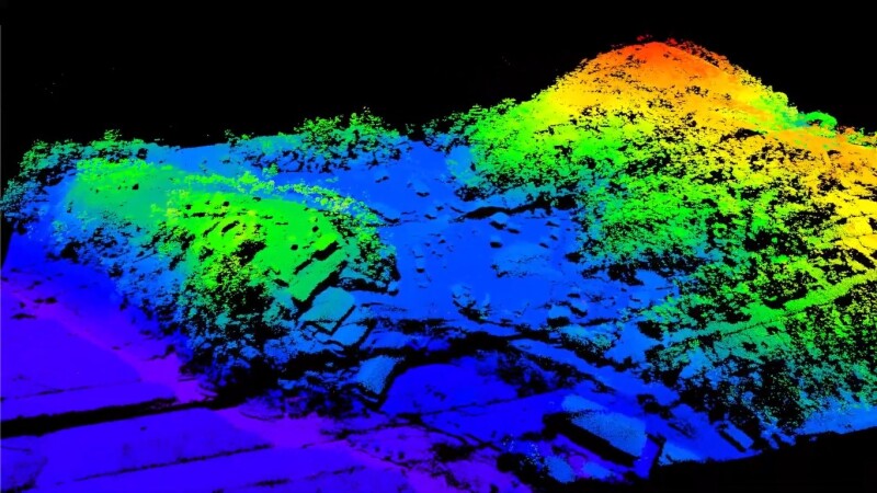
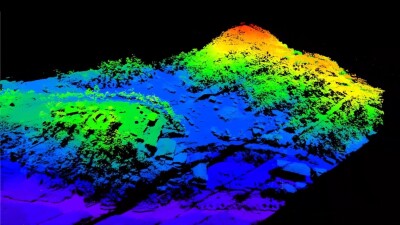
A short video gives an impression of the 3D map created with the system. A series of tests were conducted to validate the capabilities of the new system. A pre-flight ground test confirmed the effectiveness of the technique and showed that the system was able to perform lidar imaging with a resolution of 15 cm from 1.5 km away with default settings.
After implementing sub-pixel image processing techniques to enhance the resolution and quality of images (sub-pixel scanning and 3D deconvolution), an effective resolution of 6 cm from the same distance away was demonstrated. Both sub-pixel scanning and 3D deconvolution help to overcome the limitations of imaging systems and extract high-resolution information from acquired data.
Detailed features of various landforms and objects
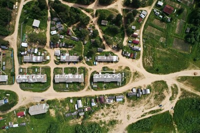
Daytime experiments with the system aboard a small airplane over several weeks in Yiwu City, Zhejiang Province, China, successfully revealed detailed features of various landforms and objects, confirming the functionality and reliability of the system in real-world scenarios. The long-term goal is to install the system on a spaceborne platform such as a small satellite. The researchers commented that the system could be deployed on drones or small satellites to monitor changes in forest landscapes, such as deforestation or other impacts on forest health, or to generate 3D terrain maps in areas hit by an earthquake.
The biggest takeaway from the published research is that the new system could make single-photon lidar practical for air and space applications such as environmental monitoring, 3D terrain mapping, and object identification.