
Contributed by Aude Camus, Bentley Systems
Developing a National Map of Singapore
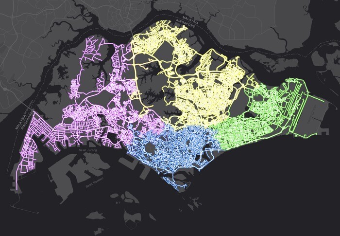
As it grows and develops, the island nation of Singapore wanted to ensure that it effectively uses its land and space resources. Therefore, the government agency Singapore Land Authority (SLA) initiated a national 3D mapping of Singapore via aerial and street mobile mapping with a “capture once, use by many” objective to create a smart, resilient, and sustainable nation. Over two phases, the project sought to map the entire nation with rapid reality data capturing technologies, creating an accurate, reliable, and consistent national 3D map that supports government agencies in their policy formulation, planning, operation, and risk management.
“Singapore is a garden city and 47% of land is vegetated,” said Hui Ying Teo, senior principal surveyor at SLA. “With the national 3D mapping, we were working with research institutes to take stock of our natural capital, as well as carbon stocks.”
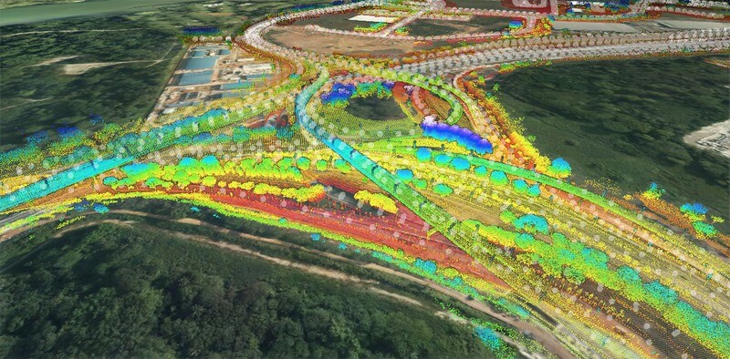
For aerial mapping, the team would need to conduct 3D mapping over the entire land mass within 40 days at the highest level of detail. Mobile mapping meant providing point density of 40 points per square meter and 360-degree panoramic images at 20-meter intervals. However, the team also needed to remove people or cars from all images and ensure that it captured the reality data hidden behind these objects.
Going Digital with Digital Twins
SLA knew that conventional methods would not be effective on this project. The mobile mapping data collected for all the island nation’s public streets amounted to about 25 terabytes, and sharing that reality data with government agencies would mean duplicating the data sets. This method would mean that agencies could potentially be using old or inaccurate data to make decisions, leading to longer decision-making workflows.
Additionally, the team needed to refine about 600 billion point clouds. They sought to integrate the aerial mapping data and street mobile mapping data—such as point clouds and 360-degree panoramic images—to ensure that there were no overlapping data points. SLA realized that the best method was to create a digital twin with reliable 3D data. Therefore, they needed a comprehensive, web-based application to manage the massive amount of reality data and develop a digital twin.
Improving Collaboration in a Data-centric Environment
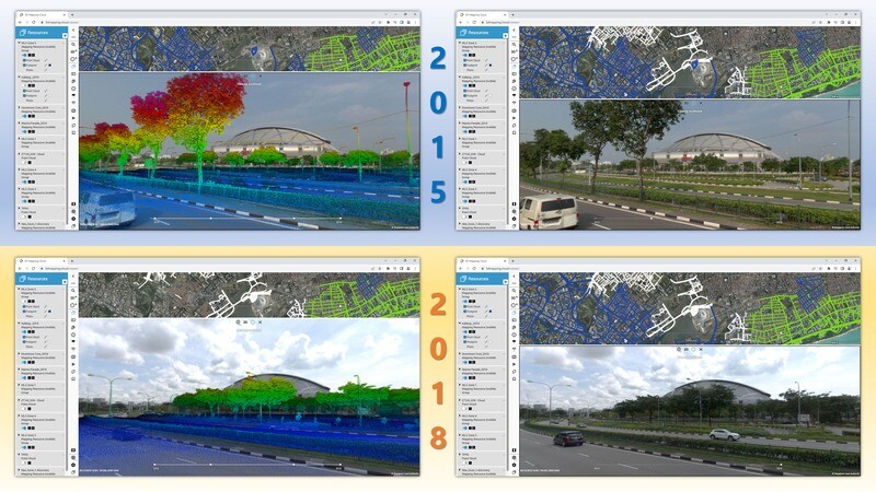
Already familiar with Bentley applications, SLA selected Orbit 3DM, one of the key technologies powering iTwin Capture along with ContextCapture, to create a web portal, allowing the team to manage and integrate the large volume of point clouds and images. They then generated a digital twin, called SG Digital Twin, to bridge reality data sharing with multiple users via cloud-based resources.
“Bentley’s Orbit 3DM solution enabled us to deliver a digital twin to our government agencies through just a web portal, without these agencies investing in IT infrastructure to host and store the datasets at their end,” said Teo. “Users with passwords can access the datasets from their web browser, streaming terabytes of datasets effortlessly in the ease of their office or from home.”
This capability was especially important during the COVID-19 pandemic, as it allowed users from different agencies to discuss a specific site without having to meet in person. Instead, they could annotate and collaborate within the virtual environment while knowing that everyone was looking at the same — and the latest — data. When other users required access to the data, the team could create a localized publication that allowed these individuals to view the site and provide their own feedback. Data owners could manage, assign, and control access to users based on their roles, ensuring that everyone had the right information and the right time to make the best decisions.
Saving Significant Time and Cost
SLA’s SG Digital Twin increases data availability by 50 percent, enables accurate information extraction, and delivers a sustainable, collaborative digital twin that can be used for multiple planning purposes. “With these data capture methods, the annual potential savings by the government is at least SGD 5 million with a refresh cycle of once every two years,” said Teo.
By using rapid national street mobile mapping, SLA is seeing significant savings when compared to traditional means of topographic or terrestrial surveys. With topographic surveys to map out public streets across the nation estimated at SDG 30 million, SLA and the Singapore government saved SDG 26 million. Additionally, rapid street mobile mapping saved about a year in mapping the nation, allowing planning to take place within a shorter period. In addition, the point cloud and imagery has provided more ground information than what conventional surveying can achieve.
“We are excited to see the plans that Bentley has in the pipeline to elevate the Orbit solution, [and] perhaps even talk about metaverse in the near future,” said Teo.


