
New RiSOLVE software combined with VZ-line of laser scanners is ‘future of terrestrial scanning techniques,’ says RIEGL
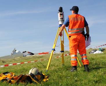
RIEGL Laser Measurement Systems GmbH on Tuesday launched its RiSOLVE software, which creates a 3D environment for accident investigators to virtually recreate the point of impact from any angle for collision analysis and visualization.
“When it comes to accident investigation and rapid deployment scene capture, time is of the essence,” the company said in a press release. “Fast data capture, fast turnaround time to clear a scene, and fast data processing is vital to reducing field time, increasing safety, and delivering precise results.”
Headquartered in Horn, Austria, RIEGL manufactures terrestrial (static), mobile (kinematic), airborne and industrial laser scanning hardware with proprietary software packages for data acquisition and processing for multiple fields of applications.
RIEGL called the combination of its VZ-line of terrestial laser scanners and the new software, which it calls the “fastest and most efficient solution to acquire, register, and colorize outdoor 3D scan data through its fully automatic registration and colorization,” represents “the future of terrestrial scanning techniques.”
RiSOLVE enables rapid turnaround of critical information, with additional tools for filtering, scene animation, and measurements, which can be revisited repeatedly.
RIEGL said it has been field testing RiSOLVE for the past six months, making sure it is effective in “nearly all real-world conditions.”
“With input from real users we have made steady improvements and are now confident that the algorithms behind the automation are ready for release,” said Ananda Fowler, RIEGL’s manager of terrestrial laser scanning software development.


