

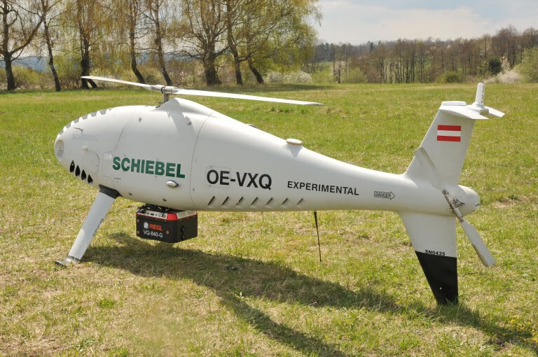
RIEGL recently cooperated with the Vienna-based Schiebel Group to integrate one of its topo and bathymetric lidar sensors into its flagship product, the Camcopter S-100 Unmanned Air System (UAS). This is a Vertical Takeoff and Landing (VTOL) system that operates day and night, under adverse weather conditions, with a range out to 200 km, both on land and at sea. The system is used for a range of applications, including oil, gas, security, and geophysical surveys. In a typical configuration, it carries a 75-pound (34 kg) payload for up to 10 hours.
The S-100 navigates automatically via pre-programmed GPS waypoints, or can be operated directly with a pilot control unit. Missions are planned and controlled via a simple point-and-click graphical user interface. High-definition payload imagery is transmitted to the control station in real-time. Using "fly-by-wire" technology controlled by redundant flight computers, the UAV can complete its mission automatically in the most complex of electromagnetic environments. Its carbon fiber and titanium fuselage provides capacity for a wide range of payload/endurance combinations.
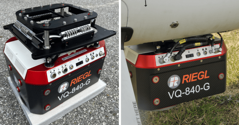
RIEGL's VQ-840-G topo and bathymetric lidar sensor
The topo and bathymetric lidar sensor that was integrated into this system is the RIEGL VQ-840-G, a fully integrated compact airborne laser scanner for combined bathymetric and topographic surveying, where the scanner carries out laser range measurements for high-resolution surveying of underwater topography with a narrow, visible green laser beam, emitted from a pulsed laser source. Subject to clarity, at this particular wavelength the laser beam penetrates water enabling measurement of submerged targets. The sensor weighs approximately 12 kg, or under 15 kg including an IMU/GNSS and camera or IR rangefinder.
Creating a tailored solution
Operating a high-end laser scanning system remotely on an uncrewed aerial vehicle requires a tailored solution that goes beyond what is currently available off the shelf. To maintain the broad operating range of the UAV, it is recommended to keep the weight of the sensor payload low. Additionally, the effective execution of the survey mission requires full remote control of the payload instruments and real-time feedback to the operator via a data link.
RIEGL’s laser scanner was designed for use in a variety of maritime and hydrographic environments. The lidar sensor payload system is controlled remotely via a data link, which is crucial for integration into the S-100 system. The scanner is controlled using the onboard software RiACQUIRE-Embedded via the available data link, while data acquisition and laser safety are also monitored. Once a survey is completed, the raw data seamlessly integrates into the RIEGL data processing workflow.
Surveying shallow waters
Combined with the Camcopter S-100 UAS, the RIEGL VQ-840-G enables an efficient and secure way to survey shallow waters, where monitoring from boats becomes a challenge. The applications of airborne lidar bathymetry (ALB) include mapping coastlines and river banks, monitoring natural habitats and water reservoirs, and hydraulic engineering applications such as canals, dams, and bridges. Data both below and above the water surface can be covered in a single data acquisition mission.


