
Of indoor GIS: ‘I would say the message is definitely starting to hit home’
PORTLAND – In late June, the Technology Association of Maine named Stuart Rich, CTO of PenBay Solutions, its CxO of the Year. In doing so, the group cited Rich’s contributions to the Northeast Arc Users Group as board member, the University of Maine’s Spatial Information Science and Engineering Department (recently inducted into their Francis Crowe Society), and BISDM and the Spatial Roundtable as a thought-leader.
The award is also, though, validation of his work at PenBay, which has long been an evangelist for moving GIS information inside the building, along with using 3D mapping inside.
“I would say that the message is definitely starting to hit home,” Rich said in an interview with SPAR 3D, “which doesn’t mean that there isn’t still a lot of evangelism to be done. We’re starting to create a significant amount of business somehow.”
Those most clearly seeing the value of using GIS indoors are “customers who have a reasonably large portfolio of facilities and have a long term ownership interest in those facilities,” he said: military bases (MacDill Air Force Base is a customer), municipalities (Philadelphia and Boston), government agencies (Veterans Health Administration), higher education (Kuwait University), large manufacturing operations. However, the contact points at those facilities are all over the map: facilities manager, site locators, security directors, construction project managers.
“You can’t say there’s one group that’s head and shoulders above the rest” in seeing the value of indoor GIS data and 3D mapping, he said. “Depending on the customer, depending on how we get introduced to the customer, it may be a wide range of those kinds of folks.”
For those in site-selection, the allure might be the integration of the potential physical plant with the larger business demographics in the area. In construction, the value might be in identifying and mitigating conflicts on site in terms of what occupies what space and when. In occupancy, the money saver is being able to identify facilities that are underutilized or identifying fragmentation in your departments.
“In most large organizations,” Rich said, “the cost of occupying a facility is the second item on the expense side, right behind salaries. So any increase in occupancy rate goes right to the bottom line.”
Essentially, the more you understand about your facility, the better decisions you can make.
So, why isn’t PenBay calling what they do BIM? “I’m a huge fan of BIM,” Rich said. “I think it’s an absolutely terrific tool, particularly for the design and construction part of the facility lifecycle. It allows you to be in constant communication with the construction professionals, identifying conflict and quickly delivering cost estimation. It’s a tremendous advance in the tool set available to that industry.
“That said,” he continued, “because of its nature, it’s particularly good at project design and construction kinds of problems; it’s not particularly good at large-scale facility operations and maintenance problems. It tends to be highly detailed. It tends to be not in any sort of real-world coordinate space. It tends to be file based.”
Finally, “BIM is a new-building technology; there is no BIM for existing buildings, and that’s 96 percent of our current inventory.”
But what of the burgeoning scan-to-BIM market?
“BIM for existing buildings is a great idea,” he allowed, “but the scan-to-BIM process unfortunately can only capture what you can see, most of the scan-to-BIM really requires a structural engineer to complete the BIM process. Scan-to-BIM might get you half the way there, and it’s definitely a huge step above the previous measuring tape and CAD approach.”
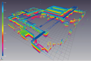
Along those lines, PenBay is using the Trimble TIMMS indoor-mapping solution to bring 3D visualization to some of its solutions. The city of Philadephia used TIMMS to collect lidar data and created a standards-compliant geodatabase useful to city agencies as an extension of their existing GIS (see the full case study here). Philly is working directly in a lidar point cloud of indoor spaces, and Penbay even delivered a 3D video data set for the entire captured area.
However, Rich cautioned, 3D isn’t for everybody. Often, 2D is enough for indoor GIS.
“You need to decide whether there’s enough value there to make it worth the significant step to 3D worth it,” Rich said. “For some business problems, it’s not worth it. For some, clearly there is enough value there. We help customers make those calculations. As much as anything it’s helping them figure out what the cost in terms of money and calendar days is in making that step from 2D to 3D.
In a construction application, or plant and process, where accurate clash detection can mean significant savings, the move to 3D can be well worth the investment. For a department store managing where inventory is displayed, 2D might be plenty.
“Everyone wants 3D. It’s intuitive and beautiful,” Rich said, “but the number of people who are willing to pay $2 a square foot [for textured, fly-through-quality visualization]is significantly less.”


