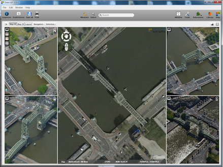
Orbit GT says oblique imagery adds ‘dramatic insight’ to contingency, urban planning
Orbit GeoSpatial Technologies rolled out a new addition to its Mapping 10.5 portfolio, Orbit Obliques, the company’s first full-support software for oblique imagery.
Belgium-based Orbit GT develops software for managing, feature extraction, publishing, embedding and sharing mobile, UAS and aerial mapping data in workflows.
“This long-awaiting release emphasizes our engagement in bridging the gap between airborne and mobile mapping,” said Peter Bonne, Orbit vice president.
Oblique imagery is aerial photography captured at an angle, typically 45 degrees with the ground. Obliques allow for more accurate measuring than straight-down photography (nadir), since viewers can not only see the top of objects but the sides as well. Basically, oblique imagery resembles how people view their landscape compared to nadir imagery.
Orbit said oblique imagery can “add dramatic insight” in emergency situations, contingency planning, urban planning, and 3D city modeling.
The new desktop software – based on a GIS and photogrammetry system – supports all camera types and image metadata as well as all projection and data acquisition systems.
Obliques also integrates orthoimagery (geometrically corrected to be used as a map) and other base maps. Support of DTMs (digital terrain models) allows accurate matching vector data overlays and 2D and 3D measurements in one image using the DTM or using triangulation by measuring in two images.
Obliques can be integrated with Orbit’s Mobile Mapping, UAS Mapping and Photogrammetry software, and is the first in a new line of oblique imagery software to be released, Orbit said.
Similar to Orbit’s Mobile Mapping software portfolio, oblique data will be made available in corporate client/server setup, online publishing and SDK embedding.
Imagery copyright Slagboom & Peeters, The Netherlands.


