There is a tremendous amount of value to be gleaned from aerial imagery, providing a bevy of information about large swaths of land around the world. This information can be a key for any number of industries, with government agencies, insurance companies, and social media organizations among the many who turn to companies providing this information. Being able to get a broad look at how things change after weather events, what the landscape looks like ahead of a construction project, and layouts of specific areas is a necessity for these industries.
Nearmap is one of the leaders in providing this aerial imagery, and earlier this month they announced a host of new features, largely centering around addressing problems arising from climate change. Don Weigel, Nearmap’s Senior Vice President of Product, took some time to speak with Geo Week News about the news additions to Nearmap’s product roadmap and what their customers can gain from the new offerings.
New Layers Added to Nearmap AI
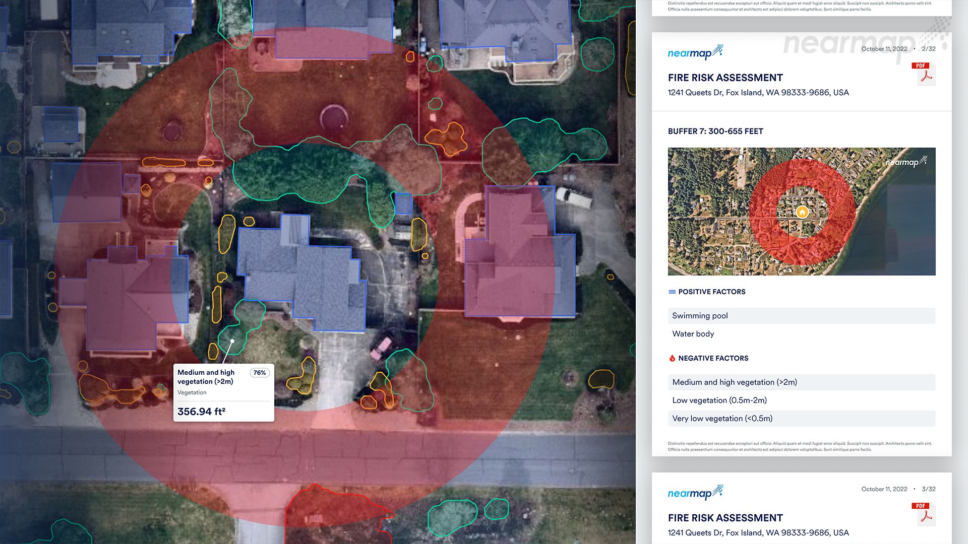
One of the big highlights from Nearmap’s announcement was the release of their fifth and latest generation of Nearmap AI. As part of enhancing the deep learning model, the company has added in a bevy of new information, increasing the number of layers included in its automated map from 49 layers to 78. As Weigel explained, there are so many additions that it’s hard to narrow it down to just a few as the most important. That said, there were a few he highlighted, including attributes related to roofs and objects on roofs, as well as surfaces and surface permeability.
These additions are certain to provide value to a number of different industries, with insurance and government being two specifically. Roofs are a hugely important part of anything relating to property, so having this kind of information is crucial for things like helping companies determine repair estimates for roof replacements. With climate change-related weather events becoming more common, having this information about roof damage is only going to become more important.
It’s not just the new layers that are adding value to Nearmaps customers either, as the customer has also a new near-infrared capability to power better artificial intelligence data, thereby improving the accuracy of the added surface layers. That in turn will help assess damage and wreckage, which again will only be more of a priority as time goes on. These improvements have already been put to use, too, with the company’s keynote announcing these additions at NAVIG8 noting that these capabilities have already been utilized, detecting damages resulting from Hurricane Ian in Florida.
The New HyperCamera3 System
Among the other big announcements from Nearmap for their newest additions to their product offerings is their new patented and proprietary aerial camera system, HyperCamera3. The camera will be capturing spring leaf-off content in North America early next year. As Weigel explains, there were some primary goals the company was looking to accomplish with their new product. The biggest was to provide better ground sampling distance (GSD) than their competition, leading to higher resolution and better ground sampling distance. In other words, as Weigel says, “this camera is capable of incredibly high resolution, and from a higher altitude.” That means some highly detailed information that previously could only be captured with a drone can be captured with HyperCamera3
He further explains that the camera collects data with a proprietary, sweeping design. With a set of mirrors, Nearmap is able to capture up to 14 angles for every location on the ground. This, in turn, leads to more angles to create a smoother reconstruction for a textured mesh and a better overall 3D product. Given the growing importance of 3D modeling as that technology becomes more accessible, that higher accuracy coming from this aerial imagery is a game-changer.
And it’s not just that they’re introducing this new camera, but they’re building enough of them to be able to increase the size of their fleet. Weigel explains that they’ll now be able to collect a higher percentage of parcels, continuing to grow the company’s footprint. This should give customers an even greater amount of information around their area than they already had. Nearmap is a subscription service, and subscribers get multiple data collections every year along with all past information for a given area. That varies depending on the area, but generally they collect data at least twice a year to capture leaf-offseason as well as leaf-on, with some areas being captured more than that.
Nearmap’s Other Additions
The new layers being added to Nearmap’s automated map and the HyperCamera3 system are only a couple of the key improvements made by the company. Weigel also explained some of the other key additions made. Perhaps at the top of that list is GeoData Link. Available with a Nearmap subscription, GeoData Link allows users to bring their own spatial data into MapBrowser, the company’s software for aerial views, while also supporting integration with a ArcGIS Map.
He also highlighted Nearmap’s new collaboration tools. The ability for different stakeholders to collaborate seamlessly has always been importance, but the pandemic has certainly made organizations look more for remote collaboration tools. Nearmap is now offering these tools in MapBrowser. Whereas previously these projects acted as a “single user” where each stakeholder has their own project. With the new collaboration capabilities, different users can bring in their own files into a single project and pull everyone’s data together. The company’s next release will add real-time editing, providing a solution which Weigel compares to that of a Google Doc.
These are just a few of the new solutions being offered by Nearmap to provide highly-accurate and valuable insights from aerial capture data.