
The National Geodetic Survey (NGS), part of the National Oceanic and Atmospheric Administration (NOAA), is in the midst of a massive project to modernize the National Spatial Reference System, work that in some ways dates back to the implementation of their last reference system that was created in the late 1980s. The work really started in earnest within the last decade or two, and the updated NSRS, GEOID2022, is expected to be completed within the next couple of years, and will be based on a geoid model of the Earth.
This is work we covered more in-depth earlier this year, speaking with NGS’s Galen Scott and Oregon State’s Dr. Chris Parrish about the modernization work, why it started, and its importance. As we noted at the bottom of the linked article, we are continuing a series in which we are talking about this work, and more specifically the contributions being made by the Geospatial Center for the Arctic and Pacific (GCAP), which is led by Dr. Parrish and received a grant from NGS to “address key issues facing the geodetic community.”
Today, we’re looking at a more specific piece of this modernization work, focusing on bathymetric surveying. Geo Week News spoke to Charles Seaton of the Columbia River Inter-Tribal Fish Commission about a project he is working on as part of GCAP and how the modernization initiative fits into both this project specifically and bathymetric and hydrologic work more broadly.
It’s worth starting with bathymetric work’s place in the surveying world, as it’s generally not what is immediately imagined when people talk about surveying. While terrestrial work makes up the majority of surveying, bathymetric work is carving out an increasing portion of the industry’s attention for a couple of key reasons. One is that it’s simply become easier. Solutions that can do coastline and inland waterway surveying are significantly more accessible than ever before, as well as being more powerful. More importantly, our effects on the environment have become more clear (or at least more accepted) over the last few decades, and monitoring of these coastlines is one of the crucial pieces of environmental work.
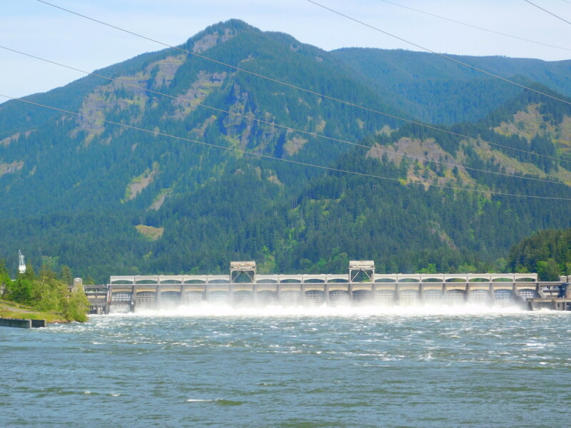
Because of this growing importance, and growth within the field itself, it makes sense that hydrological work is being considered in the broader modernization project from NGS. Seaton, for his part, spoke with Geo Week News about a specific project he is working on, along with the Yakama Nation Fisheries Program and the US Army Corps of Engineers, around the Columbia River and Bonneville Dam. He’s been doing work in projects around this area for “basically [his] entire professional career.”
A lot of the conversation focused more broadly on bathymetry’s place in the modernization of the NSRS, and he said that from his perspective as a modeler the most important reason why hydrology is so crucial to this work is that the datums determine the bathymetry. He went on to explain that it’s less important for local work where one can use datums that are location-specific – such as from a local tide gauge. It becomes a bigger problem once larger areas come to play, however.
“Because your surveys aren’t necessarily going to be done relative to your local datum, they’ll initially be done relative to a global tidal datum. By the time you get them, they’re likely to have been converted to some other datum, so being able to combine bathymetry across datums and have more accurate datums, it’s really important for having accurate bathymetry.”
He went on to explain that the differences between datums can be “quite substantial,” and it’s important to be careful that one is using the correct datums and converting between them correctly. Seaton said that NGS’s updates will improve this work and make it significantly easier.
“Having a good geoid model and a national spatial reference system, and having real-time systems for correcting to datum, allows you to collect bathymetry much more effectively. Rather than having to establish a tide station and making sure that you’re not collecting your bathymetry too far from your tide stations, we’re able to just hook into the real-time network and determine the vertical position of our sensor instantaneously as we’re collecting data, so that we’re generating bathymetry data that is referenced to the geoid.”
Interestingly, Seaton noted that the modeling community has actually not even been using the NAD83 and NAVD88 datums that are being replaced in this current modernization effort, instead relying on NGVD29. Those numbers represent the years they were created, meaning this system is nearly a century old at this point. Still, while the newer datums were certainly an upgrade for terrestrial surveying, NGVD29 has proven more valuable for hydrological work.
“Despite all of its serious problems as a surveying datum, its one good feature is that it is directly tied to mean sea level all across the US and Canadian costs,” Seaton said. “That means that if you have bathymetry and it’s relative to NGVD29, or your convert it to being relative to NGVD29, then it approximates the datum zero being mean sea level, which is very valuable for doing ocean modeling because your vertical zero is mean sea level.”
Now, they’re shifting towards using the geoid model as the datum, which Seaton said does “something similar to NGVD29 in terms of having a fixed gravitational surface that approximates mean sea level.”
Seaton is working with Dr. Parrish and others on applying bathymetric work around the Columbia River, and he told Geo Week News that they will be linking bathymetric surveys to a national datum, something he described as “fairly new.” He and the rest of the team will develop procedures for that work with less experienced crews.
This work is still in its relatively early stages – Seaton pegs a roughly five-year timeline for this particular project to develop a hydrodynamic model for the Bonneville Pool – but he sees real advantages for bathymetric work in general with the new geoid model and the modernized NSRS. Since this work is generally less stable than terrestrial surveying – the landscape changes far less frequently than coastal areas – the ability of the new geoid model to help integrate historical data in a more reliable fashion is valuable.
“Being able to apply the modernized spatial reference system to allow us to collect data where we need it, I think is a really important change.”


