
.jpg)
UltraCam division of tech giant says combo of new Osprey camera, UltraMap workflow pushing airborne laser scanning out of certain applications
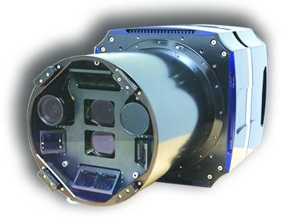
Microsoft’s photogrammetry division debuted the UltraCam Osprey, its new digital aerial system combining a high performing photogrammetric nadir camera with oblique image capture capabilities, and challenging airborne laser scanning in several applications including 3D urban mapping and mining.
Headquartered in Graz, Austria, with a U.S. support team in Boulder, Colo., the UltraCam division rolled out the new camera last week at the annual American Society for Photogrammetry and Remote Sensing (ASPRS) conference in Baltimore.
‘Significant change’ in photogrammetry
The company said there has been a “significant change” in photogrammetry with the advent of digital aerial cameras, such as the UltraCam, and end-to-end photogrammetric workflow software, such as UltraMap 3.0 introduced in November, that allows users to generate 3D data products from one flight.
Microsoft said this process was called multi-ray photogrammetry, a specific flight pattern with up to 90 percent forward overlap and increased sidelap of up to 60 percent.
The third generation UltraCam builds on UltraCam Eagle technology, delivers subpixel accuracy, high dynamic range, and integrates all system components in the sensor head including the optional UltraNav direct georeferencing and flight management system.
The UltraCam Osprey houses two cameras in one photogrammetric grade housing, using technology with nadir and oblique wings. Due to the overlap with the nadir part of the camera, the wing image orientation can be further improved by automated tie point matching, Microsoft said.
The strip width of the UltraCam is around three times bigger compared to a lidar system and the point density is around 30 times higher, the company said.
“This makes additional airborne lidar scanning obsolete for many applications,” the UltraCam team wrote in a paper last year detailing the UltraMap software titled “The Power of Multi-Ray Photogrammetry.”
The company said applications for urban mapping, mining, and national mapping “are better served by photogrammetry in the future.”
.jpg "04.05.13-msoss") Microsoft shakes up industry with release of UltraMap v3.0
Microsoft shakes up industry with release of UltraMap v3.0
The Microsoft division in November released UltraMap v3.0, the first integrated end-to-end photogrammetric workflow system, including automated 3D point cloud, digital surface model (DSM), digital terrain model (DTM) and ortho image processing, for UltraCam images.
“We expect a significant change in the industry with the release of UltraMap 3.0,” the company said when the software was released.
UltraMap processes the images using a dense matching algorithm and an automated ortho/true-ortho workflow that was exclusively used, previously, for the automated 3D city model production of Microsoft’s Virtual Earth project and its BING maps platform.
The algorithm generates very dense surface models by overlapping aerial images automatically, creating a highly redundant, versatile dataset with automatic project-based color balancing for homogeneous image block color correction.
UltraMap generates high resolution, highly accurate 3D point clouds with a point density of several hundred points per square meter – much denser than any airborne lidar scanning point cloud, the company said.
UltraMap v3.0 offers two new modules:
- UltraMap Dense Matching module
- UltraMap Ortho Pipeline module
The dataset can be used for most photogrammetric applications, such as cadastre (property inventory), infrastructure planning, and generating automated 3D data and DTM (digital terrain modeling) or DSM (digital surface modeling) ortho mosaicing images.
UltraMap delivers quality DSMs at high accuracies and without any manual interaction by generating seamlines at desired paths.
Remaining seamline editing for challenging regions are corrected using UltraMap’s DragonFly technology, a visualization engine for users to conduct quality control on large image blocks efficiently.
The UltraCam Osprey will be available for delivery to customers in the fall, the company said, adding that existing UltraCam customers can receive trade-in credit toward upgrading to an Osprey any time.
“The UltraCam Osprey is the beginning of a new chapter in the development of the UltraCam product line that combines multiple sensors and mature software to achieve richer datasets,” said Alexander Wiechert, Microsoft business director. “The versatility of the UltraCam Osprey should open up new opportunities for our customers.”
Microsoft got into the digital aerial camera business in 2006 when it acquired Vexcel Imaging, GmbH. The company’s portfolio of UltraCam sensor systems and digital aerial mapping systems includes the UltraCamLp, UltraCamXp, UltraCamXp Wide Angle, UltraCam Eagle and UltraCam Falcon digital photogrammetric sensors.


