

Towards the end of June, Earth intelligence and space infrastructure company Maxar Technologies announced an expansion in their partnership with GIS leader Esri. Under this expanded partnership, Maxar will make its Precision3D data available for viewing in Esri’s ArcGIS Online Living Atlas of the World. Per the announcement, users will be able to view Maxar’s Precision3D Digital Surface Model, Digital Terrain Model, Buildings and Vegetation vector data integrated into ArcGIS Online.
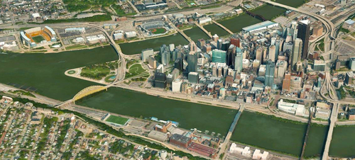
Precision3D serves as a base for 3D digital twins in a variety of sectors, utilizing satellite imagery from Maxar’s fleet to create models at 50 centimeter resolution and an absolute accuracy of three meters SE90 (Spherical Error 90 percent). To create these models, Maxar uses multi-view stereo techniques to combine multiple satellite images of an area from multiple angles, utilizing a patented algorithm to turn those images into an accurate 3D model. Precision3D offers the Digital Surface Models, Digital Terrain Models, and vectors mentioned above, as well as point clouds and true ortho from their satellite imagery.
On the other side, the ArcGIS Living Atlas is Esri’s library of geographic information, including maps, applications, and data layers, available to ArcGIS users to support their work. With the Living Atlas, professionals can skip the traditional – and lengthy – step of searching for and processing the raw data they need for their project, and instead add this information straight from the Living Atlas. The data is collected from work being done by GIS professionals around the world, and is an ever-growing library of geographic information which is constantly updated. Now, with this news, 3D data from Maxar’s Precision3D will be included within the Living Atlas collection.
Easy access to this highly accurate large-scale data is a valuable addition for many ArcGIS users, specifically those looking to create digital twins of bigger spaces like neighborhoods, cities, or even potentially entire nations. It’s never been a secret that 3D data is more valuable than 2D for a host of reasons, but the ability to actually create these larger 3D models has not always been there. Getting that large a dataset to a level accurate enough to create usable digital twins was long easier said than done, but with the current democratization of the earth observation space the challenge is becoming workable.
With Precision3D now a part of the Living Atlas, users will be enabled to “immerse themselves in a digital twin that unifies the physical and virtual worlds for better decision-making,” per the announcement of the news. We’ve seen Esri and the GIS world in general further embrace 3D ecosystems in recent years, allowing for new and enhanced use cases for these kinds of digital twins. Having highly accurate 3D data at this scale allows for more powerful capabilities for professions like city planners, who can run realistic simulations for urban environments, helping to plan things like road redesigns, new buildings, and disaster response plans.
These additional Maxar products are also available in ArcGIS Living Atlas:
Vivid Standard is a high-resolution, high-accuracy and visually-consistent global imagery basemaps built with Maxar satellite imagery.
Vivid Advanced upgrades Vivid Standard’s quality over select metropolitan areas with nearly cloud-free imagery basemaps.
NaturalVue 2.0 is an image mosaic that combines more than 60,000 Landsat 8 images to create a seamless, virtually cloud-free, 15-meter base map that reflects the Earth’s true colors.
National Urban Change Indicator (NUCI) is a commercial urban change detection product that highlights areas of new construction activity by isolating changes that persist over time, derived from more than 13,000 Landsat images.


