
Pacific Northwest residents now have at-a-glance views of hazard zones
PORTLAND – The Oregon Department of Geology and Mineral Industries (DOGAMI) has been using lidar to evaluate hazards for many years, since first coming upon the technology in 2004. They’ve used the technology to identify fault lines, evaluate lava paths should a volcano blow, identify landslides and predict future slides – you name the natural disaster and they’ve probably used lidar data to help mitigate its effects.
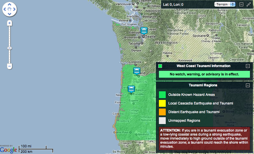
This week, DOGAMI, as part of the Northwest Association of Networked Ocean Observing Systems, released a web portal and free apps for both iPhone and Android that will allow the general public to both look at potential tsunami hazard zones and to plan evacuation routes should a tsunami strike. Of course, lidar data was vital to creating these releases.
“In a nutshell,” said Ian Madin, chief scientist at DOGAMI, “there are three elements to mapping tsunami inundation.” First is the shape of the sea floor, second is the propagation of the wave on the ocean, which is a math problem that’s now well understood. Finally, “there is the shape of the sea floor and landscape that the wave encounters when it gets to shallow water, when it changes from two feet high to 50 feet high.”
That’s where the lidar comes in handy. When DOGAMI first started looking at tsunami hazard mapping, “most of the topographic data was forty-foot topo,” Madin said. Some was 20, but some was 80. It was extremely low resolution and decades old.” So, they could do all the math, but the best-case scenario had them working with as much as 20 feet of potential error.
“Having good ground topography was crucial,” he said.
For this reason, and any number of other organizational goals, DOGAMI in 2007 went to the Oregon state legislature with a plan for creating the Oregon Lidar Consortium and beginning the daunting task of acquiring lidar data for as much of Oregon as they could afford. They asked for $5 million and got $1.5 million. But it was enough to start.
They contracted a fixed price for lidar, beginning at $1,000 a square mile and getting down to $500 a square mile if they bought it in enough bulk, with Watershed Sciences, a firm out of Corvallis, Oregon. Then they took that fixed price to lots of other government entities – cities, towns, tribes – and started pooling resources, showing them the utility of the data and sharing the cost of the collection so all of them could use it.
“The beauty is that we know exactly what it will cost and exactly what we’ll get,” Madin said. And because it’s all going through DOGAMI, all of the lidar being collected statewide is of the same quality and in the same formats. Plus, DOGAMI performs quality control on all the data being collected, so everyone has confidence in the quality of the data.
Since 2007, the consortium has collected more than 25 percent of the state, which is 95 percent of the state’s population, and all of it at eight points per meter resolution, with vertical accuracy at five cm. “It’s exceptionally accurate,” Madin said. “In some steep, heavily forested terrain, obviously we don’t get that, but especially in urban areas we can make one-foot contours with confidence.”
That leads to a much better ability to predict the impact of tsunamis (and lava, landslides, etc.). With the accuracy, too, comes more buy in from the public at large, Madin said. “We show them these maps and they get it,” he said. “They can actually see their house and the landslide and it’s obvious we’re not making it up. We know within a meter or two where things are and it’s really accurate data that they’re more likely to act upon.”
Hopefully a tsunami of the scale that hit Japan last year never slams into the Oregon coast. But, if it does, maybe residents will evacuate more quickly and in a more coordinated manner thanks to lidar and the work of DOGAMI and NANOOS.


