
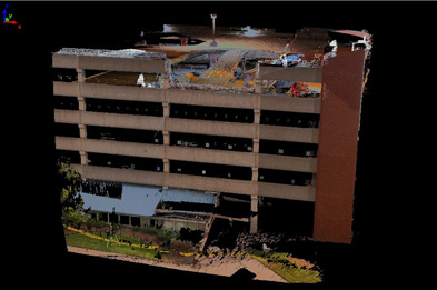
Failures of structures used by the public attract a lot of attention. Disasters like this are a mainstay of the evening news. Everyone wants answers, quickly. The morning after the collapse of a 30-foot section of the top floor of a six-story, 1000-car parking garage at CAMC General Hospital, Charleston, WV last July, survey crews from E.L. Robinson Engineering Co., Charleston, WV, were summoned to collect detailed geometric survey data of the garage to assess the damages and structural soundness of the structure and to assist with diagnosing the failure. Tom Rayburn, manager of surveying for E.L. Robinson Engineering, chose 3D laser scanning for capturing the most comprehensive collection of survey data points as quickly as possible, to satisfy the requirement not only for speed but for accuracy too. Here’s an account of how 3D laser scanning with robotic total station survey control was used to capture the garage geometry for the failure analysis.
Using the laser scanner, surveyors were able to collect in excess of 72 million data points in a three-day period that, using conventional surveying methods, would take several weeks to gather. Also, E.L. Robinson Engineering provided survey-grade data of the entire exterior of the garage within a week of the accident, compared with arguably a month using other surveying techniques. Not only was this data beneficial for answering the requests of the engineers’ original requirements, the as-built survey data can be used in the future for new projects relative to the parking garage structure.
No existing CAD model
Since the structure was built in 1980, nothing other than blue-line plans of the structure existed, according to E.L. Robinson Engineering, and no previous survey data was available for the analysis. No electronic CAD drawings were available, so a wireframe model was developed based on a set of blueprints; the mission of the survey team was to develop a CAD model based on the survey data and compare the results with the design plan.
The key elements that needed surveying included the vertical column location, spandrel beam locations, and mapping the actual site of the structural failure. The engineers needed enough survey data to determine if the ledger beam (spandrel beam) failure and resulting floor collapse caused the garage to move in any direction. They wanted to verify that the exterior columns were still vertically aligned. They also wanted to know whether excessive settlement had occurred for the spread footings of the columns, and whether rotation of the columns had occurred.
The E.L. Robinson Engineering surveyor’s approach to this project was to effectively combine highly accurate conventional surveying with the highly efficient 3D laser scanning. Surveyors established the control points for the garage using conventional survey methods. Surveyors then identified the same control points in the scan data, and aligned the multiple scans with the control and with one another. geovisit();
Acquisition work process
A Riegl LMS-Z360i scanner was used to capture 22 scans with 56 control points; a minimum of 5 control points was used for each scan position. High-resolution digital photographs were captured at each scan position using the scanner’s integrated camera. Survey control was achieved by measuring the position of the control targets using a Trimble 5600 Direct Reflex Robotic Total Station. The scanning took 3 days; the conventional survey of the control points required 2 days. E.L. Robinson Engineering’s team constructed a jig to locate column centers on the roof of the structure, and the position of these column centers was surveyed using the total station.
Post-processing
Riegl RiSCAN and InnovMetric’s Polyworks were used to register the point cloud data and then to mesh the points for subsequent export of a DXF file to AutoCAD and MicroStation. Excel spreadsheets of the coordinates of the column bases determined from the scan data and the column tops determined from the total station data were generated. Post-processing of the scan data and subsequent generation of the 3D wireframe model took approximately 4 person-days.
Survey results
The survey data indicated no significant column displacement, lean, or twist. Following repairs and modifications to the garage based in part on the survey data, the garage was subsequently reopened.
Lessons learned
E.L. Robinson Engineering Co. made the following observations:
- The only way to gather enough data to produce a sufficiently detailed 3D model in the time available was to use laser scanning.
- High-speed laser scanning combined with high-accuracy total station surveying can deliver engineering-grade data (6mm accuracy) suitable for failure mode investigation.
- Laser scanning allows safe and efficient data collection of areas difficult to reach with traditional surveying methods.
- Digital orthophotos together with conventional survey notes are valuable to office technicians for understanding building layout and features.


