
In February 2002 the Federal Highway Administrationdirected the Central Artery/Tunnel(CA/T) project in downtown Boston to investigate laser scanning techniques for determining critical clearances required for project close-out activities. As a result, even though the project was nearing completion and in some cases substantially complete, management decided to invest over $300,000 in laser scanning hardware and software. Why? According to Robert W. Priestley, resident engineer for the survey contracts on the CA/T project, the project’s survey department analyzed the cost of project close-out survey activities, and decided laser scanning would provide dramatically better return on investment than traditional methods. “Close-out survey work on the project would have cost about $6 million using traditional survey,” Priestley reports. “We estimated laser scanning would reduce that by roughly one-third. The $300,000 we invested was quickly recouped.”“In applications like tunnel as-built documentation and tunnel clearance inventories, we found big benefits,” Priestley explains. “Laser scanning lets us capture exact minimum clearances, which traditional methods don’t. Another major advantage is safety – laser scanning lets field
crews work off of the roadway.” Overall, the analysis convinced management that laser scanning would be the best way to capture data for a range of close-out survey activities including:
• Best-fit design for concrete overlays and bituminous surface finishes
• Detailed height clearance verification
• Street furniture inventories for detailed utility record-plan preparation
• Bridge and tunnel inventories
• Record-drawing preparation for recorded documents required by the City of Boston Public Improvement Commission
Project started with two scanners, just bought a third
In August 2002 the project purchased two Cyrax 2500 (now Leica HDS 2500) laser scanners together with Cyclone software, sent seven people for training, and began using laser scanning shortly thereafter.
The investment has been so successful, Priestley reports, that “the project recently purchased an HDS 3000 scanner, and took delivery two weeks ago. Based on initial field reports, it appears the unit is living up to our expectations. We don’t have final results yet because we need to get a new laptop to operate the scanner; the old one doesn’t have enough memory” to execute at top speed. The new Cyclone 5.0 software that comes with HDS 3000, he says, “needs 1GB of memory. But even using the old 256MB laptop, field times with the 3000 have been 25% shorter than with the 2500 – a project that would take 16 hours with the 2500 is taking us about 12 hours with the 3000. We expect the new laptop will bring that down to just 40% as long as the 2500 – a 16-hour project with the 2500 will take just 6 hours with the 3000.”
“We decided not to trade in the two 2500s, in order to have three units available,” Priestley adds. “At this stage of the CA/T project, each scanner is being used about 20 hours per week. At the height of activity, from November 2002 through February 2004, both 2500s were in use on single to double shifts, five days a week.”Portal clearances – Ramp D
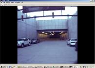
In one of several major close-out surveys, laser scanning was used to determine minimum distances of the opening at the project’s Ramp D portal to insure that minimum design clearances were maintained.
Data was captured in one primary scan in one hour, including setup time; Priestley reports that conventional surveying would have taken 8 hours. Scan data processing required two hours; processing of conventional survey data would have been quicker, but would not necessarily have found the minimum clearance. Complete deliverables, including 3D models of the roadway surface, portal opening and overhead beams, were provided within 24 hours.
The benefit of laser scanning, Priestley notes, is that capturing complete data makes it possible to determine where the absolute minimum clearance exists, whereas a conventional survey would only have obtained clearances where the shots were taken, and would not
necessarily have determined the minimum.
Tunnel roadway finish – Ramp D
In another survey, laser scanning was used to determine base slab as-built conditions and compare them to the design grades to insure adequate room for final pavement placement. Eight primary scans of a 1200-foot tunnel section were registered together to provide one continuous 3D view of the requested area. Cross-sections were modeled every 12.5 feet.
One view on this page shows a cross section at Station 25+00 of the concrete base slab compared with the design prior to the 3-inch overlay. This shows the overlay distances between the base slab and the design. At the far left, where the pavement meets the Jersey barrier, the clearance is 2.7 inches. The resulting report identified the delta differences between field (as-built) conditions and the plan (design) elevations at 12.5-foot intervals for 1200 feet of roadway.
Data was captured in 8 primary scans in 4 hours (1/2 day). In the 1200 linear feet surveyed, the data was used to produce 85 cross-sections at 12.5-foot intervals. Conventional survey would have taken 84 hours (8 days), and would not have obtained the data needed to cut sections at any desired interval. Processing took 8 hours (1 day); conventional processing would have taken 80 hours. Deliverables were provided within 48 hours (2 days); conventional survey deliverables would have taken 120 hours (15 days) to prepare.
Tunnel roadway finish – I-93 Northbound
In a similar survey to capture base slab as-built conditions on a section of I-93 Northbound, 5 scan-worlds were captured and registered. A typical cross-section of the mainline and ramp shows the widest section of the tunnel portion of the project, with four lanes in the main line and two additional lanes for the off ramp, for a total of about 80 degrees.
Before laser scanning was introduced on the CA/T project, this work had been carried out by conventional survey, using three crews working overtime at night. With conventional survey, it would have taken three weeks to complete the 3.5 lane-miles of this survey. With laser scanning, the 12 primary scans needed were captured in just 24 crew hours (3 days). Beyond the time savings, Priestley emphasizes the safety benefit – conventional survey would have placed the survey crew in more danger for longer periods of time.
Dewey Square – air intake structure
The purpose of this survey was to determine steel beam and column dimensions and plumbness. The time and safety advantages of laser scanning on this survey were much like those in the I-93 roadway survey. Twelve primary scans were captured in 24 crew hours (3 days), whereas conventional survey would have taken three weeks, and would have placed the crew in more danger for longer periods of time. With laser scanning, the need to access the open structure was limited to target placement and did not require crews to measure each beam individually.
Data processing took 16 hours (2 days), compared with 32 hours that conventional processing would have required. Scan data deliverables were provided within 40 hours (1 week), whereas conventional survey deliverable would have taken 160 hours (20 days).
Lessons learned: Cullinan
Wayne L. Mory, PLS, is chief surveyor with Cullinan Engineering Co., Inc. and general manager of The BSC/Cullinan Associates, a joint venture betweenBSC Groupand Cullinan Engineering that serves as the CA/T project’s survey sub-consultant. In embracing laser scanning, Mory reports, “We at Cullinan wanted to make sure we were part of what we felt would be a growing trend. It was a business decision to get involved. And the CA/T project was a prime opportunity to use it. From my
standpoint, the more that I could get resident engineers, contractors, construction people to understand the benefits of laser scanning, the bigger end-user market that I and others would have at the end of it.”
“Cullinan got into the business of laser scanning earlier than the CA/T project did,” Mory told us. “Cullinan felt it had to get on board early.” What were the challenges? “Learning to use the equipment is not the hardest thing – survey firms can usually scan and produce, but can’t always
scope and sell optimally. Even though we have this powerful new tool, sometimes it’s hard to think out of the box and say, ‘If we do this job using a scanner, how do we execute it?’ That learning curve is much longer than just learning how to use the hardware and software.”
“These are powerful instruments,” he continues, “and I need to understand where I can use them and where I can’t, or shouldn’t. I’ve used photogrammetry, total stations, digital levels, all for years, and I know when and where to apply them. This technology is a magnitude more powerful, and learning when and where to use it – and where not to – is important.”
Where should laser scanning be used? “Where there’s a high level of detail required. Laser scanning isn’t always needed. Sometimes we choose to use conventional survey, where we can tie new data into old, and just use CAD tools to document our work. The choice is driven by accuracy and level-of-detail requirements, and by job size.”
For successful laser scanning projects, “definition of scope is critical. It’s also key to educate the engineers in what the technology is capable of providing, and get them to ask only for what they need.” Mory explains, “In negotiating the scope with your client, only negotiate what they need.
Yes, you have the point cloud and can go back for more data, but that doesn’t happen very often – in the Artery project we haven’t yet been asked to go back into a point cloud except in select cases where we did base slab scans and the signs were already in place so we were able to extract clearances, probably a third of the locations we need, so that’s a savings but not huge. So it’s critical in processing the scan data to provide to the client only what they ask for. Our experience is that the technicians want to learn more, model more, and manipulate the data, but we as managers need to monitor it closely so after the learning curve we don’t do it unless the client wants it and will pay for it.”
Mory describes an added benefit of laser scanning for the CA/T project. “After the FHWA directive to investigate laser scanning for capturing clearances, I proposed that at the same time we update the project’s base mapping by producing updated topographic scans.” Accurate base maps were needed to prepare drawings of record required by the City of Boston Public Improvement Commission, “so our proposal addressed how laser scanning can help with two kinds of work: capturing the critical clearances, and updating the base mapping.”
Lessons learned: DGT
Michael Clifford is principal-in-charge of the Survey Engineering Group of DGT(Digital Geographic Technologies, Inc.), another contractor providing survey and laser scanning services to the CA/T project. His view of lessons learned? “I think it’s a shame this wasn’t available early on in the project, because the Big Dig is a geometrically complex project that strongly lends itself to use of this technology.” Clifford explains, “Laser scanning to verify and document what’s actually been built is especially valuable in a project like this, where there are multiple contractors and many overlaps in their respective work areas. Often one construction team will build a section of the project, then several years later another team will connect to it or build out from it. For example, it would have been valuable to use laser scanning to capture the top side of the tunnel roof before it was backfilled so that, if it later needed to be excavated for new construction, there would be an accurate record of what’s there.”
Further, Clifford advises, “surveyors gathering data with scan technology, and project engineers making decisions based on the data, need to have an understanding of the tolerances in scan measurements. In a construction project, decisions to accept a contractor’s work have to be made in real time, and it will not be unusual for scan data to be compared with conventional survey measurements.”
Another lesson learned was “the importance of coordinating the laser-scan data,” Clifford reports. “That means coordinating multiple scans produced by different survey offices, and also coordinating scan data with the overall survey control for the project. The value of proper coordination was reinforced. The Artery is a big project and it’s critical to have a good survey network in place, which the Artery has. But in the course of construction, control points can get changed, and large projects require constant attention to maintain agreement on survey control, particularly in light of the interfaces among different construction subcontractors, each with their own survey team, and with the project’s own survey office. In any project of this scale there’s an ongoing tug-of-way over survey control, but that is the basis for registering scans, so it’s essential that it be managed effectively.”
A further lesson, according to Clifford, is that “in projects similar to the Big Dig, where transportation infrastructure is threaded into an urban environment, laser scanning is an ideal method to produce base mapping. Three-D visualization can then be used not only for schematic renderings and fly-throughs, but also for final design.”
Project background: key participants
The owner of the Central Artery/Tunnel project is the Massachusetts Turnpike Authority, which is in partnership with the FHWA in funding the project. Bechtel/Parsons Brinckerhoff (B/PB), a joint venture of BechtelCorporationand Parsons Brinckerhoff Quade & Douglas, Inc., is the management consultant charged with overseeing all aspects of the preliminary and final design as well as all construction management. Robert W. Priestley is B/PB resident engineer for the survey contracts, with Parsons Brinckerhoff and assigned to the CA/T project since 1990 as the survey coordinator responsible for all survey activities on the project.
The project’s survey sub-consultant, charged with performing all professional survey consulting for the project, is The BSC/Cullinan Associates, a joint venture of the BSCGroupand CullinanEngineeringCo., Inc. The venture is led by Wayne L. Mory, PLS, general manager of BSC/Cullinan and chief surveyor with Cullinan Engineering. BSC/Cullinan has had multimillion-dollar-per-year contracts to provide B/PB with surveying and mapping services for the project since its inception in 1985, throughout the design and now the construction phase of the project. Two survey contractors, Cullinan Engineering and DGT(Digital Geographic Technologies, Inc.), operate the survey equipment and perform all construction quality control under the oversight of B/PB.


