
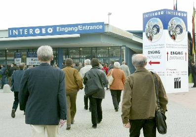
No comparable event in the U.S. quite prepares you for the scale of INTERGEO, Germany’s annual mega-fair for geodesy, geo-information and land management. When I walked into the Messe Stuttgart exhibition center last week, I found five halls packed with instruments, software and service providers for surveying, geodetics, GIS, aerial photography, remote sensing, photogrammetry, cartography – and of course 3D laser scanning. In all, 470 exhibitors from 23 countries filled more than 9800 square meters of floor space. Show management reported 16,500 attendees.
While laser scanning was far from the biggest component of the show, every laser scanning exhibit I visited had heavy attendance. Vendors reported that attendees were notably better informed about laser scanning than in past years. In the conversations I heard, no one asked “What is it?” or “What can it do?” Visitors were evaluating laser scanning for projects, or planning first or second purchases.
Some laser scanning highlights from INTERGEO 2004:
A new control unit from Callidus lets you operate CP 3200 – a EU75,000 scanner sold primarily for building and tunnel applications –from a commodity notebook computer instead of a dedicated Callidus-supplied PC. Visitors also saw CT 900 (list EU160,000) and CT 180 (list EU80,000), laser triangulation scanners for precision metrology of manufactured parts. The CT scanners were originally developed by
Intecu, which Callidus subsequently acquired.
InnovMetric didn’t appear to suffer from not having its own booth. Placing its software in several partners’ exhibits, sales director Marc Boulanger reminded people how popular PolyWorks is with users of many different scanners.
“Low-risk laser scanning” is how iQvolution describes its new pricing plan. CEO Bernd Becker explained his aim is to lower the risk of getting into laser scanning by lowering customers’ up-front investment. Bought outright, an iQsun 880 scanner lists for EU115,000 (EU125,000 with iQscene software). But under the new program, you pay just EU59,000 for the scanner, iQrecord software, and the right to make 50 scans. After that, you buy a key that lets you make additional scans – like a pre-paid phone card. Keys are sold in 100-packs. As you buy more, the price goes down. After your 5000th scan, keep scanning for free – in effect the machine is paid off. Other news from iQvolution included a color camera option, and software advances for color-image processing, meshing and one-click registration.
I had a fascinating dinner with executives from Jena Instrument Ltd., a land surveying company in Moscow that distributes iQvolution and Optech scanners in Russia. General director Grunin Alexander
estimates a total of six or seven laser scanners have been sold in Russia to date – including, he says, units from iQvolution, Leica HDS, Riegl and Trimble/MENSI. But laser scanning is having a tough time
getting going in Russia, according to Jena, because the government mandates that any new technology or technique must be accepted and certified as the official work process before it can legally be used.
(Sound familiar?) Nevertheless, Jena reports laser scanning is finding some acceptance in metals industries such as brass and nickel – large, vertically integrated businesses where one owner controls the mines, mills and factories. Some of these have reportedly gotten laser scanning certified for use in cavity mines; it’s also said to be turning up in some factories, authorized or not.
kubit demonstrated version 2.0 of PointCloud, its EU900 software package for visualizing and analyzing point clouds in AutoCAD and AutoCAD LT. President Matthias Koksch reports 130 units have been sold since the product debuted at last year’s INTERGEO, to a mix of cultural preservation, civil, industrial and other customers. kubit also showed TachyCAD for integrating total station data with AutoCAD and LT,
DistToPlan for integrating handheld laser distance measurements with AutoCAD and LT, and PhoToPlan, a digital image rectification tool that works with AutoCAD and LT.
Leica Geosystems HDS president Erwin Frei reported the company shipped 140 HDS scanner revenue units (e.g., not counting educational or demo units) in the six months ended September 30, 2004 – up from
43 units in the same period a year ago. The surge was driven by release of HDS 3000, which made up almost all units shipped, according to Frei. Going forward, Frei told us he expects HDS 4500 sales to grow now that Cyclone 5.1 (Leica’s software for controlling HDS 4500 and processing data from it) is available. Cyclone and CloudWorx software sales have yet to pick up as strongly as hardware, according to Frei, but he expects this will change as the new scanners start generating volumes of data that customers need to process.
ILRIS-36D, Optech’s new 360- by 360-degree laser scanner, attracted a lot of interest. Brent Gelhar, director of the Laser Imaging Division, thought that – judging by their expressions at his press conference –
some competitors may have been caught off-guard by Optech’s speedy introduction of the new model.
Riegl showcased software that automates digital image processing in conjunction with point clouds to generate orthophotos – a natural for users already finding high value in the digital camera option on its
scanners, Riegl USA president Ted Knaak told us. Phidias is a MicroStation-based orthorectification tool from PHOCAD GmbH; ScanDig3D is a tool for processing 3D orthophotographs in AutoCAD, from Stejskal KEG. Both are distributed by Riegl. Also new was wireless LAN capability for operating the scanner without cabling to the laptop. Meanwhile, towering over Riegl’s booth was MSP-420, for Mobile Scanning Platform – a wheeled truss assembly that elevates an LMS-Zxx scanner up to 3 meters in the air (currently available only in Europe).
“It’s sales time” – that’s how Trimble’s Omar-Pierre Soubra summed up the mood of attendees in his company’s exhibit. Trimble was demonstrating its GS Series laser scanners and MENSI point-cloud
processing software, together with its total station and related survey offerings. Soubra, Trimble’s portfolio manager for laser scanning application segments and markets, observed that INTERGEO attendees
are “still very survey-focused” – not a bad thing at all for his company.
Work with 13 billion (yes, billion) points at once – that’s whatZ+F’s new LFM Server lets you do, according to the company. The software makes it possible to view and manipulate up to 250 scans at a time, either
standalone or in the MicroStation environment. Z+F also showed off its new Profiler 6000-300 – the fastest 2D laser profiler in the world, it claims, able to capture 300 profiles/second operating on platforms (e.g.,
trains) moving at up to 120km/h. Price for this high-end device can range from EU300,000 up to EU3,000,000 depending on how the customer wants it configured.


