A surveyor’s office is often at the core of any local government, whether it’s city, state, or county, and is a crucial part of how work is done throughout a given area. In California, for example, it’s codified that every county is required to have a county surveyor, whose office has certain responsibilities to define borders and approve maps for professionals across the area. Traditionally, as you can imagine, this work involved a lot of paper and manual work, but recent years have brought on a digital transformation. This process was not as easy as flipping a switch, as the County of Santa Barbara’s County Surveyor Aleks Jervremovic explained in a conversation with Geo Week News, but the results speak for themselves.
“We don’t use much paper anymore,” he said. “We used to buy so much paper. Now, in a year we probably buy as much paper as we did for a month, or even a week, like 15 years ago.”
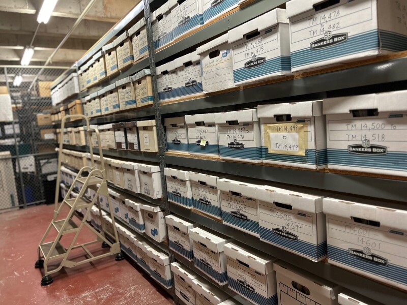
The amount of paper that was used in these traditional processes was unavoidable, but led to legitimate issues with the office. However, it was largely unavoidable. Prior to moving many of these systems online, the process relied on many paper maps, both being provided by the county surveyor’s office and being brought in by private surveyors.
“In the past, professionals like land surveyors, engineers, and land use professionals would come into the office to do their research,” Jervremovic explained. “They would line up at the counter, come in, do their research, and then get copies of the maps. We had the blueprint machine, and we would go make a copy of the map and sell them for $5.”
This process worked for many years, but it not only was inefficient compared to today’s digital processes, but also became increasingly burdensome in terms of physical space. The result of this work was a lot of documents and papers, stacks of folders, and a lack of what is expensive space.
“What are you going to do with all of the filed that you printed? You just put it into project files,” Jervremovic said. “So, they became very thick files. Suddenly, we were running out of space in our basement, and Santa Barbara is a very expensive place.”
As this space started to look like a really big potential problem for the county office, it was clear that some level of digitization was necessary. Of course, nothing like that can happen all at once, but it started as GIS became a more common digital offering around the world. Calling it the “main improvement,” Jervremovic noted that GIS combined with high-quality scanners started the county office on their path toward digital offerings. Now, instead of having to come in during office hours to review and receive maps, local professionals were able to access a web-based GIS.
“That was a very, very big achievement, because it made customer service easier for us, and also the customers were able to be more flexible,” he explained. “They did not need to come to the counter between 8:00 and 5:00. They could commit to their own customers at that time. Typically, our customers here are small businesses, and they could now do this research at 5:000 or 6:00 in the morning before they go to the site, and just download the maps from our GIS.”
That was just the start of the process for the county office, though, and Jervremovic was cognizant of not putting together half of a digital solution. There was certainly a lot of hesitation from the community, both staff and local professionals, with some staff even intimating that they would retire if everything went fully digital. Like so many other sectors, though, the COVID pandemic changed a lot of views when digital processes became the only option.
“Staff used to say, I’ll retire if we go digital,” Jervremovic told Geo Week News. “Then COVID hit, and suddenly they were the ones driving the change.”
The biggest challenge in this process was one of the more recent, as they tried to tie up the loose ends. After these maps became available online, there was something of a “half-digital” approach in which practitioners would email in the maps they needed to have verified and approved, and would say they would mail in the checks for payment.
“We didn’t want a partial solution. I’ll email you the package, and then I’ll mail you the check, or, I’ll email you part of the package, and then somebody will bring in the rest later,” Jervremovic said. “That didn’t feel like a proper way to spend public money. We wanted a solution that somebody could log in, upload all of the documents, and then pay the fee through the system.”
Now, they just had to build that system, and this is where they turned to Visus, a firm that specializes in helping organizations on their digital transformation. The firm, which is based in Santa Barbara, was already being used by other offices in the county government, so it made sense for Jervremovic to explore their assistance in this project. The partnership has worked out, with the office being heavily involved in creating the right process. “You’re not just buying the software, you’re mapping out every step of the process.”
This is a process that is always ongoing in a lot of ways, and the Santa Barbara County Surveyor’s office will continue to work through. Jervremovic says they are over 90 percent digital today, and that customers who were initially hesitant are fully onboard now. Reflecting on what he’s learned, though, Jervremovic mentioned keeping the industry in mind when making changes.
“One of our oldest customers told us, Next time, bring someone from the industry on board to help design it. And I think that’s great advice.”