

Back in February of this year, IBM and NASA announced that they would be collaborating on a new project aiming to create AI foundation models to “analyze petabytes of text and remote-sensing data to make it easier to build AI applications tailored to specific questions and tasks.” Given both the ever-improving technology around Earth observation data collection – of which NASA is both a driver and beneficiary – and the rapidly improving artificial intelligence models in all industries and IBM’s internal expertise in this area, this was a perfect time for this kind of partnership. And sure enough, they’re already seeing results. Last month, the pair unveiled the first foundation model produced from the collaboration, the watsonx.ai model.
The goal of this new geospatial foundation model is to track changes to our landscape changes like floods and wildfires by converting satellite data into high-resolution maps, with the hope of “revealing our planet’s past and hinting at its future.” The model is expected to be available for preview to IBM clients through the IBM Environmental Intelligence Suite at some point in the back half of this year. In their announcement of the news, IBM names a few potential use cases for the model, including to estimate climate-related risks to crops, buildings, and other infrastructure, valuing and monitoring forests for carbon-offset programs, and developing predictive models to help enterprises create strategies to mitigate and adapt to climate change.
A foundation model is a type of large machine learning model which is trained on a large amount of data and can later be adapted to a number of different types of tasks after development. Traditionally, models would have to be extensively re-trained for specific tasks in order to be effective, but the development of these foundation models have been one of the drivers to the current AI boom being experienced in all corners of the tech world, and really the business world overall.
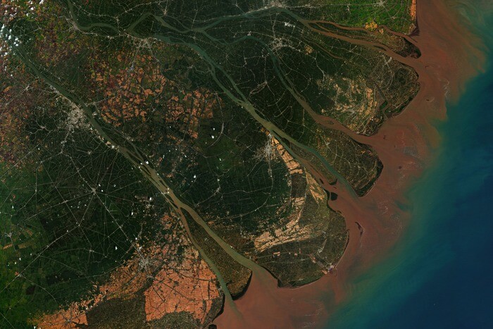
This is, according to IBM, the first foundation model designed for analyzing geospatial data. To summarize their process for creating the model – and a more detailed rundown is included in their announcement of the unveiling – the IBM Research team pre-trained NASA’s Harmonized Landsat Sentinel-2 data, a combined measurement which enables observations of land around the globe every two or three days at 30-meter spatial resolution. From there, they trained the model with hand-labeled examples of floods, fires, and other similar events which affected the landscape, creating a model with which users can simply choose a region, task, and date range to find the visualized information.
These kinds of models will only become more valuable in the coming years as climate change continues to have more pronounced effects on our planet. These models can not only give quick analysis of how things have shifted as a result of things like floods and fires, but also use past data to run simulations and have better guesses towards future outcomes, which will be crucial for business purposes in industries like agriculture, as well as for public health and safety efforts.
IBM indicates that the early results look promising for their model, saying, “In tests, researchers saw a 15% improvement in accuracy compared to state-of-the-art deep learning models for mapping floods and burn scars from fires, using half as much labeled data.” Presumably, this model and others borne from the methodology and collaboration with NASA will only become better over time, too. Right now, IBM is estimating that this model could speed up geospatial analysis by as much as four times.
Back in February when this collaboration was first announced, Rahul Ramachandran, a senior research scientist at NASA’s Marshall Space Flight Center, said, “It won’t just be NASA that benefits, other agencies and organizations will too. We hope that these models will make information and knowledge more accessible to everyone and encourage people to build applications that make it easier to use our datasets to make discoveries and decisions based on the latest science.”


