
Topcon: ‘There’s always been a desire for a high level of accuracy in GIS, but it’s always been difficult to get’
SAN DIEGO – Looking back on the ESRI user conference that happened here last month, it wasn’t surprising to see Topcon Positioning, which has long been associated with the GIS business because of its hand-held mapping tools. But more than one attendee was somewhat curious about Topcon’s 3D laser scanning vehicle parked outside.
Why bring a 3D mobile scanner to a conference that’s GIS focused? “We are helping to facilitate a paradigm shift in the way that data is collected,” said Barbara McInerney, GIS product marketing manager at Topcon. “As opposed to the traditional method of defining the features and then collecting them, we want to change that to collecting everything and then bring that data back to the office. Now you can collect the data once and then use that for projects to be determined at a later point.”
It’s long been understood that a user’s GIS is only as good as the data being put into it. Populating that GIS is just as important as selecting the right software, yet the task has long been laborious and fraught with some amount of difficulty.
Further, said McInerney, ‘There’s always been a desire for a high level of accuracy in GIS, but it’s always been difficult to get.” That’s where Topcon and others believe mobile scanning can provide a solution.
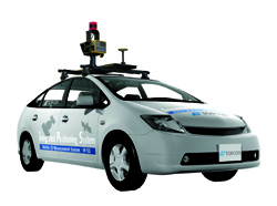
Topcon had on display its new HD system, which has a high-density scanner capable of collecting 1.3 million points per second, out to a range of 100 meters. The result, said McInerney is a point cloud with more recognizable features and an ability to capture smaller things, like overhead power lines or individual rail ties.
Utilities are becoming very interested in mobile mapping, said Dave Henderson, director of sales for Geospatial Solutions at Topcon. While NERC compliance is generally something solved with airborne lidar, many utilities are now using mobile scanning for asset management and to document third-party attachments to distribution poles.
“That’s where the revenue is,” said Henderson by way of explanation. “If they’re attached to your pole and you’re not getting revenue, you’re missing out.” Further, he said, “the larger utilities are starting to realize that you can’t fly over a subdivision, so they need alternative methods to collect data.”
Asset management is attractive to DOTs on an increasing basis as well, he said. Right now, states and municipalities are more likely to contract out the scanning services, Henderson said, “but I just had a city come up to me at ESRI, and they said the services are going to cost $400,000, but we can buy a system for that.” If a county or municipality has the revenue, you might see them now buying their own system for long-time use, Henderson predicted, or you might see a group of municipal governments pooling resources to buy a vehicle that they can share.
But are GIS professionals really ready to handle point clouds and the huge amount of data that is collected by mobile scanning systems?
“There’s a little bit of guidance that we need to give to people in how to manage it all,” McInerney said. “We’re finding software partners that we can partner with to offer a complete and total solution.” For instance, Virtual Geomatics, which offers a lidar management solution specialized for railroads and corridor mapping, and Orbit GT, which offers 360-degree panoramic image viewing and asset management solutions, were both in the ESRI booth with Topcon here in San Diego.
Both Henderson and McInerney agreed that municipal buyers with a legacy in GIS are becoming more sophisticated as well as they look at adding mobile scanning, be it services or their own system.
“I think the buyers are definitely aware of the technology,” said McInerney, “and it’s now more, ‘show me the return on investment. How can it work for me?’ And then it’s just a matter of when they’re going to get in.”


