

HERE Technologies announced the company’s global library of three-dimensional lidar data (Light Detection and Ranging) is now available on the HERE Platform. HERE Lidar Data captures millions of kilometers of roadways in high-fidelity across more than 50 countries and territories.
The data is captured by the company’s global fleet of vehicles equipped with sophisticated lidar, imaging and IMU sensor sets. Currently, lidar data captured from HERE since 2018 is available (the camera imagery is not part of this offering). While the revisit rates vary from place to place, HERE is continuously collecting data, and it is made available within a few weeks of capture. Time series data to enable change detection use cases is expected to be a feature in the future, but not part of the initial offering.
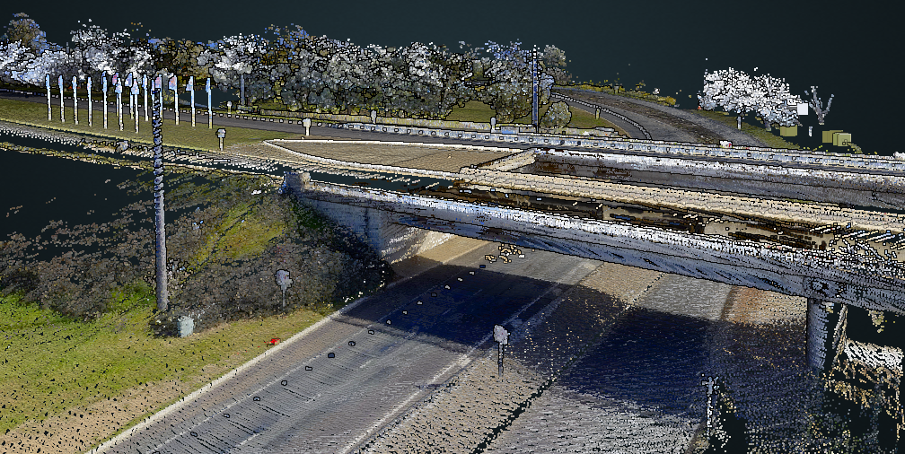
Using lidar for creating digital twin representations of reality
Lidar data delivers powerful 3D modeling capabilities that enable “digital twin” representations of reality. HERE Lidar Data enables users to create a “digital twin” representation of reality with the identification, classification and localization of objects within +/- 2 centimeters of relative accuracy within the lidar point clouds.
The lidar data has been processed to improve quality, colorize the point clouds using the associated imagery, and converted to industry-standard .las/.laz formats. Additionally, accuracy checks are performed as part of the processing workflow. Commercially available software and experience working with lidar point clouds is needed to extract insights from the data, including identification, classification and localization.
HERE Lidar Data supports a colorized feature that infuses each point within the point cloud with an RGB value derived from HERE terrestrial 360 imagery capture for improved visual contrast of real-world objects within the point cloud.
Benefits of HERE’s lidar data
Users can request HERE Lidar Data as-a-service, or they can access the company’s global library of 3D point clouds on-demand via the HERE Platform. What makes this data offering unique is that while governments tend to provide aerial lidar data, this often fails to capture the needed detail at ground level, which HERE terrestrial-based lidar accomplishes. At the same time, the global coverage HERE delivers is a unique selling point as data has been collected in more than 50 countries around the world. HERE are seeing keen interest and uptake particularly among road authorities, departments of transportation, infrastructure planning/management, and architecture/engineering customers.

HERE captures the world’s road networks and urban environments from hundreds of data sources, including its fleet of Lidar sensor and 360° camera-equipped vehicles. HERE utilizes the lidar 3D point clouds as a foundational data source for the company’s various 3D and HD map content products.
HERE and Bentley lidar data partnership
At CES 2022, HERE highlighted the capabilities of HERE Lidar Data in conjunction with its partner discussion with Bentley Systems. Enterprises and professionals can leverage HERE Lidar Data using Bentley’s Orbit 3DM, a cloud-based visualization software, to design, build and operate infrastructure more efficiently, reducing site visits and data collection time while accelerating project design and construction time.
Historically for DOTs, the scale of a city, and the corresponding volume of lidar data, made utilization quite difficult. DOTs have operated within siloed, desktop-based, and isolated data storage environments. Today, Bentley’s Orbit 3DM cloud-based services make HERE Lidar Data access easy, secure and scalable across all departments, users, and devices.

For a DOT, some of the cross-departmental use cases that can be addressed include:
- Fixed asset management: locate, manage, and maintain fixed assets along the road network.
- Federal compliance: report inventory on all roads as required under the U.S. DOT’s Highway Performance Monitoring System.
- Maintenance and state of good repair: identify, catalogue, and prioritize local infrastructure hazards and improvements.
- ADA compliance: verify that the slope and clearance of sidewalks, curb ramps, and pedestrian paths are compliant with the Americans with Disabilities Act.
- Traffic engineering and operations: develop models of intersections for safety studies and crash reports with full geospatial context.
- Surface transportation planning: combine aerial data to assess road conditions and preliminary designs.
Bentley Systems and HERE Technologies are partnering to bring innovative data products and software technology solutions to market. DOTs, Public Sector Agencies, and Architecture, Engineering, and Construction (AEC) companies could benefit from the combined HERE LiDAR data – Bentley Orbit 3DM cloud-based solution, by bringing highly accurate and detailed data at scale to the field.


