

Derived from terrestrial lidar, satellite imagery, terrestrial 360 and aerial imagery, the dataset will help mobile network operators plan, design, deploy and maintain 5G wireless services.
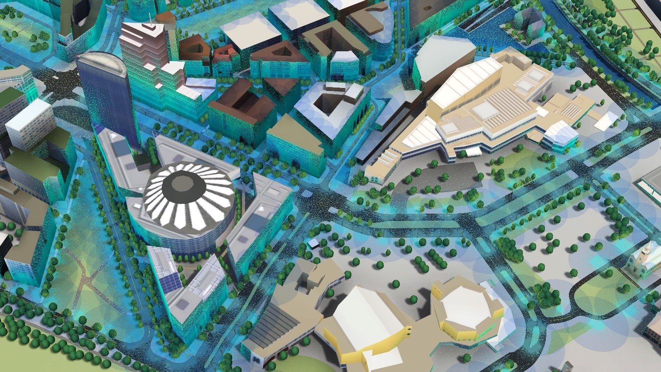
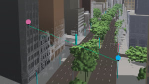
Location data and technology provider HERE has released HERE Geodata Models, a hyper-precise, global, indexed 3D dataset explicitly designed to accelerate the deployment of 5G technologies. Unlike the lower-resolution satellite-based imagery used for 4G planning, HERE Geodata Models provides sub-meter geospatial and geometric precision. This enables site surveys, RF propagation modeling, and line-of-sight modeling to take place on the desktop rather than in the field, saving operators significant time and money. Geodata Models is derived from a combination of terrestrial LiDAR, satellite imagery, terrestrial 360 imagery, and aerial imagery.
Target audience and availability
HERE Geodata Models’ main audiences include mobile network operators, wireless tower providers, GIS and RF tool providers – telecoms organizations involved with planning, designing, deploying and maintaining 5G wireless services and business innovation leaders that will use 5G for edge-computing, support for safer driving, emergency response, and exciting new areas of consumer engagement.
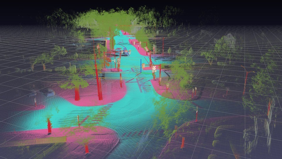
These 3D elements provide the level of detail network planners need when evaluating sites and designing 5G networks. Examples include 3D pole objects are used to model small cell locations for new 5G network topologies, 3D tree objects represent barriers to clear 5G signal line of sight paths, Rooftop of 3D buildings represent good locations for 5G macrocells or some 5G services such as Fixed Wireless Access (FWA) wireless broadband services, these structures represent locations wireless broadband signals can be delivered to.
The product will have a global scope and will be initially available in 50 metro areas around the world. Other key metro areas will follow in the next months. The product coverage plan will be tightly coupled with the 5G services rollout plans of Mobile Network Operators (MNOs) and site location aggregators globally, with an initial 2020 focus in North America, Western Europe, and Oceania. HERE is presently running multiple HERE Geodata Model pilots and PoCs across APAC, the Americas, and EMEAR. The company expects that there will be live 5G networks later this year across all three regions, that were both planned and designed utilizing HERE Geodata Models.
Why 5G cell towers planning requires precise 3D data
 5G mmWave spectrum networks require a substantial number of cell sites, up to 4x to 10x times the number of sites typically deployed per km2 than in 4G/LTE network topologies. Identifying the optimal location of thousands of small and macro cell sites requires rigorous planning and numerous in-person or physical site surveys, adding enormous costs and extensive lead times. HERE Geodata Models can substantially reduce the time and cost related to cell site real estate assessment by supporting remote, centralized digital site surveys. The ability to perform network planning tasks remotely and in parallel for multiple cell site locations can help MNOs accelerate the time to light up services on small and macro cell locations by weeks or even months. HERE Geodata Models is the only solution on the market today with a global scale, supporting the sub-meter geometric and geospatial precision needed for impactful cost reduction and deployment acceleration.
Data collection, production and consistency guarantee
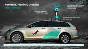 HERE owns its global fleet of terrestrial LiDAR and 360 imagery collection vehicles, with the ability to drive on-demand across multiple cities simultaneously, using multiple cars in each city. Additionally, HERE partners with multiple suppliers of remotely sensed imagery. This combined global catalog of terrestrial and overhead imagery is highly precise, and extremely high resolution, enabling sub-meter geospatial and geometric precision. With regards to data production, the HERE Geodata Model cloud-based workflows and pipelines are architected, and purpose-built to create datasets covering large areas of interest in a matter of days. Once processed, HERE’s highly skilled production center team will be leveraged to provide QA/QC on the datasets. Owning its proper fleet, workflows, and production centers enable HERE to provide the same level of fidelity, precision, and richness in our Geodata Models dataset, regardless of city, geographic region, and developed environment, for example urban, suburban, exurban, or rural.
Usage and third-party software integration
HERE Geodata Models is a dataset that is to be used in concert with third party application software programs for 3D rendering, network planning, network design (RF propagation modeling and line of sight modeling), and GIS. HERE is currently developing partnerships with multiple 5G network design, system integrators, and GIS ecosystem, to address 5G challenges faced by mobile network operators and site location aggregators globally. Distribution and access to HERE Geodata Models will be addressed by multiple mechanisms including, but not limited to the HERE Marketplace, and APIs.
HERE is partnering with multiple parties, including Nokia and Kinetica, to integrate this 3D data into their network planning and design solutions. These offer a range of 5G network planning, network design application software and analytics tools that help MNOs determine where to invest in 5G and what the network requirements would be. These partners use HERE Geodata Models as an input to help MNOs make the right investments. These advanced tools help MNOs accelerate the execution of their 5G network build and deployment activities, as well as help streamline the day-to-day management of the network.
HERE Cellular Signals
Because the transition from 3 to 4 to 5G is not binary, mobile network operators want to utilize the full RF spectrum to optimize service. As operators maintain multiple networks and prepare for the 5G IoT demand, the HERE Cellular Signals product can help by providing information about mobile network performance across 196 countries. HERE Cellular Signals provides multiple layers of rich information associated with cellular networks such as network coverage, available carriers and interface (3G, 4G, 5G, etc.). The product includes signal strength by cell tower in a polygonal configuration. Telecom carriers, Infrastructure suppliers and companies involved in testing and analytics of mobile networks can use Cellular Signals to conduct network tests, validate network investment and performance and evaluate the end-user experience when using a cellular network. When combined with Geodata Models, HERE Cellular Signals can help optimize existing 4G networks and effectively plan the migration to 5G. MNOs can use it to decide where it makes sense to deploy additional 4G hardware today to augment network coverage and/or signal strength that may be weak relative to the competition, or to go straight to 5G, based on a cost/benefit analysis.
Scalability versus high-precision
The key to HERE Geodata Models ability to fulfill both the precision and scale requirements through the proven methodology behind HERE’s architecture, workflows and pipelines. Over the last 35 years HERE has built and maintained the world’s best, most fully attributed map, and is recognized by industry analysts as the leading location platform. The company is extending this same methodology to HERE Geodata Models by developing workflows and pipelines that are purpose-built to support rapid growth via parallel processing. This scalable operations and production architecture encompass everything from collection to engineering to operations and results in the freshest, most scalable, most precise, indexed Geodata set in the industry.
[gdlr_personnel columns=”1″ type=”static” style=”box-style”] [gdlr_tab title=”Eric Van Rees” author_image=”https://sparmsdc-static.s3.amazonaws.com/uploads/2017/06/eric-100×100.jpg” ]Eric van Rees is a freelance writer and editor. His specialty is GIS technology. He has more than nine years of proven expertise in editing, writing and interviewing as editor and editor-in-chief for the international geospatial publication GeoInformatics, as well as GIS Magazine and CAD Magazine, both published in Dutch. Currently, he writes about geospatial technology, programming and web development.[/gdlr_tab] [/gdlr_personnel]

