
Creating thermal-enhanced 3D visualizations at Engensus
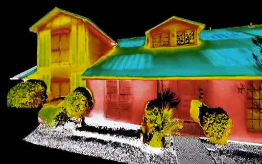
BATON ROUGE, La. – It seems pretty obvious when you think about it: If you can layer digital photos onto point clouds to colorize them, why couldn’t you layer a thermal photo on top of a point cloud and get a thermally colored point cloud?
Well, you can. And Jonathan Coco and his colleagues at Engensus Measurements here did. A spin-off of Engensus Engineering and Consulting that was actually created last fall just after the company bought its first laser scanner (a Faro Focus3D), Engensus Measurements is a six-person team without a background in surveying that’s using laser scanning to take measurements and create 3D models for a variety of clients.
Creating a thermal point cloud was something the team kicked around before purchasing the scanner, Coco said, but “we laughed at it – we were like, ‘no one would ever pay for that.’” But then along came a salesman for Flir who let them borrow a camera for a couple days and the experimentation began.
They ended up buying a E60 for another Engensus project and soon the thermal point clouds were happening and Coco was discovering “it’s got more applications than I ever imagined,” he said. “I’ve got somebody who wants a proposal to help them do 3D thermal scans in full 360 degrees of an entire facility.”
Of course, it’s a government facility and “he can’t tell me everything that we’re going to do,” Coco said with a laugh.
But how did he do it? “Just knowing how [the Faro Scene software]is taking RGB and mapping to XYZ, I said, ‘I think I can do this with a thermal image,’” Coco said, so he went online to the Infrared Training Center first and learned about Thermography.
“You’ve got to know about the complexities of thermography in the first place,” he said, “or you end up with a useless thermal point cloud otherwise. You need to know the thermal camera as much as you need to know the scanner.”
After that, it was fairly simple using the Scene software to colorize the point cloud with thermal images, but you’ve got to take a LOT of thermal photos. Flir’s E60 only has a 320 x 240 resolution, and even the top of the line cameras that Flir makes, the T640, has only 640 x 480 resolution.
“To get a full thermal 360-degree scan? I’m still working on that,” Coco said. He’s looking into different products that allow you to fix a camera at the 0,0,0 of your scan and then slowly take imagery in every direction before stitching it all together into one image. “Because of the low resolution of the thermal camera, though,” said Coco, “the software has trouble lining up all the images and it might take hundreds and hundreds of pictures to get it done.”
He thinks he’s on the right track, though. The latest fly through he put together is here, and he expects to be able to do more robust models in the near future.


