
UK-based GeoSLAM is releasing a new version of the Desktop SLAM registration software, a desktop application that automatically registers point clouds gathered by devices like the ZEB-REVO handheld scanner. The update builds on the previous version by adding a 2D and 3D viewer, user-defined SLAM parameters, and new output options.
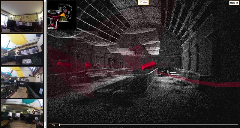
Viewer
The 2D and 3D viewer has been requested often by customers who want to simplify their field workflows. “Customers often want to check the data collected in the field before leaving the site,” says Mark Reid, VP of product management. “It makes sense, therefore, to offer this ability in a single software package rather than relying on 3rd-party viewers.“
Reid also points to the release of GeoSLAM’s ZEB-CAM, which captures still imagery to accompany the lidar-gathered point cloud, as motivation for adding the viewer. “It became a necessity,” he said, “to have a viewer in which the synchronized imagery could be displayed alongside the point cloud for feature identification.”
User-Defined SLAM Parameters
Desktop V3 now gives users the ability to define SLAM parameters according to the work environment. Options include bounding box size, place recognition, and loop closure. Desktop V3 also includes a function for ending processing before the job is complete.
Reid says this will go a long way toward improving SLAM results. “For example,” he explains, “in narrow environments such as manholes or shafts, by reducing the bounding box around the operator it is possible to include more data and improve the resulting SLAM registration. In challenging environments with few features that may typically be prone to registration slip or drift, it is possible to increase the sampling density to identify finer features and optimize the registration.”
Output Options
Desktop V3 adds a wide array of output options, including format, point and spatial decimation, normal, time-stamping, and point rendering. “For the first time,” says Reid, “users can view, modify, and export point clouds from within the same software.”
For more information, check GeoSLAM’s website.


