
Photogrammetry-based bid wins out over lidar-based proposals
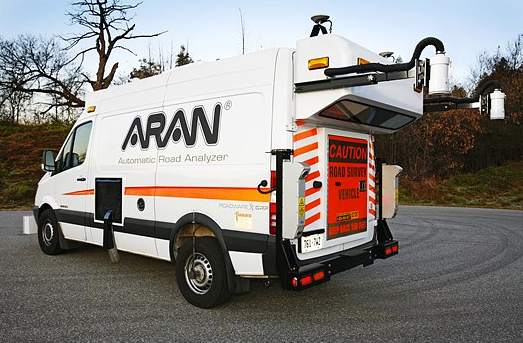
RICHMOND, Va. – Fugro Roadware announced last week it had landed a two-year, $3 million mobile data collection contract as part of the U.S. government’s Strategic Highway Research Program 2. The company will use its Automatic Road Analyzers (known as ARANs) to collect a variety of data at highway speed.
The stated goal of the program is to focus on four areas of the country’s aging roadways: safety, renewal, reliability, and capacity. To that end, the ARAN system uses video-based photogrammetry, GPS, inertial navigation and laser triangulation systems to gather highway infrastructure data along with things like road grade and condition.
“These are the traditional methods we’ve used for many years,” said David Lowe, president of Fugro Roadware. “There’s no lidar.”
He said even within Fugro itself, there can be confusion as to what lidar is and isn’t good for. “There were a number of lidar companies that went for this contract,” Lowe said. “Lots of people got excited about that, but we’re talking about 35,000 miles. It’s not really a suitable technology.” Not only would using lidar for that extended mileage create a huge, and probably unwieldy, set of data, he said, but the processing would simply be too expensive as well.
Further, Lowe said, the ARAN video is calibrated so that one can take 3D measurements as would be necessary for the asset management requirements of both this project and the standard state DOT.
The lidar data “looks so impressive,” Lowe said, “but you’ve got project managers and commercial guys who’ve seen that and been impressed with it, without thinking about the production costs, and what does the customer need and what can the customer maintain. There’s no point in collecting data that you can’t maintain.”
He called lidar “absolute overkill” and “too expensive and laborious” for state DOT asset management programs.
“It’s a nice thing if you’re surveying a bridge, or a new intersection,” Lowe said. “Then it’s worth spending $5000 a mile to survey and extract the data … [but]… we can do a full inventory for under $250 a mile, and the lidar guys can’t come close to us on that.”
However, if the DOT or other asset owner/operator is willing to do the post-processing internally, lidar might creep back into the price picture. Cities like Troutdale, Oregon (see accompanying story), have simply contracted for the lidar data collection at a rate that approaches $25 a mile, with an aim toward processing the data over time with an internal GIS analyst and using it for asset management. Of course, in Troutdale it’s a matter of a couple hundred miles. Nothing approaching 35,000.
And there are reports from Topcon that the Oregon DOT has purchased its own Topcon system that it will be using for asset management purposes (SPAR continues to report on that story).
As technology and the need and desire for accurate 3D data increases it’s likely the methods and costs for documenting city, street and highway infrastructure will continue to evolve.


