
Certainty 3D looks to grow the transportation-scanning market and more
ORLANDO, Fla.—Following on the heels of freeware releases elsewhere in 3D imaging from the likes of Autodesk and Tekla, Certainty 3D has released free software designed to make it easier for surveyors to plan and estimate transportation-based scanning jobs. With TopoPLANNER for static scanning (currently available here) and TopoMISSION for mobile scanning (coming soon), Certainty 3D is trying, said president Ted Knaak, to make its customers more profitable and find more success with laser scanning and 3D imaging.
“People download this and say they’d work on something like this for two to three days, and now they can do it in 20 minutes,” Knaak said.
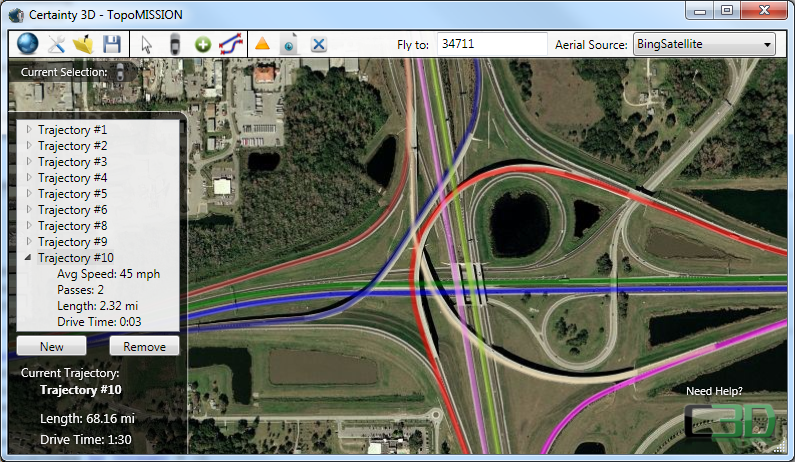
Essentially, the software allows you to input your scanning tools, how much it costs you to scan per hour, how much it costs to put out control, and other variables. Then, you map where it is you’ll be doing your scanning using a map of your choice – Google, Bing, ESRI, etc. – and start using built in tools to plan your scan stations (if you’re static) or your route (if mobile). As you choose your stations and route, the program estimates the time it will take and what it will cost you to finish the job.
Even factors such as traffic patterns are taken into account as part of the estimation.
Once you’re finished, you can save the project as a Google Earth KLM file, or export it to an Android phone where you can link it up with GPS and place your scanner just where you placed it on your computer.
This is something they’ve done internally at Certainty 3D for a while, helping customers who had purchased Certainty 3D’s TopoDOT scan data processing tool suite, said Knaak, “we just finally made it slick. And we’re almost always within a couple of hours of what it really takes to do a scan job like this.”
Knaak says that this will help surveyors with scanners better estimate jobs, make sure of profitability, and streamline their workflow. “Guys are doing this right now, but they’re drawing circles with compasses on printed maps in house,” Knaak speculated. “Instead of printing out their big topo plans, or whatever they had, and drawing circles, now it’s just minutes on the computer.”
So, why the generosity and magnanimity? “It’s in our interest at Certainty 3D for customers to be productive,” Knaak said. “I’ve often said we’ll sell TopoDOT software if the business they’re in is profitable. To be quite honest, for years, scanning wasn’t that profitable. Scanners were only being pulled out every couple of months or so. That’s not a hardcore piece of survey equipment.”
Now, says Knaak, “it’s cheaper, better, faster. Scanners are fast enough now that scanning is going to become more and more profitable.” That grows the number of surveyors doing scanning, and that makes for a larger customer base for Certainty 3D. If some free software helps that along, all the better.
That said, don’t be surprised if you get a call from Certainty 3D not long after you take advantage of the free download. If you want to get that out of the way, you can participate in a free webinar, March 10, at 1 pm Eastern, by clicking here, or you can visit with Certainty 3D at the SPAR International conference in Houston, March 21-24.


