
Designing tunnels, slopes, bridge and dam foundations, and underground and surface mines involves engineering in rock masses. A key challenge in rock engineering design is coping with medium- to large-scale discontinuities in the rock – joints, faults, bedding planes and other fracture types. Characterizing the properties of these discontinuities – orientation, length, spacing, roughness, persistence, aperture, filling, termination – is needed for blast and excavation design, determination of support requirements, cost analyses, numerical modeling and other aspects of design. Last week I heard Dr. John Kemeny, Department of Mining and Geological Engineering, University of Arizona, Tucson, describe to attendees at the Transportation Research Board 5th International Visualization in Transportation Symposium and Workshop, Denver, CO, how rock mass characterization is becoming safer, cheaper, faster and more accurate thanks to 3D laser scanning.
Challenges in collecting this data center on access, safety, time and cost. Kemeny cited a highway widening project where an existing rock slope must be further excavated as a common example. Rock mass characterization often depends on borehole logging and sampling, lab testing, and field mapping and data collection. Traditional field methods of collecting rock mass information are cell mapping – performed by spatially dividing the survey area into cells and measuring gross orientations of primary fracture sets within each cell – and scanline surveying, which records the attitude and location of each fracture intersecting a measuring tape at the outcrop’s base. Both techniques require making detailed measurements along the slope – some data can be gathered from the base of the slope, but where slopes are high or unstable, this is hazardous, time-consuming and costly.
Advantages over traditional field data capture
Kemeny cited an example where laser scanning was used on a roadway widening project in Arizona, and for comparison, traditional data capture methods were used in parallel. Total cost with traditional methods was $6250, mostly for labor, while the laser scanning work cost about $5000 (one-third labor, two-thirds equipment and software costs). The big savings were in time – the traditional survey work required ten person-days to complete, while laser scan deliverables were produced in two days.
Another example is tunneling through difficult and varying rock conditions. In these cases the rock mass needs to be characterized continually as tunneling progresses in order to properly design the tunnel support. With traditional data collection methods, this is difficult to do both accurately and quickly enough for tunneling to progress without delays.
Open-pit mines are a third example. For both blast design and slope stability, it would be useful to be able to completely characterize the rock on all exposed faces as mining progresses. This information could then be entered into the mine database together with geology, grade, throughput, cost and other data. But traditional field methods are too slow to deal with the number of new rock faces created each week in a large mine.
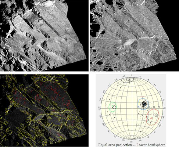
Laser scanning is one of several new technologies that Kemeny sees improving field data collection for rock mass characterization. Others include digital imaging, digital image processing and stereovision. All may be used in conjunction with one another. In particular, laser scanning is often used together with high-resolution digital imaging of the rock face, with the RGB data texture-mapped to the point cloud.
All these technologies make it possible to gather fracture and related information in an automatic or semi-automatic manner, and at a distance from the face. The benefit of automated procedures, according to Kemeny, is to reduce data collection errors by eliminating human bias and standardizing the sampling procedure. Automated procedures can also increase the amount of fracture data collected in the time available – this allows probabilistic engineering design to be carried out in projects where such detailed analysis would not otherwise be cost-effective. Of course the ability to image rock faces from a distance reduces or eliminates access problems and safety risks.
Part 2 in our next issue – post-processing workflow; using the deliverables in analysis and engineering.
Presentations by Dr. John Kemeny and others will be featured in a geotechnical track at SPAR 2007: Capturing and Documenting Existing-Conditions Data for Design, Construction and Operations, March 26-27, Houston, TX.


