

There is still an ongoing debate within and outside the construction industry about its relative willingness to digitize and generally embrace technological advancement, largely stemming from a damning McKinsey report back in 2016. It’s an almost cliche conversation at this point, one that is often oversimplified and with perhaps outdated perceptions still driving conversation. That said, while there have been strides made, there is still room to grow, which was the topic of Geo Week 2023’s opening keynote panel. In that wide-ranging conversation, one of the key themes was that in order to get maximum buy-in, value needs to be clearly demonstrated, something that is happening more as more case studies come out showing the value.
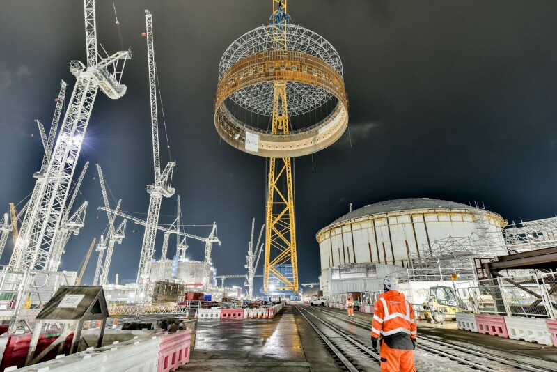
On that topic, one of the most complex construction projects currently ongoing in the United Kingdom is showing off progress they are making by embracing these technological solutions. In a joint announcement from EDF, a British energy company, and Esri UK, the two entities announced expanded usage of a GIS portal created from Esri UK tools is being used in the Hinkley Point C (HPC) nuclear power station project. This is the first new nuclear power station being built in the UK since 1995, and includes 8000 workers on a 450-acre jobsite.
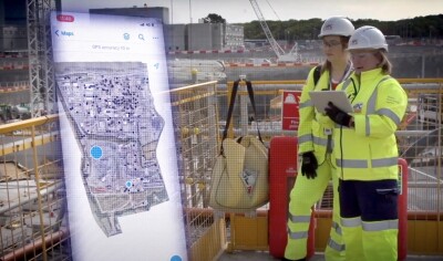
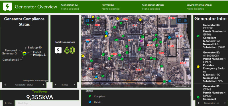
This project officially got underway in 2017, and the collaboration with Esri UK kicked off with a proof of concept three years later. After a year in that phase, an enterprise-wide rollout came in spring of 2021, and has continued to grow into this most recent expansion. We hear a lot in the construction industry, and others, about the vaunted “single source of truth,” which is what this portal aims to create, containing a “central source of all spatial data, maps, apps and dashboards,” per Esri UK’s release on the news. The interactive site map contains over 100 different data layers, including BIM models and CAD data, along with things like construction operations, utilities, and emergency preparedness.
One of the other big pieces of this project which is highlighted in the news release is the focus towards making this portal and the tools within more accessible from a mobile setting. Whereas in the past, contractors may have to head back to the office for things like emissions monitoring, checking a spreadsheet on the office computer, this portal allows for mobile access. In other words, the contractor – or foreman, or subcontractor, or whoever it may be – can complete these tasks in the field, saving time and headaches.
The HPC project in particular is a useful one to show the capabilities of this kind of adoption, given the complexity of the project. A lot of this comes down to just how many people are working on this project (around 8,000), over such a large space. The timing of the project also serves well as a point of reference on a couple of different levels. For one thing, it started shortly after that previously aforementioned McKinsey report, meaning it was a time when there was little digital adoption in the industry. It also had to deal with the COVID-19 pandemic, something that greatly changed the way the industry works, and serves a nice comparison within itself as it operated both with and without these tools. And as nations around the world continue to look for alternative energy sources – this specific project is expected to provide around seven percent of the UK’s electricity upon competition – it’s likely that these types of large-scale projects will only become more common.
In other words, there will be a lot of firms and people in the industry looking to see how this kind of tool can benefit this type of large, complex project. The early returns seem positive, with the biggest takeaway being that the portal gives many people working on the HPC project easy access to the information they need. A lack of useful information has long been one of the reasons these types of projects get delayed and expensive clashes end up needing to be fixed, so having everything in one place will presumably be a growing trend in the industry. Having 3D, interactive maps in place also provides more detail to avoid those clashes and keep things on a better schedule and closer to budget.
All of this was emphasized in prepared comments from Jon Dolphin, the Construction Project Manager and GIS Lead at HPC. He remarked, “The scale of the project presents a complex logistical challenge. Clarity of construction data is critical and the GIS portal provides a single view of this, which drives collaboration as people can see where things are happening and when. Every employee or contractor is making decisions based on the same data. The confidence this generates makes decision-making faster and strengthens the ability of teams to work more efficiently. As a result, we’ve seen improvements in quality, safety and productivity.”
He’d go on to add, “Having one GIS portal for our construction data is immensely powerful for breaking down communication barriers, getting everyone on the same page and improving collaboration. The use of Esri GIS at Hinkley Point C was a cultural shift for many people but new digital approaches soon become indispensable when working on such complex engineering projects.”


