

Pix4D announced that it has been awarded a competitive tender for Deutsche Bahn to provide solutions and services for upcoming railway infrastructure projects through the analysis and visualization of drone images. The frame agreement is a services contract for two years with the option of an extension. Pix4D will deliver premium quality analytics to Deutsche Bahn. Pix4D’s knowledge in drone image processing, photogrammetry, and its expertise in providing software products will build the foundation for the service offering.
Enabling construction progress monitoring and quality assurance
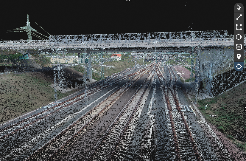
Pix4D will be using its products PIX4Dcloud, PIX4Dmapper, and PIX4Dmatic for processing and analyzing drone imagery for construction progress monitoring and quality assurance. This is an important building block for the digitalization of Deutsche Bahn’s infrastructure management.
PIX4Dcloud, PIX4Dmapper, and PIX4Dmatic are photogrammetry software programs that can use images captured by hand, drone, or plane and turn them into 2D and 3D models or point clouds. PIX4Dmapper is the multi-purpose software for mapping professionals used by more than 10,000 people worldwide. It produces survey-grade results while giving users complete control over the project. PIX4Dmapper is desktop-based, producing 2D and 3D results including volume and distance measurements as well as topographic analysis.
PIX4Dcloud keeps professionals in surveying or construction connected. It is an online photogrammetry platform for image processing, project analysis, and streamlined sharing. Work can be done with the standard PIX4Dcloud plan, or the PIX4Dcloud Advanced option which has more powerful features including a timeline feature, an overlay tool, 2D comparison, and more. The product is dedicated to site progress tracking and project management, with easy online sharing and high accuracy.

PIX4Dmatic is photogrammetry scaling up: it easily handles datasets of over 10,000 images, unleashing the potential for drone mapping in addition to mobile terrestrial surveying. It can handle joint terrestrial datasets of LiDAR and photogrammetry collected with the free mobile scanning app PIX4Dcatch. Users have the option to use the LiDAR, photogrammetry, or a merged point cloud with PIX4Dmatic.
Providing additional services
Pix4D's software products support the entire life cycle of photogrammetric projects starting with the capturing of the data (PIX4Dcapture) over to the processing of the digital images (orthomosaics, point clouds, meshes) up to the quantitative and qualitative analysis of the digital data (PIX4Dmatic, PIX4Dmapper, PIX4Dsurvey).
In addition to the provision of the software-technical infrastructure for visualization and reporting (PIX4Dcloud), the awarded frame agreement mainly includes services for image analysis, report generation and visualization of the construction sites. Possibly, also 3rd party tooling will be used. The decision on which technology to use primarily for remote sensing was made after extensive piloting by Deutsche Bahn. The processing and analysis of the image data follows a schedule agreed between the parties as part of the frame contract.
The framework agreement now enables participation in closed tendering processes for individual Deutsche Bahn projects. It is assumed that within the scope of these projects, various parts of the railroad infrastructure, e.g. tunnels, bridges, track sections, buildings will be monitored and analyzed. Pix4D is not limited to drone surveying. Thus, the company has also extended its offer with regard to mobile data acquisition with the viDoc product in combination with the software solution PIX4Dcatch.
Shaping the future use of drone technology for Deutsche Bahn’s infrastructure projects
The contract will be managed by DB Netz AG, the infrastructure operator of Deutsche Bahn AG, which maintains the largest rail network in Europe that measures around 34,000 kilometers. Deutsche Bahn is committed to climate neutral operations by 2040 and this project is part of ongoing efforts to implement more efficient and environmentally friendly infrastructure maintenance and workflows.
Deutsche Bahn made the following a general comment about AI-based analysis and visualization of drone images for railway construction:
“With this framework agreement, we can provide our project teams an opportunity to better monitor, control and document their construction sites using digital methods. The innovative use and analysis of drone images is an important cornerstone to achieve an increase in efficiency in the construction process and thus to be able to cope with the steadily increasing construction volume in the future."
"With this framework agreement, Deutsche Bahn AG is aiming at taking first steps towards using this innovative technology for the management of infrastructure projects.”


