
Orbit GT offers solution to some public privacy laws
Orbit GeoSpatial Technologies will debut two add-ons for its Mobile Mapping platform – tools for blurring and trajectory adjustment – at next week’s International LiDAR Mapping Forum (ILMF) in Denver.
Belgium-based Orbit sells software for managing, viewing, extracting, publishing, sharing and embedding mobile mapping, UAS and aerial mapping data in workflows.
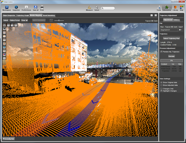
The Trajectory Adjustment tool is an add-on to Orbit’s Mobile Mapping Manager software that lets users adjust the positional accuracy of collected data for higher precision and reliability.
“In any mobile mapping data collection activity, positional accuracy is key and at the same time a variable value,” said Peter Bonne, Orbit’s vice president of business development.
The trajectory adjustment tool, essentially a graph representing positional accuracy, allows the data manager to selectively determine which stretches of data require adjustment.
A selective correction is then measured using ground control points, and the software calculates the adjusted trajectory for that particular stretch. Users switch views between original and adjusted data to check the result before processing the adjustment to point cloud, spherical or planar imagery.
New blurring tools for Mobile Mapping imagery
The Blurring detection and control tools are and add-on to Orbit’s Mobile Mapping desktop software.
“Blurring of faces and license plates is an essential element when sharing street-level imagery with a broad audience,” Bonne said. “Many countries have privacy-related legislation that requires faces, license plates and other identifiers that can link a person to a location, to be obfuscated in publicly available imagery.”
The new tools include automated detection, QA/QC, applying blurring at various levels, and a workflow-based control of error management and updates. Users can choose either to permanently blur the imagery, or let Orbit’s Mobile Mapping Publisher software blur on-the-fly, an add-on to Mobile Mapping Publisher, which retains the original image for later corrections, if necessary.
A second level in Orbit’s blurring tools is a total erase of buildings or areas that are not allowed to be recognized in public imagery such as certain government facilities or military installations


