
Early last Sunday a gasoline tanker truck crashed and burned on a connector ramp near Oakland, CA, in a complex freeway interchange called the MacArthur Maze. The driver walked away with only second-degree burns, and due to the early hour there were no fatalities. But the resulting fire melted bolts and deformed girders on an overpass above the crash site, pulling it off its supports onto the roadway below.
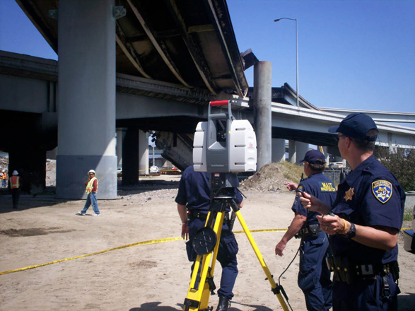
At 7:30 a.m. Lieutenant Dave Fox, Team Manager for the California Highway Patrol‘s Multidisciplinary Accident Investigation Teams (MAIT), called Tony Grissim, Forensic Account Manager for Leica Geosystems, to tell him that a MAIT team from CHP’s Valley Division was heading to the scene to document it using 3D laser scanning. Grissim offered the CHP Leica’s assistance, then started making calls to Caltrans and to Leica employees living near the accident scene. An opportunity was unfolding in which laser scan data captured in a police investigation could also aid engineers assessing damage to the structure and planning the engineering effort to reopen the roadway.
The CHP currently owns five Leica Geosystems ScanStation systems which it acquired late last year, and five MAIT teams are trained in their use. The scene at The Maze would be CHP’s largest and most complex laser scanning project to date.
Scanning team stays just ahead of demo crew
Because of risk of further collapse as the structure cooled, scanning did not start immediately. But no further collapse occurred, and once it was determined that the structure was relatively stable, MAIT members began scanning in mid-afternoon. In the middle of the third scan Leica’s Frank Collazo arrived on scene and offered his assistance to the CHP. This MAIT team had received Leica’s police-specific scan training in January, and needed minimal help. “The MAIT officers were pretty self-sufficient,” said Grissim. “We just offered a few pointers here and there, and suggested setting a few additional survey control points so Caltrans could follow behind with a conventional survey crew and reference the entire point cloud to state plane coordinates.”
Meanwhile Caltrans expedited hiring of a contractor to demolish the collapsed structure. The contractor reached the site during the evening and started demolition – the CHP scanning team was literally staying just ahead of the demo crew, Grissim says.
Scanning eventually concluded after midnight. During this time California Governor Arnold Schwarzenegger and local mayors arrived and toured the damage, and the subsequent news conference with the scene still smoldering in the background was broadcast live.
Continued
Forensic data capture – completeness vs. reopening roads
The CHP’s Lieutenant Fox says that capturing this much detail this rapidly “would not have been possible without laser scanning. We would have taken photographs, then tried to reconstruct a 2D diagram from the photos. But there’s no way we could have captured all the damage without laser scanning.” In highway accident investigations, speed is key. The CHP’s decision to purchase laser scanning equipment last year was driven by the need to complete forensic investigations faster so that roadways can reopen sooner after accidents and criminal investigations.
“Had it not been for laser scanning and the CHP’s agility in deploying it as quickly as they did, they would not have anywhere near the detailed forensic data they were able to capture,” said Grissim. “This event really showcased the convergence of two important scanning markets, those being forensics and transportation infrastructure. The data collected by the police will also be used by the engineering team.”
Repurposing forensic data for civil engineering
On Sunday afternoon Grissim had made contact with a key Caltrans employee with experience in laser scanning, who arrived on site in early evening and provided an external hard drive for the purpose of transferring data from the CHP to Caltrans engineers. Leica offered to provide Caltrans with software and technical assistance as needed during the emergency.
After scanning ended, the CHP copied the data to the Caltrans-provided external drive. The scan data was registered and hand-delivered to Caltrans’ Oakland office later Monday morning by Leica’s Collazo, who also lined out for Caltrans surveyors where the survey monuments were that they needed to tie out for georeferencing the point cloud.
We understand Caltrans will use this data to aid failure analysis of the overpass, and may subsequently scan the remaining structure to help engineer reopening of the highway. (Caltrans owns Leica’s Cyclone software and has staff members trained in its use, although it does not currently own a scanner.) We expect this documentation could prove valuable not only in understanding this event and planning remediation, but also in helping advance work process in civil engineering – bridge engineers used to working in 2D or 1D will be able to see firsthand the value of detailed 3D as-found geometry.
As for Leica’s role in supporting both the CHP and Caltrans in the aftermath, said Grissim, “this was a major event in our own back yard which impacts both the community and our employees. Two of our best customers were involved. Facilitating communication and providing technical resources during the emergency was a no-brainer for us.”
While the criminal investigation is underway, the scan data will be treated as evidence. Once the investigation is complete, Lieutenant Fox says, “the scan data will be published on the Web and made available to the general public” using Leica’s free downloadable TruView point cloud viewer.


