
The sensor itself was just the start.
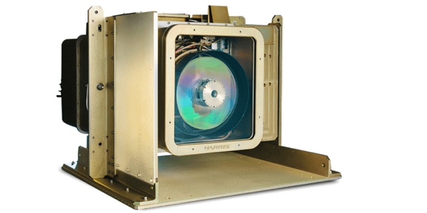
Last year at the International LiDAR Mapping Forum, Harris announced the first commercially available geiger-mode LiDAR sensor. The company is making the sensor available to customers through a service. First, they use it to collect very high definition aerial data (capturing up to 100 points per meter as compared to the 8 points per meter gathered by traditional linear LiDAR) and then they process that data to generate deliverables for each customer’s needs.
The story of this newly available technology made for one of SPAR’s most-read pieces for 2015. In advance of this year’s ILMF, I caught up with the Senior Product Manager for Harris’ commercial geospatial business, Mark Romano. We talked about the year in geiger-mode LiDAR, including unexpected use cases, how the sensor could help bring about truly autonomous vehicles, and what customers really want from sensor technology.
(For more background on Harris’ sensor service, as well as a description of how geiger-mode LiDAR works, see our original article.)
 A Good Year for Geiger-Mode
Since Harris launched their service, they have fielded three geiger-mode LiDAR systems. They have completed work or been awarded jobs from California to Switzerland and Australia. They’ve worked with customers in oil & gas, forestry, land use, flood modeling and more.
“So, I guess to sum it up,” Romano tells me, “the new technology has had a pretty overwhelming global response.”
That response is due in part to the speed and efficiency of the geiger-mode LiDAR sensor, which can collect data for a full mid-sized state at 20 points per meter in a timeframe shorter than a month. This enables Harris to offer fully processed data to their customers at an affordable rate.
In turn, those customers are able to save money on jobs they were already doing. More importantly, though, they’re also able to perform jobs that used to be prohibitively expensive. Romano gives the example of utilities companies, which are now using Harris’ service to build maps of their utility lines in high definition. Previously, that kind of work would have required them to fly each and every one slowly with a helicopter.
What’s more, he said, the high definition data produced by the sensor has enabled some use cases he couldn’t have foreseen.
Better Risk Predictions
For instance, the high-definition deliverables generated from geiger-mode LiDAR data have enabled insurance companies to make better risk predictions.
One area this helps is flood modeling. Generally insurance companies would judge whether a house needed to have flood insurance based on a line of elevation. If your house is below the line, you’re flood prone and you will be required to buy flood insurance.
The system was not very precise, which means that a lot of cases fell into a gray area. “A good example is my house in Florida,” Romano says. “I’m five feet above the flood zone so I don’t have to pay insurance. But is five enough? In some cases, the answer is no.”
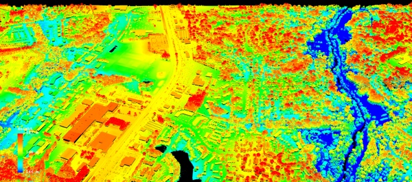
Wide-area flood analysis from high altitude
With high-definition elevation maps generated from Harris’ geiger-mode data, the insurance companies can make nuanced decisions about the risk they’re undertaking with houses near flood zones. “Knowing how far you are above the magic line is important to the insurance company,” Romano explains. “They may look at a million properties in a state like Florida, and half of those might be one or two feet above the magic line. Then, the risk might be higher to the insurance company trying to insure their portfolio than might otherwise be perceived because it’s “in” or “out.” They have different ways of thresholding or managing risk.”
High-definition deliverables help insurance companies to develop better metrics for measuring risk in other ways too. The data allows them to measure damage potential, in detail, for each parcel of land they cover. They can get as specific as calculating the likelihood a house’s roof will be torn off in a hurricane, or that the tree in the front yard will come crashing into the living room.
Geiger-Mode and the Future of Autonomous Vehicles
As amazing as that is, Geiger-mode LiDAR data may have an even more unexpected application: autonomous vehicles.
To navigate a course, an autonomous vehicle needs to know more than your iPhone knows. It needs to know the geometry of the road to make safety decisions, like how fast to take a specific corner in the rain, in the snow, or on a clear day. One source for this crucial geometry? Elevation data derived from geiger-mode LiDAR.
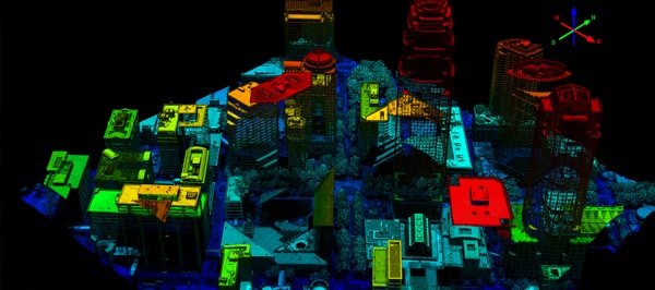
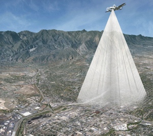
Urban detail gathered from 17,000 feet
This same elevation data may even help to maximize the efficiency of your car. “Some day,” Romano tells me, “you’ll be able to say, ‘I want to get from here to there and I want to use the least amount of energy, and to do that I’m going to use a route that doesn’t rise and fall as much as this secondary route.’ “
Elevation data is crucial to developing the databases that enable autonomous vehicles to operate safely and navigate correctly. As a result, Romano tells me, we’re going to start seeing all automovie companies buying high-definition elevation deliverables.
“These databases are creating this huge new market space,” he says. “Elevation data is going to play a very large role in that process.”
More than a Different Kind of LiDAR
When I asked Romano if there was any reason a customer would rather perform the mapping and processing himself, he said it’s possible–but unlikely. That isn’t the trend in the industry, he told me, and it never has been. In his experience a majority of customers want processed deliverables, not raw point clouds. Answers, not data.
This is the ideal market for a technology like geiger-mode LiDAR, which collects data that can be processed into different deliverables for each customer’s needs. “Our goal,” Romano says, “is to build a large repository of data that has multiple use purposes. So if we fly parts of states, or statewide collects, we can license that data to many customers for many uses.”
When Harris does state work this year, Romano says, they’ll use the same data to extract deliverables at 8 points per meter for the State, but then they’ll carve out rights of way for utility customers at a much higher resolution. “Because of the way we collect data, and how the sensor works,” Romano says. “We can output different deliverables from the same data to serve other customers.”
In other words, they can provide answers.


