
Targetless, cloud-to-cloud registration in real-time
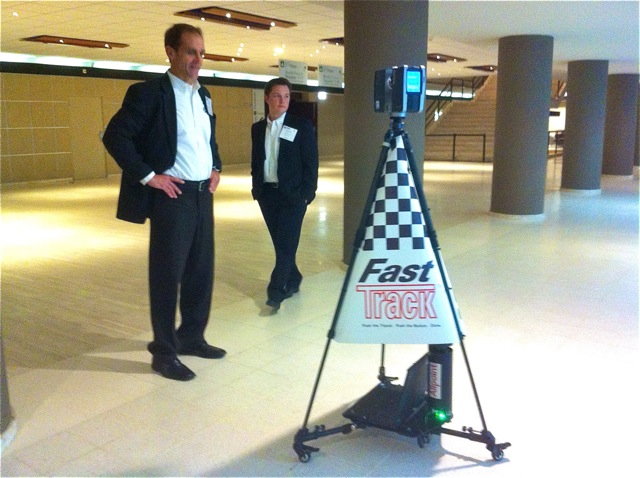
THE HAGUE – “FastTrack is a combination of a lot of things we’ve learned about the problems in the laser scanning industry,” said Aaron Morris, CEO of Allpoint Systems, by way of introducing his new FastTrack product. What is it? Well, it’s a rolling three-wheeled cart with a laptop on board, software developed by Allpoint, and a mounting for the laser scanner of your choosing.
Here at SPAR Europe, where the product was announced, a Faro Focus3D was mounted on day one.
What does it do? That’s the important part. It allows you to rapidly scan from station to station with a terrestrial scanner, while building a completely registered point cloud along the way in real time.
At SPAR International, Allpoint featured something similar, a robot that could be programmed to move from one scan station to another. “That was great,” said Morris, “but the applications have certain types of problems [in the BIM and forensic markets, for example], and the robot system itself is big and bulky and requires a lot of hauling around.”
FastTrack is built for mobility and speed, designed to rapidly acquire large datasets and allow for users to do QC in real time, so that no one discovers they’ve missed a spot when they get back to the office.
“The traditional surveyors are not our customers,” Morris said, though he’d be happy enough if they were. It’s just that Allpoint solutions tend to target “people who know nothing about laser scanning, but see the value and want to get into it. But they don’t want to do targeting and all those various things. So, we’ve taken all of these pieces and created a package that’s automatic … as you’re moving the scanner around, it does the download, does the import, does the registration. But it also gives you your progress. It tells you how you’re doing. If there’s a bad scan done, if you’ve moved the scanner too far, it tells you right there. This will help a person who’s new to scanning get the best possible data set.”
Further, it connects to Allpoint’s cloud-based Insight product that allows for web-publishing. “As soon as you collect that last scan,” Morris said, “you click ‘publish’ and by that night it’s up online and everyone can check it out and see what was captured. It’s an extremely fast field-to-web solution.”
FastTrack makes use of simultaneous localization and mapping technology (learn more about it at Open Slam), combined with traditional high-end terrestrial laser scanning to create a solution that is both accurate and knows where it is in space without the use of GPS or an IMU.
Morris said he’s willing to talk accuracy with the orneriest surveyor. “Time after time,” he said, in referring to the Scan-time software product that is at the heart of FastTrack, “accuracy has been part of our sales process, where we have to go through the vetting process … We’ve made sure the accuracy is solid.”
Sound too good to be true? The system does have limitations, of course. It’s really only effective on one plane. You can’t take it up a flight of stairs and expect the real-time registration to work on your next scan. If there are very few features in the scene, you might have to introduce some (call them “targets” if you want, but they can be just about anything). If the scans don’t overlap by enough, the system won’t work correctly.
But the system also continues to be a work in progress. “We’re actively working on version 2,” Morris said, “which you can pick up. And then version 3 you’ll be able to take anywhere … You can say anything is a work in progress, but at some point, you ask yourself if the device has enough value to go into the market and if the answer is yes, you put it out there. Does it have every feature we want? No. But we’re at the point where we need people using it to prioritize the next features.”


