

Article by Ada Perello, EAASI
In the heart of Iceland's ever-active landscape, where volcanic activity is a constant concern, the Icelandic Institute of Natural History (IINH) plays a vital role in monitoring and understanding the region's geological dynamics. In collaboration with leading institutes in geohazards in the country, the IINH operates a cutting-edge photogrammetry lab tasked with mapping the evolving environmental changes and lava flows.
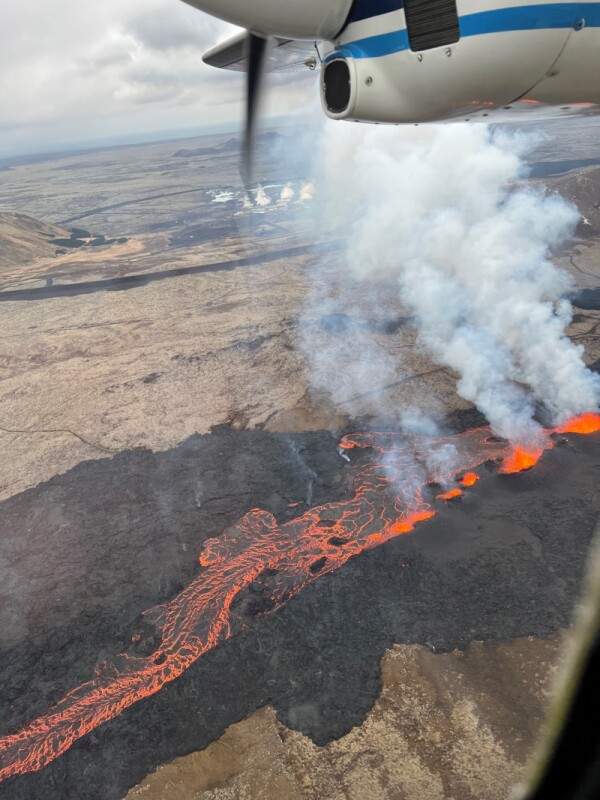
In December 2023, Grindavík, a town on the Reykjanes peninsula southwest of Reykjavík experienced a significant volcanic event. A fissure eruption added to a series of volcanic incidents that have affected the region.
As a result, more than 4,000 people were displaced, and many houses and buildings were damaged. However, Icelanders are determined to fight back. They initially evacuated, and now want to protect their homes and businesses, but it's hard to predict when they can return.
Directed by Birgir V. Óskarsson, the photogrammetry lab of the IINH swiftly mobilized to document the evolving terrain. By accurately mapping the flow and measuring the area and volume of the lava flows, the authorities can better mitigate and predict the hazards.
Harnessing Crewed Aerial Surveying
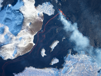
High-resolution nadir imagery is essential for monitoring the hazards and allows the photogrammetry team to generate Digital Elevation Models (DEM), orthoimages, and 3D mesh models – all to follow the progress and evolution of the lava field. The lava effusion rate, or the amount of lava discharged per unit of time, is determined by comparing DEMs of the lava at different intervals. This comparison also allows the team to detect changes in the lava fields and potential obstructions beneath the crust, such as inflation.
The IINH photogrammetry team opts for airplanes with medium-format cameras for their ability to cover extensive areas quickly, surpassing the efficiency of drones. Airplanes can operate at higher altitudes, typically avoiding airspace congestion with drones, helicopters, and smaller aircraft. Additionally, deploying drones from the ground poses challenges, especially in hazardous volcanic conditions where drone operators would risk proximity to dangers.
Yet, amidst the unpredictable nature of volcanic activity, the team encountered numerous challenges. Flight plans, meticulously crafted to navigate the skies, often had to be adapted on the fly to account for changing conditions. Cloud cover and turbulent winds added to the complexity of the missions, requiring adaptability and quick thinking from the surveyors.
To address the requirements of the photogrammetry team, the company Phase One introduced a PAS system, featuring a camera housed within a compact system frame, further stabilized by a SOMAG stabilizer. Integrated GNSS and inertial systems enhance precision. This integrated setup facilitates efficient aerial operations, enabling the team to swiftly cover large areas in a matter of minutes.
This solution allows the team to promptly share their findings with various agencies, including civil protection and rebuilding companies for hazard assessment. Data is transmitted to civil protection shortly after surveys, thanks to the system's streamlined processing. Automation of image capture and stabilization minimizes processing time, ensuring images are accurately aligned and overlap sufficiently.
Establishing a simplified process will also make it easier for other people to operate the system, such as when a long-lived eruption necessitates a larger team to rotate shifts.
In conclusion, the PAS system has become a vital tool for monitoring volcanic activity in Iceland, with plans for broader application in landslide, glacial monitoring, flood surveillance, and remote area surveying. Future endeavors encompass studying glacier surface changes caused by geothermal anomalies, indicative of potential subglacial volcanic activity and ensuing hazardous floods. This highlights the photogrammetry team's adaptability and innovative use of technology in diverse scientific pursuits.
★★★
About EAASI
The European Association of Aerial Surveying Industries (EAASI), established in 2019, unites over 50 companies to advocate for the aerial surveying sector in Europe. Inspired by the success of MAPPS in the US, EAASI fosters collaboration among industry leaders and champions the significance of aerial surveying. EAASI brings you articles to showcase compelling use cases of aerial surveying and airborne data, highlighting the industry’s innovative contributions and advancements.

Ada Perello is the Communications Manager of the European Association of Aerial Surveying Industries (EAASI). She has worked in external communications for several organizations, including the International Maritime Organization (IMO), the Food and Agriculture Organization of the United Nations (FAO), and the private sector. Ada holds a Master's Degree in Journalism and a Master’s in International Business Administration.


