
Hires industry vet Boyer; adds Riegl VQ-480 and Houston-area location
CEDAR FALLS, Iowa – Aerial Services, armed with five planes and a helicopter, has been in the aerial mapping business since 1967, with thousands of square miles of orthophotos, vector mapping and more under its belt. But even a company with a long client list can’t stand pat in today’s technology marketplace.
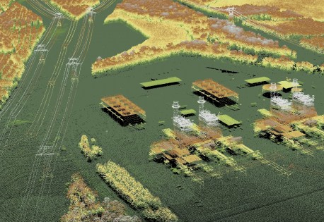
“The next progression is lidar,” said Chuck Boyer, who’s been brought on board as director of business development, tasked with heading up a new location in the Houston area and driving new lidar collection business. Chuck has a new toy to play with, too: Aerial Services acquired this month a Riegl VQ-480 (see the spec sheet here), which allows the company to more aggressively pursue corridor mapping, transmission line inspection, and mining applications, among many others. Though the company has been collecting lidar data for almost a decade, this gives Aerial Services much greater flexibility, Boyer said.
“We can mount it in the helicopter, and get very high accuracy there, anywhere from 20 to 40 points per meter,” he said, “or we can go up to 2,500 feet in a fixed wing. It’s great for extremely high accuracy jobs or, say, scanning a small city. Trying to do county work, or multiple counties, at 2,500 feet might not be cost effective, but city projects, if they have levees or something like that, where they want comparative analysis to see if anything has changed over time, this scanner is perfect for that kind of work.”
Boyer was most recently regional sales manager at Terrapoint (acquired by GeoDigital back in June) for five years, but he said it’s more his sales and customer management background than his geospatial background that the 35-employee Aerial Services values. Or, rather, the combination of the two.
If you’re too much of a scientist selling the services, he said, you get caught up in the capabilities and the details, and forget to make sure the customer understands what he wants and what he’s getting. If you’re too much of a salesman, you over promise and under deliver, or deliver the wrong thing.
“I had a boss once and he figured he flew one of the first lidar missions,” Boyer said. “He told me he thought he’d probably spend his entire career taking the ‘lie’ out of lidar.” Whether it’s vendors winning a power-line project based on their promise of 40 points per meter when half the points would do, “because more points sound better,” or asset owners asking for data in a format that doesn’t work for the engineering firm they want to pass it off to, education of the market is crucial for market growth, Boyer said.
“You have to have the relationship with the survey manager, sure,” Boyer said, “but then they have to work within their organization to say, ‘if we do this we’ll save money and let me show you how.’ And there are going to be some growing pains that they’ll have.” Today’s lidar service provider has to help with that process.
For the large part, Boyer said the company’s customers tend to be government entities – municipalities and departments of transportation – but he said the private sector is starting to come around. Oil and gas companies have been receptive, and those with large construction projects who need to know the dirt that was supposed to have been moved was actually moved. Mining, too.
Are companies with the new terrestrial mobile scanning units, who also have targeted the mining industry, starting to be more in competition with the aerial market? Boyer doesn’t think so. “They complement each other really well,” he said. “You can fuse the data.” Maybe aerial lidar scans miles of roadway, but you bring in mobile scanning for those places where you need finer detail, he said. “At 70 to 100 points per meter, you can derive soft break lines that give you a lot more information than someone flying at 1,000 to 2,500 feet,” Boyer said.
In the end, “it’s a measurement industry,” he said, “and you’re dealing with the accuracy of the measurement. That’s what I love about Aerial Services: Because it’s a measurement industry, I, as an employee, am held accountable for the accuracy of what I tell a customer. And you would hope that everyone’s like that, but, unfortunately, that’s not necessarily the case. So, with people getting more and more sensors out there, you just have to make sure that not only is there education on the part of the customers, but also that the vendors will deal with the customers fairly and give them what they’re paying for.”


