
Active quality control of construction projects and accurate documentation of project history are key objectives of a research initiative at Carnegie Mellon University. Dr. Burcu Akinci, associate professor of civil and environmental engineering at CMU, detailed for SPAR 2007 attendees how the project, Advanced Sensor-Based Defect Management at Construction Sites (ASDMCon), developed work processes that use integrated project models, 3D laser scanners and embedded sensor systems for early defect detection and management at construction sites.
Funded by a five-year National Science Foundation grant, the research project began in 2001 and was carried out by faculty and students from CMU’s Civil and Environmental Engineering department, School of Architecture, and Robotics Institute. Many key participants are also active in Carnegie Mellon’s CenSCIR – the Center for Sensed Critical Infrastructure Research.
Dr. Akinci lists challenges that the project set out to address. “The status of work-in-place at construction sites changes as construction projects evolve over time,” she notes. “Most current surveying and quality control approaches provide sparse data about work-in-place – this can limit a project team’s ability to easily identify and manage defects early during construction, and to actively control and manage construction projects.” What’s needed for active control of project quality? Three things – “frequent, accurate and more complete assessment of as-built conditions at construction sites, identification of critical spatio-temporal deviations of work in place, and assessment of whether these deviations constitute defects during a construction project.”
What the ASDMCon team realized is that advances in generating digital 3D environments with laser scanning have created opportunity to explore the technological feasibility of more frequently gathering accurate and more complete 3D as-built data during construction than was possible before.
Continued
Construction QC challenges
“Why did we end up looking at construction QC?” Dr. Akinci asked. Because there are defects that go undetected on the job site if you don’t search for them accurately.” The main causes of construction errors – human error and changing environmental conditions – are uncontrollable, Dr. Akinci notes. Thus, “improving the inspection process and the assessment of as-built conditions is critical to prevent the propagation of defects, reduce costs and time for rework, and prevent defects from occurring.”
Current inspection approaches are error-prone since they rely on inspectors’ experiences, Dr. Akinci notes. She described instances where “multiple inspectors went to a job site to identify known defects, and came up with different results.” Reasons include the differing experiences of the inspectors, and the “large amount of project information, for example project-related construction specifications, that they need to consider during inspection.” Dr. Akinci also cited research indicating that “54% of construction defects are attributed to unskilled workers or insufficient supervision of construction work.” She sums up, “Human error will always occur.”
The answer pursued by her project? “A formalized inspection system that will enable inspecting construction sites more thoroughly, and reasoning about construction specifications more systematically.” This includes “helping to collect information, to manage the collection process, to reason about the collected information with respect to the construction specifications, and to identify deviations and construction defects.”
Why now? “With new reality-capture technologies available, like laser scanners and embedded sensors, new possibilities for collecting large amounts of construction site information are evolving,” she says. Laser scanners can be used to collect 3D information about the construction environment, and embedded sensors can help in collecting and monitoring material information.
“However,” she continues, evaluating all this sensor data “is still a critical task, and is currently being done manually.” She identifies three major limitations: “One, inspectors still focus on only a small sample set of the as-built data available at a given time, which can result in overlooking some errors. Two, it still relies on inspectors’ knowledge about specifications and on their previous experiences. Three, manual evaluation of the data is time-consuming.”
The solution developed and piloted by the ASDMCon project is “an automated defect-detection system that is capable of reasoning about specifications, the designed and the collected as-built information.” Key capabilities – “to model and reason about all relevant project-related design, schedule, construction specification and as-built information to identify possible deviations in the as-built environment.” The goal – a system “able to provide the inspectors with the necessary information on the construction defects that are identified automatically.”
To accomplish this, the project pursued three specific objectives: “One, developing general and computer-interpretable representations of construction specifications to enable automated reasoning. Two, developing related reasoning mechanisms to identify deviations, assess the deviations identified, and if necessary classify them as construction defects. Three, formalizing the scheduling of inspection tasks based on the construction specifications modeled and project-specific design and schedule information.”
Continued
Characteristics of infrastructures and construction sites
“What are the challenges of using laser scanning on-site during construction projects?” Dr. Akinci asked. “We have massive structures that yield large quantities of data. Especially for quality control, we can’t do sparse scanning – it needs to be high-resolution.” Also, construction sites change with time, often rapidly. “For QC during construction, we need to proactively plan for scanning operations so we can effectively capture the spatio-temporal changes taking place.”
Too, there are often stringent tolerance requirements, “which result in the need to hold high accuracy in the data.” Dr. Akinci described one research case where a transportation application required “a maximum one-eighth- to half-inch deviation over a ten- to sixteen-foot length.” Similarly, there are often “anchor bolts that need to be located, again resulting in a need for very high-resolution data collection – which means large amounts of data that need to be processed during construction.”
A final challenge – “job sites can be very messy.” In one case her team used an approach it had developed to plan the scanning process before going on-site, “but we went back to the job site and found very different conditions than expected. So you want to come up with a plan, but then also be able to adjust your plan to make sure you collect the data you need – not all the data you possibly could collect.”
Advanced sensor-based defect detection and management on construction sites
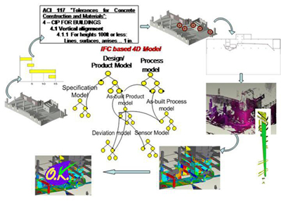
“We see deviations from the design occurring on almost every job site,” she says. “Our goal is to be able to search for them automatically – we’ve been trying to formalize this process. Since we’re looking at construction sites and facilities, we start with a 3D as-designed model. Then we add schedule information; what you get at that point is the 4D model. If you have that model – and now industry is starting to use 4D models – you have a good plan you can use to figure out which components will be built when. And based on that, you can start planning scan operations.”
Given the broad range of construction specifications and defects appearing nowadays on construction sites, Dr. Akinci says, the project decided to focus its research on “modeling of specifications for cast-in-place concrete construction in commercial construction projects, and automated reasoning about these specifications from the perspective of a general contractor’s construction inspector.”
Scan planning based on specification model
“It turns out that specifications can be modeled using some behavior, feature and property lexica,” Dr. Akinci reports. “We link that information to the design model and use it to identify what components we’re interested in, what features of those components, and what levels of accuracy are needed when we scan.”
This information, in turn, informs planning of the scan process. “With this data, we start creating these configuration spaces around the specified features and accuracies. What you see here [Figure 2] is that, for this particular scanner to be able to scan this component with the level of accuracy needed, then the scanner should be positioned in the space as shown.”
How does this work? “We add the specifications to the models because the specs provide information on what features of an existing structure are of interest and needed resolution of the data to collected – how close the laser scanner should be to the target component to get the accuracy that is needed. Once 4D models are augmented with construction specifications, using the knowledge about what’s going to be built when, and what the tolerance requirements for those components are, and what features are of interest for data collection, it is possible to create target lists of what to scan, and of the accuracies needed.” Thus, “with this data, and using the specifications provided by the manufacturer of any scanner, it is possible to come up with an initial plan of where to position the scanner to get the data that is needed, at the level of detail needed.”
“My students are pretty knowledgeable about using laser scanners,” Dr. Akinci notes. In the example shown, “given the target features for data collection, they came up with a projected plan of eight scans. But through a scan plan process, we were able to reduce that to three scans, and in just this small area, we were able to save about 25 minutes out of a projected 40 minutes of scanning effort, and still get all the data we needed.”
Continued
As-built representation
To carry out as-built modeling, says Dr. Akinci, “we start with point cloud pre-processing, then registration. But we also want to have some kind of intelligent representation of these components and have an automated way to extract this representation from point clouds.” So, starting with raw point clouds, “the second level of intelligence is to be able to say, ‘These point clouds grouped together are wall point clouds,’ for example. Then the third level of intelligence is to create a surface model so that I can say, ‘This model is the wall that is on grid line XX in the design,’ and can represent it accordingly in an as-built model.”
To this end, the team executed a case study – “a warehouse project where we scanned the area during construction.” Figure 3 (left-hand image) shows “a column that was repeating in this project – this was the design model. Then this [right-hand image] is the range data that we got from laser scanning. Then, the case study showed that it is possible to use the design information to automatically identify these components in the scene. In this case study, even though there was a small change in the design that never got captured in the design model, the algorithm still worked in identifying these components in the scene.”
Dr. Akinci summed up: “Laser scanners provide a great opportunity for active quality control during construction, and for accurate as-built modeling and detecting spatio-temporal deformations over the service life of infrastructure systems.” However, for greatest benefit, “Utilization of laser scanning should be carefully planned on job sites.” And still, “There remains a need for better characterization of the accuracy of data collected and processed.”
About the ASDMCon Project
Participants in the ASDMCon project included the following individuals. Faculty – Civil and Environmental Engineeering: Burcu Akinci, Jim Garrett; Robotics: Daniel Huber, Martial Hebert, Scott Thayer; Architecture: Ramesh Krishnamurti. Postdocs and Research Scientists – Robotics: Daniel Huber, Nicolas VanDapel, Graduate Students – CEE: Frank Boukamp, Chris Gordon, Pingbo Tang; Robotics: Ed Latimer, Rajiv Saxena, DeWitt Latimer; Catherine Lyonns, Architecture: Kuhn Park, Kui Yue. Undergraduates – CEE: Malena Yablinsky, Sarah Schrass, Martha Alunkal; CS: Sung-Joo Lim, Giancarlo Dozzi, Lisa Michaux-Smith, Jennifer Lin; Architecture: Don Havey, John Oduroe. The project is funded by a five-year grant from the National Science Foundation under the Information Technology Research initiative, starting September 2001. The grant number is NSF-CMS-0121549. NSF’s support is gratefully acknowledged. Any opinions, findings, conclusions or recommendations are those of investigators and do not necessarily reflect the views of the National Science Foundation.
About CenSCIR
Carnegie Mellon’s CenSCIR – the Center for Sensed Critical Infrastructure Research – aims to deliver what it calls “electronic nervous systems” to critical infrastructure through the use of sensor-based systems, processes and technologies. The center’s research explores requirements for these technologies, provides design guidance for it, and provides justification for implementers, operators and future designers of these “sensed critical infrastructure” systems. Executive director is Matthew Sanfilippo, formerly director of applied technology for Michael Baker Corporation, who is also co-associate director of PITA (the Pennsylvania Infrastructure Technology Alliance). Faculty co-directors are Dr. Jim Garrett, Professor and Head, Civil and Environmental Engineering, and Dr. José Moura, Professor, Electrical and Computer Engineering, Carnegie Mellon University.


