

I had heard murmurs about the introduction of a new GNSS rover equipped with a downward-facing offset laser and couldn't wait to see it in action. My anticipation was met during the FIG (International Federation of Surveyors) 2023 Working Week in Orlando. Together with a surveyor acquaintance, we spotted the Venus Laser RTK at the SinoGNSS/ComNav booth in the exhibit hall.
Despite its compact size, resembling a can of pop with its helical antenna, it promised a remarkable shift in the shape and weight of a can of pop. My first impression was that if it performed as advertised, it could provide a lot of new operational possibilities for field mapping and surveying. To the best of our knowledge, this is a pioneer in the market. A brief walkthrough of its features spurred us to borrow one for a thorough test drive.
The Basics
In recent years, GNSS RTK rovers across the industry have become smaller, yet more powerful. Venus RTK is a great example. As outlined in the available specifications (linked above), the device weighs in at only 380g (under one pound) and supports 1590 channels, accommodating 20 signals across multiple constellations, including GPS, GLN, GAL, and BDS, plus other regional constellations such as NavIC (IRNSS), QZSS, and SBAS support. It comes equipped with no-calibration (IMU-based) tilt, NFC and Bluetooth connectivity, an IP67 rating safeguarding against dust and moisture, a battery life extending up to 20 hours, and a resilient working temperature range spanning from -20°C to +50°C. These characteristics hold it in good stead against its high-end contemporaries, as our tests readily corroborated.
The standout feature, without a doubt, is the downward-facing laser, thoughtfully offset from the axis of the antenna phase center (PCO) and antenna reference point (ARP), allowing it to function seamlessly even with a pole attached. The Venus is rechargeable via USB 2.0, reaching full charge within a 4-hour timeframe.
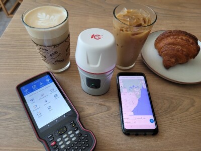
At present, the Venus rover supports SinoGNSS Survey Master field software. Having previous experience with Survey Master, I found its interface intuitive, offering adept controls for managing the tilt and laser functionalities. The test utilized a borrowed SinoGNSS R60 data collector, and we further assessed its compatibility with an Android phone. Lacking a radio-equipped base for the trials, we connected to a nearby fixed base, situated 3km away, through NTRIP and a Virtual Reference Station (VRS) network solution.
Standard Rover Testing
To gauge its proficiency as a standard rover, we mounted it onto a 2m pole and conducted multiple measurements at various established marks, deliberately disabling the tilt function. The inverses between our shots were cross verified against the published values of a local National Geodetic Survey (NGS) calibration baseline, revealing accuracies within 1cm horizontally and 2cm vertically. This level of precision echoes the published specs of the Venus and is consistent with the of several high-end rovers we have previously encountered.
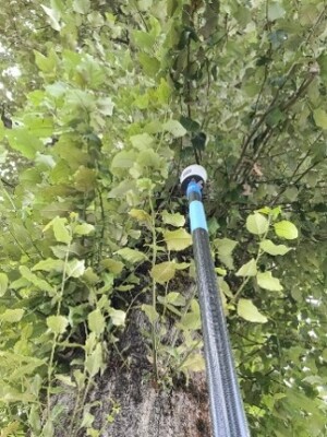
Its ability to perform under tree canopy was good. Light, moderate, or even in thick canopy. For instance, right up against a large tree. The device achieved rapid fixes, without accruing substantial errors. It also exhibited good resistance to multipath interference from nearby sources. Inclusive in modern rovers, is improved multi-path rejection, due in part to multiple constellations and signals.
An amusing side note: During our tests, a missing adapter compelled us to craft a makeshift version using a 5/8-11 sleeve and an 8mm bolt, adjusting the pole height in the software. There is a standard adapter for Venus, but this “MacGyver’d” solution worked well.
Tilt Tests
For tilt tests, we set a mark and did a series of bubble-plumbed observations to establish a reliable "zero" value, followed by observations at varying angles of tilt. Our results revealed an error margin within the range of 1cm H/2cm V at 5 degrees, 2cm H/3cm V at 30 degrees, and 3.5cm H/4.5cm V at 45 degrees. Some of these values may reflect standard GNSS error margins, yet overall, the tilt function showcased promising performance, aligning well with other tilt-enabled rovers we have encountered.
Tilt Plus Laser
Engaging the laser automatically activates the tilt function, a necessary integration to ascertain the laser axis's orientation relative to the PCO/ARP axis. The laser projects a sharply defined green spot onto the ground, visible even under the bright sun. Our tests, conducted both by hand and using a pole for stability, demonstrated satisfactory shot groupings within 1cm and 2cm respectively.
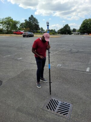
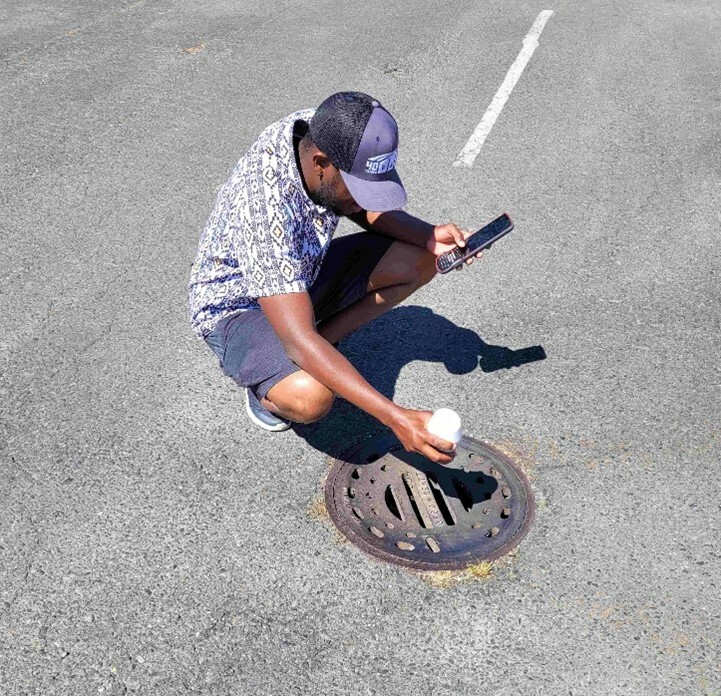
Utilizing a pole to steady the device, especially when aiming at inverts in maintenance holes or inlets, proved to be a prudent approach, ensuring greater accuracy and consistency.
The laser's range, as per the specifications, extends to 10m, a detail our quick tests corroborated successfully. Although we did not subject the battery life to a prolonged test, an 8-hour run with the laser activated did not encounter any issues. Regrettably, as we were testing during the peak of summer dryness, we missed the opportunity to test its performance through shallow waters, a scenario common in catch basins and maintenance holes.
An enjoyable facet of the testing phase involved utilizing the laser to measure inverts through the grates of several catch basins without the need to remove the lids, potentially a considerable time-saving advantage in actual field operations.
Potential Productivity Gains
As a standard GNSS rover, the Venus showcased commendable performance, equating to or even surpassing other high-end models in various aspects. The additional laser functionality emerges as a promising tool, potentially elevating field task productivity levels significantly, especially in locations challenged by limited GNSS signals, such as under roof eaves, alongside buildings, under dense vegetation, or for measuring inverts.
For a first-of-its-kind device, the Venus exceeded our expectations, offering a refined workflow through its supporting software and proving to be a genuinely enjoyable tool to operate (quite fun, actually). The combined functionalities of tilt and laser present an opportunity to significantly reduce field operation time where applicable, signaling a promising future for this innovative device.


