
Pix4D’s updated desktop software addresses ‘soaring demand for GIS data’
Pix4D, a Switzerland-based software startup, has released version 2.2 of its Pix4UAV desktop software, which combines thousands of aerial images taken by unmanned aerial vehicles (UAVs) into professional and accurate georeferenced images, 2D maps and 3D models.
Just two years old, Pix4D started as a spin-off of Switzerland’s Ecole Polytechnique Fédérale de Lausanne (EPFL), and said it is now the main supplier of professional UAV processing software with a goal of making civilian UAVs, or drones, “the next-generation mapping and surveying tool.”
“With the fast technological advances in miniaturized autopilots and digital cameras, lightweight autonomous flying platforms are increasingly used to generate up-to-date and detailed environmental maps and geographical information data,” the company said. “Furthermore, recent changes to the regulatory framework for civilian drones will drive UAV adoption and help address the soaring demand for GIS data.”
Pix4D sells its products to UAV manufacturers for bundling or directly to farming, mining, construction and exploration companies that need to create a timeline of 3D images.
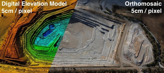
Pix4D said its roster of clients include the United Nations and global mining companies but is mostly comprised of surveying companies, which benefit from huge productivity gains by allowing them to survey large areas and volumes, with up to five centimeters accuracy, within minutes instead of days of traditional ground measurements.
The company provides its OEM-based software for particular professional drones such as Gatewing’s Strechout, Stretchout Cloud and senseFly’s Postflight service and Terra 3D.
New v2.2 features
New features and processing options of v2.2 of Pix4UAV include:
- Point cloud filtering and smoothing: allows users to choose their own filtering and smoothing options or lets Pix4UAV use optimal options automatically
- Enhanced GCP (ground control points) editing: choose between 2D and 3D GCPs, set up GCPs either for calibration or verification and select between global or local coordinate systems to achieve the most accurate results with very limited manual intervention
- New output formats, including .LAS
- Improved processing for faster results, more detailed Quality report, improved project merging
$3.5 million investment
Pix4d received a $3.5 million investment last July from quadcopter manufacturer The Parrot Group, the Paris-based manufacturer of the smartphone-controlled quadrocopter for augmented reality gaming, to speed up the development of its GIS software for UAVs.
“Parrot’s investment enables Pix4D to strengthen its position as the leading software provider for processing aerial images collected by professional drones,” said Christoph Strecha, Pix4D CEO. “The collaboration with Parrot, and its very successful quadcopter AR.Drone, will open the consumer market where Pix4D’s technology will be used to create a new dimension in Augmented Reality (AR) user-experience and 4D gaming.”


