
Learn about Zebedee at SPAR Europe in the Hague
NOTTINGHAM, UK – 3D Laser Mapping announced this week it has signed an exclusive agreement to distribute what it is calling “the world’s first, truly mobile, hand held, rapid laser mapping system.” Called the Zebedee, the device was developed by CSIRO, Australia’s national science agency, and 3D Laser Mapping has now licensed it from UK start-up GeoSLAM for exclusive sale and distribution. Using Simultaneous Localisation and Mapping, or SLAM, technology, 3D Laser Mapping says it “can be used by surveying novices, in areas without GPS coverage, capturing accurate 3D point clouds at speed.”
CSIRO demonstrated the technology at SPAR International last year (they were one of our “Five Attention Grabbers”), and 3D Laser Mapping will be discussing the new device at SPAR Europe this coming week.
You can see a demonstration of the product here:
“Imagine a scenario where you arrive onsite and within five minutes your equipment is unpacked and is ready to go,” said Graham Hunter, executive chairman, founder and head of the research division of 3D Laser Mapping, in a statement. “As you walk around, holding Zebedee in one hand, you capture millions of measurements of the environment – whether it be an office, warehouse, manufacturing facility or mine – all with minimal set up and without the need for additional equipment or personnel.”
“For the first time, users can reliably and cost-effectively map spaces in 3D in real-time,” said Dr Ian Oppermann, director of the Digital Productivity and Services Flagship at CSIRO, in a statement. “SLAM enables a suite of 3D mapping applications to be developed in wide ranging areas including education, cultural heritage, security, environment, property, emergency services and safety.”
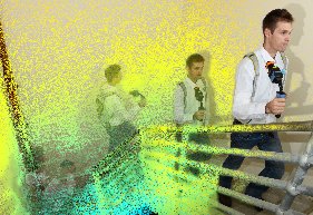
The Zebedee system includes a lightweight laser scanner mounted on a simple spring mechanism. As the operator moves through an environment the scanner loosely oscillates about the spring producing a rotation that converts 2D measurements into 3D fields of view. 3D Laser Mapping said, “Its ability to self-localise makes Zebedee ideally suited for use indoors, underground and other covered environments, such as dense forest and urban canyons, where traditional solutions that utilise GPS don’t function well.”
“Processing the data is just as easy,” Hunter said in the same statement. “There is no need for expensive software or high-end computers; neither do you or your client need lengthy training. The laser scanned measurements are automatically processed on remote servers monitored by highly trained and experienced support staff.”


