

Over the past several years, there has been a concerted effort by the USGS, through the 3D Elevation Program (3DEP) program to provide the first-ever national baseline of consistent high-resolution topographic elevation data covering the US. This is being accomplished through the use of advanced data collection methods, including detailed lidar scans and in Alaska with IfSAR. However, the increase in accuracy and resolution of digital elevation models have highlighted a related issue - our hydrography is out of date and in some cases no longer aligns with the mapped elevation.
Hydrography at a national scale
Since the late 1990s, the USGS and its partners have developed and maintained the National Hydrography Datasets as the authoritative mapping of the nation’s surface water network and watersheds. The current National Hydrography Datasets correspond to the 1:24,000 quad sheets in level of detail and consist of the National Hydrography Dataset (NHD), the Watershed Boundary Dataset (WBD), and the NHDPlus High-Resolution (NHDPlus HR).
These datasets outline surface water features such as rivers, streams, lakes and coastlines. They also provide detailed information about the connectivity of water through the river network. The NHD is used by many government agencies, researchers and other stakeholders involved in water resource management, floodplain mapping, habitat conservation and urban development.
So if hydrographers and water management professionals have been using NHD data for decades for their needs, what’s the challenge? Andrew Brenner, Ph.D, Vice President for Solution Engineering for NV5 Geospatial, says it is a question he hears all the time. He says it comes down to two factors: the need to provide more detail, and provide better accuracy to inform hydrologic and hydraulic models and improve protection of water resources.
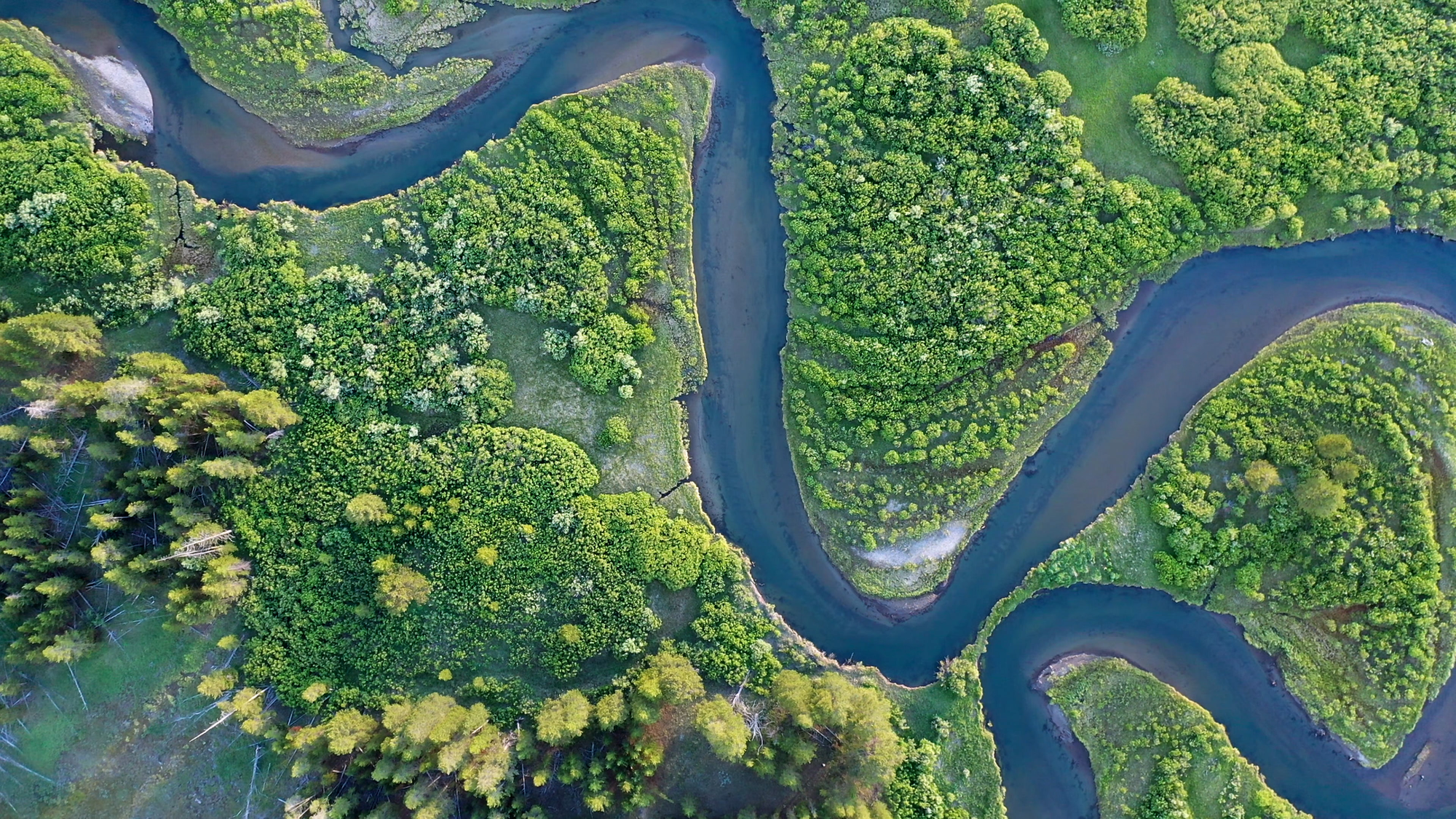
In some cases, legacy data within the NHD (that could have been created in the 1950s-60s and then digitized in the early 2000s) may show rivers in incorrect locations, miss small water bodies, or fail to align with current conditions. Over the last half century land use has changed, and the course of rivers have shifted. To deal with these changes, some agencies have updated the datasets manually for their project areas to better match reality. However, when you zoom out to watershed scales this approach can introduce “inconsistencies” says Brenner.
The 3D Hydrography Program, on the other hand, will be built on high-quality, standardized 3DEP data to ensure spatial and temporal consistency across all derived products. This integration will increase the usability of hydrography datasets for applications like flood modeling and prediction, culvert and bridge engineering design, and stormwater management.
“What hydrologic modelers and mappers have had to do before 3DHP is adjust elevation data locally so water would flow into the channels that correspond to the NHD. Where we would take the NHD and then ‘burn it’ into the elevation to make sure the water ran where it was meant to run, but this means that you’re altering the underlying data,” says Brenner.
NV5 Geospatial has been working with USGS for many years to understand the goals of the elevation-derived program and is working to implement them for client states. They have worked with clients within Pennsylvania, Michigan, Missouri, California, Washington State, Washington DC, Texas and Alaska on elevation-derived hydrography to support the USGS 3DHP.
The next generation of hydrography
The USGS has announced that they are working towards the implementation of the 3D Hydrography Program to completely refresh the Nation’s hydrography data and improve discovery and sharing of water-related data.
The USGS is developing 3DHP as the surface water mapping program of the new 3D National Topography Model (3DNTM). 3DNTM is a new initiative to update and integrate USGS elevation and hydrography data, and the relationships between them, into a 3D model that delivers higher quality data and supports more sophisticated geospatial analysis than was possible with separate datasets. The 3DNTM, including data from the 3DHP and the next generation of the 3D Elevation Program, is designed to provide foundational data to meet the most demanding scientific requirements and enable data-driven decisions across user communities.
Essentially, this represents an effort by the USGS to bring elevation and hydrology together. In the same way that USGS has led the effort to build a national baseline of consistent high-resolution topographic elevation data covering the US, this is their push on the hydrography side.
This process, however, is not simple, says Brenner.
“What we’re finding is that mapping hydrography is very complex and although the principles are simple the variation in slope, soils, geology and land cover, create many situations where a detailed review of the data by analysts is necessary.”
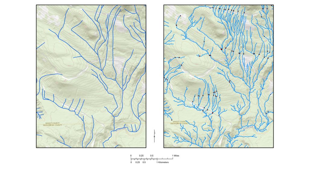
“We’re really trying to represent rivers, streams, ponds and culverts that we haven’t had the data resolution to characterize before, we’re seeing details that we didn’t have to deal with before.”
“One key element of this dataset is standardization. If I use this dataset, I would like to know if a feature is labeled culvert, what’s the definition of a culvert? If a feature is labeled as a stream, what does that mean, likewise with other features like sinkholes. It is important that any person using this dataset across the US understands that if a feature is labeled with an attribute, that the attribute is transferable across watersheds and states. Without this guarantee the USGS provides in terms of its quality control, the dataset becomes much less usable for the general public.”
In addition to the added complexity, the demands on the data itself are increasing. While maps of streams and watersheds might have formerly been used primarily for identification of where there are streams and rivers, there are now myriad applications of the data and questions that the historic dataset wasn’t ready to answer - including how watersheds and water resources might be changing over time, at a national scale. How will climate change impact the flow of rivers and their impact on aquatic habitat?
“What we’re trying to do now is draw deeper scientific conclusions from the data. The demand on the dataset is higher, we need a consistent and accurate dataset so we can apply models over a wide range of circumstances. Models are only useful if the underlying data are good,” says Brenner.
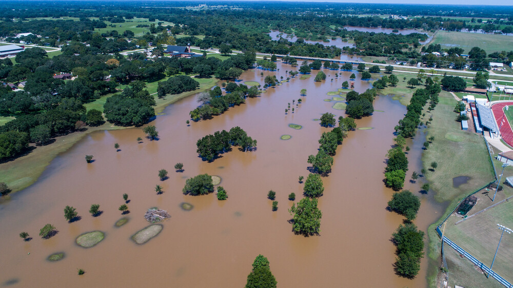
Because the 3DHP will provide critical data related to flood forecasting, agricultural planning, infrastructure design, fisheries, stream ecology, water quality, and other emerging applications, such as blue carbon - getting underlying data correct is important.
“Parts of the world are getting wetter, and parts are getting drier, both trends are going to have impacts. If we have more intense rainfalls, we need to know which areas will be flooded."
“We have culverts that were built 50-60 years ago that might not be designed for the reality of the landscape that drains into them today. That landscape may have more impervious surfaces creating increased runoff. That runoff will create increased sediment transfer that could deposit in the culverts and reduce their drainage effectiveness. Can the culverts that exist within a watershed cope with the current conditions? This level of detailed information that is being developed will start to answer questions like which areas are going to flood regularly over the next 10 years as the watershed and climate changes and what management actions can we take to mitigate this problem.”
Getting everyone at the table
The 3DNTM program, comprising of both the 3DEP and 3DHP are being planned and led by the federal government, with USGS leading the terrestrial portion of the program, and NOAA leading the efforts as they pertain to coastal and offshore information. This work is in close partnership with state, local, and tribal governments across the nation.
What can the geospatial and hydrographic community do to support the 3DHP effort? To put it simply: get involved. Defining the plan and participating as stakeholders helps bring everyone to the table early in the process. Having stakeholders there as the data frameworks are being created can help to avoid situations down the line that will leave out use cases or applications that you care about. For any mapping program, it is much easier, says Brenner, to participate at the beginning and get your specific needs met than to ask for them after the program has been completed, 3DHP is no different.
The USGS National Geospatial Program (NGP) is also changing its process for finding and selecting partnerships beginning in Fiscal Year 2024. The revised and streamlined structure is called the 3DNTM Data Collaboration Announcement (DCA), which is planned to be released in September 2023 (subject to change). The DCA replaces the Broad Agency Announcement (BAA) and is intended to include data acquisition partnerships for both the 3D Elevation Program and the 3D Hydrography Program.
What you can do:
- Read the USGS Call to Action
- Join the NSGIC 3DHP Group - aimed to support the program and educate users of the dataset on how to fund, produce and use the 3DHP Datasets
- Learn about Data Collaboration opportunities and grants
To hear more about getting your own EDH program started, contact the NV5 Geospatial experts at [email protected]


