Every week here at Geo Week News, we have been highlighting some of our favorite stories from around the internet that cover the geospatial, 3D, and AEC industries. Whether it’s a fascinating case study, insights from an industry thought leader, or deep dives into new tools, there is never any shortage of great writing and storytelling in this industry. So, below you can find links to three stories that we loved this week.
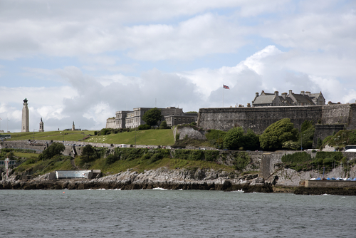
'Forgotten' castle brought to life with AR
Emma Ruminski | BBC
Geospatial historian Chris Harvey has recreated Plymouth, England’s, historic defences that have long since been destroyed along with many records on the matter. Using old maps, documents, and knowledge of architecture at the time, Harvey was able to create a concise map of what the castle looked like in its prime. This project aims at providing historical context and a sense of pride and purpose for the people of Plymouth.
The Cloud, The Edge, and the Beast
Gavin Schrock | XYHT
Long gone are the days when using a single processing platform was the status quo. Experts are recommending all three workstations for optimal performance. Powerful local machines give control and offline capability, but struggle with growing data demands. Cloud platforms like Hexagon’s HxDR offer scalability, AI-powered automation, and easy collaboration across teams, though they depend on connectivity and subscription models. Meanwhile, edge computing, processing data directly on capture devices like drones, vehicles, or sensors, delivers fast, usable insights in the field, reducing backlogs and enabling near-real-time decisions. The future of RC lies in this hybrid model where edge, cloud, and local resources work together to balance speed, precision, scalability, and practicality.
UK rail network to be monitored from space
Staff Writer | GIM International
A UK rail network will be monitored from space using satellite radar technology, providing real time updates and reducing reliance on repeat on-site examinations that are costly, subjective, and untimely. “This is the first time globally that integration of satellite-based ground monitoring has been undertaken at this scale by a major rail operator.”
SatSense is an interferometric synthetic aperture radar (InSAR) technology specialist who will be leading this project in partnership with Network Rail. InSAR technology will be integrated into Network Rail’s internal GIS software to monitor ground movement trends along the rail corridor. This is a significant step for the future of real time rail monitoring.